
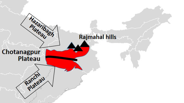
The Hazaribagh Plateau is one of the major physiographic divisions of the Chotanagpur Plateau and forms an important upland region of North Chotanagpur in Jharkhand. It lies north of the Damodar Valley and is separated from the Ranchi Plateau by the lower structural terrain of the Damodar basin. The plateau consists of ancient crystalline rocks, rolling uplands, residual hills, valleys, forested tracts and numerous streams that descend towards the Damodar-Barakar drainage system.
The plateau is geographically important because it forms a transition between the higher central plateau of Jharkhand and the lower northern margins approaching the Gangetic Plain. Its relief has influenced drainage, forest distribution, agriculture, transport and settlement, while its proximity to the Gondwana coal basins has connected Hazaribagh closely with the mining-industrial geography of Ramgarh, Karanpura, Bokaro and the Damodar Valley.
Hazaribagh Plateau at a Glance
| Feature | Important Information |
|---|---|
| Physiographic region | North Chotanagpur |
| Larger plateau system | Chotanagpur Plateau |
| General location | North of the Damodar Valley |
| Average elevation | Broadly around 600 m, with considerable local variation |
| Highest local uplands | Several hills rise well above the general plateau surface |
| Dominant geology | Ancient granite-gneiss and related crystalline rocks |
| Major drainage | Damodar-Barakar system and tributaries |
| Major nearby coal region | Karanpura-Ramgarh-Damodar belt |
| Dominant soils | Red and yellow soils; lateritic soils locally |
| Natural vegetation | Tropical deciduous forest |
| Characteristic tree | Sal |
| Major agricultural crop | Paddy |
| Important urban centre | Hazaribagh |
| Major physical character | Dissected uplland of hills, valleys and forested ridges |
Location of the Hazaribagh Plateau
The Hazaribagh Plateau occupies a central position within North Chotanagpur. Its core lies around Hazaribagh and adjoining areas, while its physical influence extends towards parts of Ramgarh, Koderma, Chatra and Giridih through a complex landscape of uplands, valleys and transitional plateau surfaces.
The plateau is bounded broadly by lower terrain in several directions. To the south lies the Damodar Valley, while towards the north the land gradually descends towards lower plateau margins and eventually the Gangetic Plain. To the east, the terrain merges with the uplands of Giridih and the Parasnath region, while the western side grades towards the Karanpura and Chatra uplands.
This position gives the Hazaribagh Plateau considerable importance as a drainage divide and transitional physiographic zone.
Get all JPSC Notes https://learnpro.in/jpsc-notes/

Hazaribagh Plateau within the Chotanagpur Plateau System
Jharkhand’s plateau relief is arranged at several different levels. The Hazaribagh Plateau belongs broadly to the intermediate plateau surfaces and is comparable in general elevation to the Ranchi Plateau, although its relief is more broken in many areas.
A simplified vertical arrangement is:
Western High Pats – around 900–1,100 m in important areas
↓
Ranchi and Hazaribagh Plateau surfaces – broadly around 600 m
↓
Damodar structural basin and lower valleys
↓
Northern and eastern peripheral lowlands
The Hazaribagh Plateau is therefore neither the highest plateau of Jharkhand nor a low plain. It occupies an intermediate position within the state’s stepped plateau morphology.
Geological Structure of the Hazaribagh Plateau
The Hazaribagh Plateau is built primarily upon the ancient crystalline basement of the Chotanagpur region. Granite, gneiss and related metamorphic rocks form much of its foundation. These rocks belong to some of the oldest geological formations of the Indian Peninsular Shield.
Long periods of weathering and erosion reduced the old land surface, while later tectonic movement and river incision produced the modern landscape. As a result, the plateau contains broad uplands interrupted by residual hills, narrow valleys and local depressions.
The geological evolution can be represented as:
Ancient crystalline basement
↓
Prolonged weathering and erosion
↓
Development of plateau surface
↓
Uplift and river dissection
↓
Modern rolling and dissected relief
Unlike the Damodar Valley immediately to the south, the core plateau itself is not dominated by Gondwana sedimentary rocks.
Relief of the Hazaribagh Plateau
The relief of the Hazaribagh Plateau is undulating and dissected. Its general surface lies broadly around 600 metres above sea level, although local hills and ridges rise significantly higher and valleys descend below the general plateau level.
The principal relief features are:
- broad uplands;
- rolling plateau surfaces;
- isolated hills;
- forested ridges;
- narrow valleys;
- river-cut depressions.
This broken topography gives Hazaribagh a noticeably different appearance from a flat plain. Even where agricultural land is extensive, fields are frequently separated by low ridges, streams and forest patches.
Residual Hills
Residual hills are an important feature of the plateau. They represent resistant rock masses that survived while surrounding material was progressively lowered by erosion.
These hills influence:
- local drainage;
- forest distribution;
- settlement location;
- road alignment;
- scenic landscape.
Several forested ridges around Hazaribagh stand clearly above the surrounding plateau surface and create substantial local differences in elevation.
Hazaribagh Plateau and the Damodar Valley
The southern side of the Hazaribagh Plateau descends towards the Damodar Valley, one of Jharkhand’s most important structural basins. This transition is particularly important because it marks a change from ancient crystalline plateau rocks to younger Gondwana sedimentary formations.
The Damodar basin contains extensive coal deposits, while the higher Hazaribagh Plateau is characterised primarily by crystalline rocks and erosional landforms.
The geological contrast can be summarised as:
| Hazaribagh Plateau | Damodar Valley |
|---|---|
| Ancient crystalline rocks | Gondwana sedimentary rocks |
| Elevated plateau | Lower structural basin |
| Rolling uplands and hills | Broad valleys and coal-bearing troughs |
| Agriculture and forests | Coal mining and industry |
| Numerous small streams | Major Damodar drainage corridor |
This contrast has had major consequences for settlement and economic development.
North Karanpura Basin
The North Karanpura coalfield lies west and south-west of the main Hazaribagh uplands and forms one of the important Gondwana basins associated with the broader region. The basin contains extensive coal-bearing formations and has become a major mining and energy-producing area.
Its existence illustrates how structural depressions occur between or within older plateau surfaces. The coal-bearing basin is geologically younger than the surrounding crystalline uplands.
The development pattern is:
Plateau margin
↓
Gondwana structural basin
↓
Coal deposits
↓
Mining and thermal power
↓
Transport and settlement growth
South Karanpura and Ramgarh Connection
The South Karanpura coalfield and the Ramgarh region lie closer to the southern margins of the Hazaribagh Plateau. Together they form part of the broader Damodar coal-industrial landscape.
Coal extraction and associated industries have greatly altered the original physical environment through:
- open-cast mines;
- spoil dumps;
- railway lines;
- roads;
- industrial settlements;
- reservoirs and water infrastructure.
Thus, the Hazaribagh Plateau is physically an upland region but economically closely linked with the coal basins lying along its margins.
Drainage of the Hazaribagh Plateau
The plateau is drained by numerous streams flowing towards larger river systems, especially the Damodar and Barakar. Because the plateau surface is elevated, streams often begin in shallow valleys and descend towards lower structural basins.
The drainage pattern is controlled by:
- slope;
- geological structure;
- joints and fractures;
- residual hills;
- differences in rock resistance.
The southern part drains extensively towards the Damodar system, while eastern and north-eastern areas contribute to the Barakar and adjoining river networks.
For the broader river network of the state, see Drainage System of Jharkhand.
Damodar River and the Plateau
The Damodar River flows south of much of the main Hazaribagh Plateau and forms an important lower drainage corridor. Numerous smaller streams descend from the plateau towards it.
This has created a characteristic physical relationship:
Hazaribagh upland
↓
Short tributary valleys
↓
Damodar basin
The river therefore functions as both a drainage boundary and a major economic corridor.
Barakar River System
The Barakar River, a major tributary of the Damodar, drains parts of the northern and eastern plateau region. Its tributaries collect water from hills and uplands before descending towards lower valleys.
The Barakar system is especially important because it links the physical geography of Hazaribagh and adjoining northern districts with the wider Damodar Valley.
Streams flowing across hard crystalline rocks can develop:
- rocky channels;
- rapids;
- narrow valleys;
- seasonal fluctuations in discharge.
Watershed Character
Because the plateau surface is elevated, relatively small changes in slope can direct streams towards different basins. Local uplands therefore function as small drainage divides.
A watershed ridge may separate:
stream flowing towards Damodar
from
stream flowing towards Barakar or another tributary system
This makes the plateau an important headwater region even though it is not associated with one single dominant river.
Climate of the Hazaribagh Plateau
The Hazaribagh Plateau has a tropical monsoon climate modified by elevation. Its elevated position results in somewhat milder summer conditions than many lower valleys, although temperatures can still become high during April and May.
The annual climatic cycle broadly consists of:
| Season | Months | General Condition |
|---|---|---|
| Summer | March–May | Hot and relatively dry |
| South-West Monsoon | June–September | Warm, humid and rainy |
| Post-Monsoon | October–November | Falling rainfall and pleasant weather |
| Winter | December–February | Cool and dry |
Winter nights can be considerably cooler than those in lower eastern regions because of altitude and continentality.
Rainfall
Most rainfall is received from the south-west monsoon between June and September. The broader Hazaribagh region generally receives more than 1,000 mm of annual rainfall, but the amount and timing vary considerably between years.
The agricultural importance of rainfall depends not only on the total amount but also on its distribution. Paddy can suffer when prolonged dry spells occur during critical growth stages even if total seasonal rainfall is near normal.
The important relationship is:
Monsoon rainfall
undulating plateau relief
↓
rapid surface runoff
↓
limited dry-season water availability
This explains why water harvesting remains important even in areas receiving substantial annual rainfall.
Temperature and Elevation
The plateau’s elevation produces lower average temperatures than many adjoining lowlands. During summer, temperatures rise sharply during the day, but nights can remain relatively less oppressive than in lower valleys.
During winter, minimum temperatures fall considerably. Cold waves affecting eastern and northern India can produce noticeably cool conditions over the plateau.
The principle is:
Higher elevation → generally lower temperature
This is why Hazaribagh has historically been known for a comparatively moderate climate within Jharkhand.
Soils of the Hazaribagh Plateau
The soils are derived largely from weathering of crystalline rocks and are dominated by red and yellow soils. Lateritic tendencies occur in more intensely weathered uplands, while deeper soils accumulate in valleys and depressions.
Typical characteristics include:
- acidic reaction in many places;
- relatively low natural fertility;
- low organic matter in exposed uplands;
- susceptibility to erosion;
- strong variation in depth.
Relief exerts an important influence on soil quality.
Upland Soils
Higher plateau surfaces and slopes generally contain shallower soils because erosion removes weathered material.
These soils tend to have:
- low water-retention capacity;
- greater drought vulnerability;
- higher erosion risk.
They are better suited to crops capable of tolerating relatively dry conditions than to water-intensive paddy.
Valley Soils
Valley bottoms receive fine sediments and organic material eroded from surrounding slopes. Their soils are therefore generally deeper and retain moisture for longer periods.
These areas support:
- paddy;
- vegetables;
- more intensive seasonal cultivation.
This topographic contrast creates major agricultural variation within short distances.
Agricultural Geography
Agriculture on the Hazaribagh Plateau is strongly monsoon-dependent. Rice is the principal crop in low-lying and moisture-retaining areas, while uplands support maize, pulses, oilseeds and other crops.
The traditional relationship between relief and farming can be represented as:
| Land Position | Moisture Condition | Typical Use |
|---|---|---|
| High upland | Low | Pulses, maize, oilseeds |
| Middle slope | Moderate | Mixed cropping |
| Lowland | High | Paddy |
This arrangement is common across the Chotanagpur Plateau but is especially important in dissected regions such as Hazaribagh.
Rainfed Agriculture and Water Stress
Agriculture remains vulnerable because much of the rainfall arrives within a short monsoon period. Once the monsoon ends, smaller streams shrink and upland soils lose moisture rapidly.
Water scarcity may therefore develop because of:
- rapid runoff;
- limited storage;
- shallow soils;
- seasonal streams;
- uneven groundwater availability.
Small reservoirs, tanks, ponds and watershed structures are particularly valuable in such terrain.
Groundwater
The underlying crystalline rocks do not store groundwater in the same way as thick alluvial deposits. Water occurs mainly in:
- weathered rock layers;
- fractures;
- joints;
- structurally weak zones.
Groundwater availability therefore varies greatly from place to place.
A well located along a fractured rock zone may yield substantial water, while another nearby well drilled into massive unfractured rock may produce much less.
This hard-rock hydrogeology is characteristic of much of Jharkhand.
Natural Vegetation
The natural vegetation of the Hazaribagh Plateau is predominantly tropical deciduous forest, with Sal as the characteristic tree in many areas.
Other important species include:
- mahua;
- kendu;
- palash;
- bamboo;
- kusum.
Forest cover is generally more extensive on hills, rocky uplands and steeper slopes where cultivation is difficult.
Forest Geography
Historically, large sections of the plateau were heavily forested. Agricultural expansion, settlements, roads and mining reduced and fragmented many forest areas, although substantial patches remain.
The relationship between relief and forest survival is clear:
Steep rocky hill → limited cultivation → greater forest persistence
Gentle plateau surface → agricultural expansion → reduced forest cover
Forests also protect the upper catchments of many small rivers and streams.
Hazaribagh Wildlife Landscape
The forested uplands support a variety of wildlife including:
- deer;
- wild boar;
- sloth bear;
- jackal;
- various smaller mammals;
- numerous birds and reptiles.
Forest fragmentation has altered wildlife movement patterns, particularly around expanding roads, settlements and mining areas.
The Hazaribagh landscape therefore represents an important interface between forest ecology and human land use.
Hazaribagh Wildlife Sanctuary
The Hazaribagh Wildlife Sanctuary protects part of the forested hill landscape near Hazaribagh. It preserves deciduous woodland, valleys and upland habitats characteristic of the North Chotanagpur region.
Its geographical significance extends beyond wildlife conservation. Protected forest helps maintain:
- catchment quality;
- soil stability;
- local biodiversity;
- ecological connectivity.
The sanctuary also demonstrates how remnants of the original plateau vegetation survive within an increasingly modified landscape.
Minerals and the Plateau Region
The core Hazaribagh Plateau is not as strongly mineralised as Singhbhum, but the surrounding North Chotanagpur region contains extensive mineral resources.
The most important is coal, concentrated in Gondwana basins such as:
- North Karanpura;
- South Karanpura;
- Ramgarh;
- adjoining Damodar coalfields.
Other rocks and mineral materials are also quarried locally.
The economic importance of the plateau is therefore closely linked to the mineral-rich structural depressions surrounding it.
Coalfields and Physiography
Coalfields occur in lower structural basins rather than uniformly across the higher plateau.
This relationship is important:
Hazaribagh crystalline upland
↓
Faulted structural basin
↓
Gondwana sedimentary deposits
↓
Coal seams
The physical landscape thus reveals the geological processes responsible for mineral distribution.
North Karanpura Coalfield
The North Karanpura Coalfield is one of the most important coal regions associated with the Hazaribagh-Chatra-Ramgarh area. It occupies a broad Gondwana basin surrounded by older rocks.
Coal extraction has produced major changes in:
- land use;
- settlement;
- transport;
- river systems;
- local employment.
Thermal power development has further strengthened the economic importance of the basin.
South Karanpura Coalfield
The South Karanpura Coalfield lies closer to the Damodar Valley and Ramgarh region. Its coal deposits have long supported mining and industrial activity.
The field forms part of a broader coal corridor connecting:
Hazaribagh-Ramgarh
↓
Bokaro
↓
Dhanbad
This mineral-industrial belt represents one of Jharkhand’s most densely developed economic regions.
Hazaribagh and Mica Region
The broader North Chotanagpur region also lies near the historic Koderma-Giridih mica belt. Mica occurs mainly in pegmatite formations associated with ancient crystalline rocks.
Koderma became particularly famous historically for mica mining and trade.
The mineral geography therefore differs sharply over short distances:
- coal in Gondwana basins;
- mica in crystalline pegmatites.
This reinforces the importance of geology in understanding Jharkhand’s resource distribution.
Settlement Pattern
Traditional settlement is concentrated on relatively level plateau surfaces and near agricultural valleys.
Villages generally avoid:
- steep hill slopes;
- rocky ridges;
- poorly watered uplands.
They favour locations with:
- cultivable land;
- water sources;
- road access;
- nearby forests.
Modern mining settlements, however, often developed directly around mineral deposits, producing a different settlement pattern from traditional agricultural villages.
Hazaribagh City
Hazaribagh city is the principal urban centre of the plateau. Its development reflects a combination of administrative, educational, commercial and transport functions.
The city occupies relatively favourable plateau terrain and serves as a service centre for the surrounding rural region.
Its geographical advantages include:
- moderate elevation;
- central location in North Chotanagpur;
- access to regional highways;
- proximity to coal and mineral areas.
Unlike Dhanbad, however, Hazaribagh itself did not develop solely as a mining city.
Urban Growth
Expansion of Hazaribagh has led to increasing conversion of agricultural and open land around the city.
Major pressures include:
- road expansion;
- residential colonies;
- commercial development;
- groundwater extraction;
- reduction of local wetlands and ponds.
Urban growth therefore increasingly influences the natural drainage system of the plateau.
Transport Geography
The plateau’s rolling and broken relief historically made road construction more difficult than on plains. Routes had to follow gentler slopes, valleys and passes.
Modern highways have greatly improved connectivity, linking Hazaribagh with:
- Ranchi;
- Ramgarh;
- Koderma;
- Barhi;
- Chatra;
- Bokaro.
The region’s transport importance increased further because major national routes connecting northern and eastern India cross or approach the plateau.
Barhi and the Northern Corridor
The Barhi region north of Hazaribagh is an important transport junction connecting routes towards Bihar, Koderma, Dhanbad and central Jharkhand.
Its development reflects the importance of relatively favourable passages across the plateau.
Transport corridors have encouraged:
- market development;
- service industries;
- roadside settlement;
- regional migration.
Thus, physiography continues to influence modern economic geography.
Hazaribagh Plateau and Ranchi Plateau: Comparison
| Feature | Hazaribagh Plateau | Ranchi Plateau |
|---|---|---|
| Location | North of Damodar Valley | South of Damodar Valley |
| General elevation | Broadly around 600 m | Roughly 600–700 m |
| Relief | Strongly dissected upland | Broad undulating plateau |
| Major drainage | Damodar-Barakar tributaries | Subarnarekha-South Koel systems |
| Major nearby mineral | Coal | Bauxite towards western margin |
| Famous landform | Hills and forested ridges | Major waterfalls |
| Major city | Hazaribagh | Ranchi |
| Economic connection | Coal belt and regional services | Administration and services |
The Damodar Valley is the major physiographic feature separating the two plateau regions.
Hazaribagh Plateau and Western Pats
The Hazaribagh Plateau is considerably lower than many of the western Pat surfaces.
| Feature | Hazaribagh Plateau | Western Pats |
|---|---|---|
| General level | Intermediate plateau | High plateau |
| Typical elevation | Around 600 m in broad areas | Often 900–1,100 m |
| Relief | Rolling and dissected | Flat-topped uplands with steep margins |
| Major mineral association | Coal basins nearby | Bauxite |
| Vegetation | Deciduous forest | Extensive forest in many areas |
This comparison illustrates Jharkhand’s stepped plateau structure.
Relationship with Parasnath
East of Hazaribagh lies the higher Parasnath-Shikharji region of Giridih. Parasnath rises to approximately 1,365 metres, far above the general Hazaribagh plateau surface.
This difference demonstrates the presence of isolated residual highlands within the wider northern Chotanagpur landscape.
The surrounding Giridih uplands form an important transition between:
- Hazaribagh Plateau;
- Barakar basin;
- eastern Chotanagpur uplands.
Environmental Problems
The Hazaribagh Plateau and surrounding North Chotanagpur region face several environmental pressures.
Important problems include:
- deforestation;
- soil erosion;
- mining-related land degradation;
- coal dust;
- water pollution;
- groundwater stress;
- loss of agricultural land;
- habitat fragmentation.
These pressures are most intense near coal-mining and rapidly urbanising areas.
Mining and Land Degradation
Open-cast coal mining in nearby basins can transform large areas of land. Soil and rock overburden must be removed before coal seams can be accessed.
The effects may include:
- removal of vegetation;
- destruction of topsoil;
- spoil heaps;
- alteration of drainage;
- dust generation;
- groundwater disturbance.
Reclamation therefore becomes essential after mining.
Soil Erosion
The combination of heavy monsoon rainfall and undulating terrain makes exposed soils vulnerable to erosion.
Erosion is most severe where:
- forest vegetation has been removed;
- slopes are cultivated without protection;
- mine spoil remains exposed;
- surface drainage is uncontrolled.
The eroded soil can accumulate in tanks and reservoirs, reducing their storage capacity.
Watershed Management
Because the plateau experiences rapid monsoon runoff, watershed management has particular importance.
Useful measures include:
- contour bunding;
- check dams;
- farm ponds;
- vegetation restoration;
- gully plugging;
- recharge structures.
The objective is to slow water movement from uplands and increase infiltration into soil and fractured rock.
Agriculture, Forest and Mining: Competing Land Uses
The Hazaribagh region contains three major competing uses of land:
Agriculture
Forests
Mining and infrastructure
Expansion of one can reduce the land available for the others.
Coal-bearing basins are especially sensitive because mineral resources may occur beneath farmland or forest. This creates conflicts involving livelihoods, environmental conservation and industrial development.
Economic Geography
The Hazaribagh Plateau does not have the same heavy-industrial concentration as Dhanbad or Jamshedpur, but it lies close to some of Jharkhand’s most important resource regions.
Its economy is supported by:
- agriculture;
- forest resources;
- services;
- transport;
- nearby coal mining;
- trade and education.
The plateau functions as an important link between the agricultural interior of North Chotanagpur and the mineral-industrial Damodar belt.
Geographical Importance of the Hazaribagh Plateau
The importance of the plateau can be understood through several relationships.
Relief and Drainage
Elevated uplands → tributary streams → Damodar-Barakar basin
Geology and Minerals
Crystalline plateau → surrounding Gondwana basins → coalfields
Relief and Agriculture
Uplands → dry farming
Valleys → paddy cultivation
Relief and Forests
Rugged hills → greater forest survival
Physiography and Transport
Valleys and passes → road corridors
These relationships make the Hazaribagh Plateau an important example of how physical geography shapes human activity.
Core Data on the Hazaribagh Plateau
| Indicator | Key Information |
|---|---|
| Location | North Chotanagpur |
| General elevation | Broadly around 600 m |
| Dominant rocks | Ancient granite-gneiss crystalline complex |
| Major southern boundary | Damodar Valley |
| Major drainage | Damodar-Barakar tributaries |
| Important nearby coalfields | North Karanpura, South Karanpura, Ramgarh |
| Main soils | Red and yellow soils |
| Natural forest type | Tropical deciduous |
| Characteristic tree | Sal |
| Main crop | Paddy |
| Main city | Hazaribagh |
| Major economic links | Agriculture, services, coal belt |
| Major environmental issues | Deforestation, erosion, mining degradation, water stress |
Hazaribagh Plateau in Jharkhand Geography
The Hazaribagh Plateau occupies a crucial position between the Damodar coal basin and the northern plateau margins of Jharkhand. Its ancient crystalline foundation forms an elevated surface that has been deeply dissected by tributaries of the Damodar and Barakar.
The plateau can therefore be understood as a landscape of:
Ancient rocks
↓
Rolling uplands
↓
River-cut valleys
↓
Agricultural lowlands and forested hills
At its southern and western margins, structural basins filled with Gondwana sediments introduce a completely different economic geography based on coal.
Thus, the Hazaribagh Plateau combines old crystalline landforms, forests, agriculture and nearby mineral basins, making it one of the most geographically varied regions of North Chotanagpur.
Frequently Asked Questions (FAQs)
1. Where is the Hazaribagh Plateau located?
The Hazaribagh Plateau lies in North Chotanagpur in northern-central Jharkhand.
2. Of which larger plateau is it a part?
It forms part of the Chotanagpur Plateau.
3. What is the general elevation of the Hazaribagh Plateau?
Large parts broadly lie around 600 metres above mean sea level, although local elevations vary considerably.
4. Which plateau lies south of the Damodar Valley?
The Ranchi Plateau lies mainly south of the Damodar Valley, while the Hazaribagh Plateau lies to its north.
5. What separates the Ranchi and Hazaribagh plateaus?
The Damodar Valley and associated lower structural terrain form the principal physiographic separation.
6. Which rocks dominate the Hazaribagh Plateau?
The plateau consists mainly of ancient granite-gneiss and related crystalline and metamorphic rocks.
7. What type of relief characterises the plateau?
It has a rolling and deeply dissected upland relief with residual hills, ridges and valleys.
8. Which river system drains much of the plateau?
Much of the plateau drains towards the Damodar-Barakar river system.
9. Which major coalfields lie near the Hazaribagh Plateau?
Important nearby fields include North Karanpura, South Karanpura and Ramgarh.
10. Why does coal occur near the plateau?
Coal occurs in Gondwana sedimentary basins formed in structural depressions adjoining the older crystalline plateau.
11. Is the Hazaribagh Plateau itself a Gondwana coal basin?
No. The plateau core is predominantly ancient crystalline terrain; the major coal deposits occur mainly in adjoining structural basins.
12. Which soils are widespread?
Red and yellow soils dominate much of the plateau.
13. Why are upland soils relatively dry?
Uplands have shallower soils and lose rainfall rapidly through runoff and drainage.
14. Why are valley soils more productive?
They receive eroded sediment and retain more moisture, making them better suited to agriculture.
15. Which crop dominates the lowlands?
Paddy or rice is the major lowland crop.
16. Which crops are suitable for uplands?
Maize, pulses and oilseeds are important crops on relatively dry uplands.
17. What is the dominant natural vegetation?
The natural vegetation is mainly tropical deciduous forest, particularly Sal forest.
18. Why do forests survive mainly on hills and rugged terrain?
Steep and rocky terrain is less suitable for intensive cultivation and settlement, allowing more forest to survive.
19. What type of climate does the plateau have?
It has a tropical monsoon climate modified by elevation.
20. Why is Hazaribagh relatively cooler than many lower valleys?
Its plateau elevation moderates temperature.
21. When does the region receive most rainfall?
Most rainfall occurs during the south-west monsoon from June to September.
22. Why can water scarcity occur despite monsoon rainfall?
Undulating relief creates rapid runoff, while seasonal streams and hard-rock groundwater limit dry-season water availability.
23. How is groundwater stored in the Hazaribagh Plateau?
Groundwater occurs mainly in weathered rock zones, joints and fractures.
24. What is the importance of the North Karanpura Coalfield?
It is one of the major Gondwana coal basins of North Chotanagpur and supports extensive mining and power generation.
25. What is the significance of the Ramgarh region?
Ramgarh lies near the southern plateau margin and forms part of the important Damodar coal-industrial belt.
26. How does Hazaribagh Plateau differ from Ranchi Plateau?
Hazaribagh is generally more strongly associated with the Damodar-Barakar drainage and nearby coal basins, while Ranchi forms the major watershed of the Subarnarekha and South Koel and is especially famous for waterfalls.
27. How does it differ from the western Pats?
The western Pats are considerably higher, commonly reaching around 900–1,100 metres, while the Hazaribagh Plateau forms an intermediate level.
28. What are the main environmental problems of the region?
Major problems include deforestation, soil erosion, mining-related land degradation, water pollution and groundwater stress.
29. Why is watershed management important?
It helps reduce rapid runoff, control erosion and improve groundwater recharge and agricultural water availability.
30. What is the main geographical significance of the Hazaribagh Plateau?
The Hazaribagh Plateau is an ancient crystalline upland forming the northern intermediate level of the Chotanagpur Plateau and linking the agricultural-forest landscape of North Chotanagpur with the coal-bearing Damodar and Karanpura basins.





