
The Barakar River is one of the most important rivers of Jharkhand and the principal tributary of the Damodar River. Rising in the northern part of the Chotanagpur Plateau, it flows generally from west to east through Jharkhand before joining the Damodar near the Jharkhand–West Bengal border region. The river is especially important because of the Tilaiya and Maithon dams, its association with the Damodar Valley Corporation (DVC), and its close relationship with the mineral-rich and heavily industrialised Damodar–Barakar coal belt.
For JPSC, the Barakar should not be studied merely as a river-name question. It connects Jharkhand Geography, river systems, multipurpose projects, coalfields, industrialisation, hydropower and regional development.
Candidates can also revise the broader river network through Drainage System of Jharkhand.

Barakar River: Basic Geography
The Barakar forms an important part of the Damodar drainage system of eastern India. It originates in the uplands of northern Jharkhand and traverses the plateau landscape before entering the lower Damodar region.
Its broad geographical characteristics are:
| Feature | Barakar River |
|---|---|
| River system | Damodar |
| Major basin | Ganga basin through the Damodar–Hooghly system |
| Source region | Northern Chotanagpur Plateau |
| State primarily traversed | Jharkhand |
| Lower-course association | Jharkhand–West Bengal border region |
| General direction | West to east |
| Confluence | Damodar River |
| Approximate length | About 225–260 km, depending on source/mapping method |
| Important dams | Tilaiya, Maithon |
| Important tributaries | Usri, Barsoti |
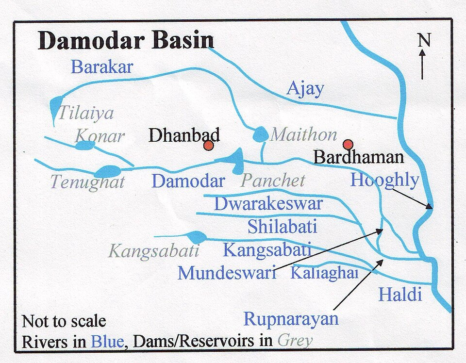
The river is important both physically and economically because it flows across a plateau region rich in coal and other mineral resources.
Source of the Barakar River
The Barakar rises in the Hazaribagh–Koderma plateau region of Jharkhand. The source is generally associated with the Padma area of the northern Chotanagpur Plateau.
This is an elevated plateau landscape composed largely of ancient hard rocks. The upper Barakar therefore initially flows through a terrain characterised by:
- plateau uplands;
- rocky channels;
- seasonal runoff;
- narrow valleys;
- forested slopes in places.
The nature of the upper valley later proved suitable for constructing the Tilaiya Dam.
Course of the Barakar River
The Barakar generally follows a west-to-east course across northern Jharkhand.
Its course can be understood in three broad sections.
Upper Course
The river begins in the plateau region around Hazaribagh–Koderma.
Here the valley is comparatively narrow and uneven because the river flows through the resistant rocks of the Chotanagpur Plateau.
The first major multipurpose project on the river, the Tilaiya Dam, lies in this upper section.
Middle Course
After leaving the upper plateau, the Barakar flows through or close to the Giridih region.
Several smaller streams drain the plateau and join it along this section.
The important Usri River belongs to the Barakar drainage network and helps drain parts of the Giridih plateau.
Lower Course
Farther east, the Barakar approaches the Dhanbad–Nirsa–Chirkunda coal and industrial region.
The river is impounded at Maithon, creating one of the most important reservoirs in eastern India.
Below Maithon, the Barakar continues eastward and ultimately joins the Damodar River near the Dishergarh–Asansol region.
Thus the drainage sequence is:
Barakar → Damodar → lower Bengal drainage → Hooghly system
Districts Associated with the Barakar River
The Barakar and its basin are particularly associated with:
- Hazaribagh
- Koderma
- Giridih
- Dhanbad
Its lower basin also influences the adjoining industrial areas of West Bengal.
For examination purposes, the most important district associations are:
Tilaiya → Koderma
Maithon → Dhanbad
Usri → Giridih region
Lower Barakar → Nirsa–Chirkunda–Asansol industrial belt
Barakar as a Tributary of the Damodar
The Barakar is generally regarded as the most important tributary of the Damodar River.
The Damodar basin contains several important rivers, including:
- Damodar;
- Barakar;
- Konar;
- Bokaro;
- Jamunia and smaller tributaries.
Among these, the Barakar has particular significance because it has a large catchment and carries substantial monsoon runoff into the lower Damodar system.
Before the development of the Damodar Valley multipurpose project, large monsoon flows from rivers such as the Barakar contributed to destructive flooding in the lower Damodar basin.
This explains why flood control became one of the major objectives of the Damodar Valley Corporation.
Tributaries of the Barakar River
The Barakar receives numerous seasonal and perennial streams from the plateau.
Its two commonly identified important tributaries are:
Usri River
The Usri drains parts of the Giridih plateau and joins the Barakar system.
It is also associated with the well-known Usri Falls near Giridih.
The Usri is important for JPSC because it links:
river geography + plateau relief + waterfall formation + Giridih district.
Barsoti River
The Barsoti is another significant tributary of the Barakar.
It drains the plateau region before joining the main river.
Several smaller streams also feed the Barakar, particularly during the monsoon.
Usri River and Usri Falls
The Usri deserves special attention because it is one of the better-known tributaries within the Barakar drainage system.
Near Giridih, the river descends over resistant rocks, creating Usri Falls.
This is typical of Jharkhand’s plateau drainage, where rivers frequently descend across:
- hard rock surfaces;
- structural breaks;
- escarpments;
- uneven plateau levels.
This same physical setting explains why Jharkhand contains numerous waterfalls despite not having very large Himalayan-type rivers.
Barakar River Basin
The Barakar basin forms part of the larger Damodar basin.
Its catchment contains:
- plateau uplands;
- forested tracts;
- agricultural land;
- mineral-bearing formations;
- mining areas;
- reservoirs;
- industrial settlements.
The basin receives most of its rainfall during the southwest monsoon.
Consequently, the river historically displayed considerable seasonal variation:
high monsoon discharge
and
much lower dry-season flow.
Reservoir construction helped regulate this seasonal imbalance.
Why Dams Were Built on the Barakar
Before major dams were constructed, the Damodar–Barakar system was associated with severe monsoon flooding.
Heavy rainfall over the plateau rapidly entered the river network because of:
- steep local slopes;
- intense monsoon rain;
- relatively rapid runoff;
- tributary convergence.
The resulting flood peaks travelled downstream into West Bengal.
After independence, the river basin was selected for a large multipurpose development programme based partly on the concept of integrated river-valley planning.
The Damodar Valley Corporation was established for this purpose.
Damodar Valley Corporation and the Barakar
The Damodar Valley Corporation (DVC) was established in 1948.
It became one of independent India’s earliest major experiments in integrated multipurpose river-valley development.
Its objectives included:
- flood control;
- irrigation;
- electricity generation;
- water management;
- regional development.
The Barakar became central to this programme because two of the major DVC dams were constructed directly on it:
Tilaiya Dam
and
Maithon Dam
Tilaiya Dam on the Barakar River
The Tilaiya Dam was the first major dam constructed under the Damodar Valley Corporation programme.
It was built across the Barakar River in present-day Koderma district.
The dam was commissioned in 1953.
| Feature | Tilaiya Dam |
|---|---|
| River | Barakar |
| District | Koderma |
| Commissioned | 1953 |
| Project | Damodar Valley Corporation |
| Type | Concrete gravity dam |
| Main functions | Flood moderation, hydropower, water regulation |
The dam is about 366 metres long and approximately 30 metres high above the river-bed level.
Importance of Tilaiya Dam
Tilaiya was historically important because it marked the beginning of large-scale multipurpose development of the Damodar basin.
Its functions included:
Flood Control
Storing part of the monsoon runoff helped moderate downstream flood peaks.
Hydroelectric Power
The project contains a small hydroelectric station.
Water Regulation
Stored water could be released more systematically during periods of reduced river flow.
Regional Development
The reservoir contributed to fisheries, local economic activities and transport/tourism development around the area.
Why Tilaiya Was an Important Planning Landmark
Tilaiya was more than simply a dam.
It represented the early post-Independence development philosophy of using river valleys for multiple purposes simultaneously.
Instead of constructing infrastructure only for irrigation or only for electricity, the DVC model attempted to combine:
flood control + power + irrigation + regional development.
This integrated planning concept is important for both Jharkhand Geography and post-Independence economic geography.
Maithon Dam on the Barakar River
The second major dam on the Barakar is the Maithon Dam, located in the Dhanbad region near the Jharkhand–West Bengal boundary.
It was commissioned in 1957.
| Feature | Maithon Dam |
|---|---|
| River | Barakar |
| District | Dhanbad |
| Commissioned | 1957 |
| Agency | DVC |
| Main purposes | Flood control, power generation, water regulation |
| Special feature | Underground hydroelectric power station |
Maithon is one of the most important multipurpose reservoirs in Jharkhand.
Underground Power Station at Maithon
One of Maithon’s most distinctive features is its underground hydroelectric power station.
The station has traditionally been highlighted as one of the earliest major underground hydel installations of its kind in the region.
The hydroelectric generating capacity is around 60 MW.
This makes Maithon a favourite objective-exam topic because a question can combine:
Barakar River
Maithon Dam
DVC
underground hydel station
Maithon Reservoir
The reservoir created behind Maithon Dam forms a large artificial lake.
Its functions include:
- flood storage;
- water regulation;
- hydropower;
- fisheries;
- recreation and tourism.
The reservoir has also become an important recreational destination for people from:
- Dhanbad;
- Asansol;
- Chirkunda;
- surrounding industrial settlements.
Tilaiya vs Maithon Dam
| Feature | Tilaiya | Maithon |
|---|---|---|
| River | Barakar | Barakar |
| District | Koderma | Dhanbad |
| Completed/commissioned | 1953 | 1957 |
| DVC status | First major DVC dam | Major later DVC dam |
| Hydropower | Small hydel station | Major underground hydel station |
| Primary importance | Upper basin regulation | Lower Barakar flood regulation and power |
The simplest mnemonic is:
Barakar has TWO major DVC dams — Tilaiya upstream, Maithon downstream.
Barakar and the Damodar–Barakar Coal Belt
The economic geography of the Barakar cannot be understood without the coal belt.
The broader Damodar valley contains some of India’s most important coalfields.
The Barakar lower basin lies close to major mining and industrial areas including:
- Dhanbad;
- Nirsa;
- Chirkunda;
- Jharia region;
- Raniganj–Asansol belt farther east.
Coal-bearing formations in the Damodar valley played a decisive role in the growth of eastern India’s industrial economy.
Why Coal Occurs in the Damodar–Barakar Region
The Damodar basin contains extensive Gondwana sedimentary formations.
These rocks formed in ancient continental basins where plant material accumulated in swampy environments and was subsequently buried and transformed into coal.
Important Gondwana geological units include formations associated with major coal seams.
The term Barakar Formation itself is important in Indian geology because it is a major coal-bearing unit of the Lower Gondwana sequence.
This makes “Barakar” significant in two different senses:
- Barakar River
- Barakar Formation, an important coal-bearing geological formation.
Barakar Formation and Coal
The Barakar Formation is particularly important in the geology of Jharkhand.
It contains economically important coal seams in several Gondwana coalfields.
The broader Gondwana succession typically includes units such as:
- Talchir;
- Barakar;
- Barren Measures;
- Raniganj.
Among these, the Barakar Formation is especially important for coal occurrence.
This is why the Damodar valley became the core of India’s early coal-mining and heavy-industrial region.
Major Coalfields Near the Barakar–Damodar System
Important coalfields associated with the wider Damodar valley include:
Jharia Coalfield
Located primarily in Dhanbad district, Jharia is one of India’s most important coking-coal fields.
Bokaro Coalfield
Situated farther west in the Damodar basin.
Ramgarh Coalfield
Associated with the upper-middle Damodar region.
North Karanpura Coalfield
Important in north-central Jharkhand.
South Karanpura Coalfield
Another major Damodar valley coalfield.
Raniganj Coalfield
Located mainly in West Bengal and associated with the lower Damodar–Barakar industrial belt.
The Barakar is therefore part of a larger coal-river-industrial system, rather than a single isolated mining area.
Barakar River and Dhanbad Coal Region
The lower Barakar reaches the northeastern part of Dhanbad district, one of India’s best-known coal-producing regions.
Settlements such as Nirsa and Chirkunda grew within this mineral-industrial landscape.
The river contributes to the region through:
- reservoir water;
- industrial water availability;
- power generation;
- settlement development;
- transport corridors.
At the same time, intensive mining and industrialisation create environmental pressures on the broader Damodar–Barakar basin.
Barakar River and Industrialisation
The Damodar–Barakar region became one of India’s major industrial belts because several favourable factors occurred together:
Coal
Large Gondwana coal reserves.
Water
Damodar and Barakar river systems.
Power
Hydroelectric and later thermal power generation.
Railways
Dense rail connectivity developed to move coal and industrial goods.
Markets
The region lies close to the industrial and urban economy of eastern India.
Together these factors encouraged development of:
- coal mining;
- thermal power plants;
- steel and engineering industries;
- cement and mineral-based industries;
- large urban-industrial settlements.
Barakar River and Thermal Power
Although Tilaiya and Maithon are primarily associated with hydroelectricity and reservoir management, the wider Damodar valley became one of India’s most important thermal-power regions.
This is because coal mines and water resources occur in close proximity.
Thermal plants require large quantities of water for:
- cooling;
- steam generation;
- ash management.
Thus the river system indirectly supported the emergence of a major power-producing region.
Barakar and Flood Control
Flood control was historically one of the most important reasons for building reservoirs on the Barakar.
Before DVC dams, intense monsoon runoff from the Damodar’s tributaries could produce severe downstream floods.
Tilaiya and Maithon reservoirs can temporarily store part of this water and release it in a regulated manner.
The principle is:
Heavy monsoon rainfall
↓
Reservoir storage
↓
Reduced immediate downstream peak discharge
↓
Lower flood intensity
This does not mean floods can be eliminated completely. Reservoir operations, basin-wide rainfall and downstream conditions still determine actual flood behaviour.
Barakar and Irrigation
Water stored in the DVC reservoir system contributes to wider irrigation and water-management arrangements in the Damodar valley.
The key point is that individual dams should be understood as components of a basin-wide system.
Water released from upstream reservoirs ultimately supports downstream storage, barrages and canal systems.
Thus Barakar reservoirs contribute indirectly to agricultural development beyond their immediate local surroundings.
Barakar River and Fisheries
Reservoir construction created extensive standing-water bodies at:
- Tilaiya;
- Maithon.
These reservoirs provided opportunities for inland fisheries.
Fish production can:
- support local livelihoods;
- supplement food supply;
- diversify the reservoir economy.
However, reservoir ecosystems differ considerably from natural river ecosystems, so dam construction also changes aquatic habitats.
Environmental Issues in the Barakar Basin
The Barakar basin faces several environmental pressures.
Mining
Coal mining can generate:
- mine drainage;
- suspended solids;
- land degradation;
- overburden dumps.
Industrial Pollution
Industrial settlements may contribute:
- wastewater;
- heavy metals;
- chemical pollutants.
Urban Waste
Growing towns can add untreated sewage and solid waste.
Reservoir Sedimentation
Soil erosion in the catchment gradually deposits sediment in reservoirs.
Deforestation
Loss of vegetation can increase runoff and soil erosion.
These problems show why river-basin development must combine infrastructure with environmental management.
Mining and River Pollution
Coal-mining districts present particular challenges.
Mining can expose sulphur-bearing rocks and other minerals. Water passing through mines and waste material can alter water chemistry.
Other problems include:
- coal dust;
- sediment;
- mine water discharge;
- abandoned mines.
Because the Barakar is part of a heavily industrialised basin, water-quality management is an important long-term issue.
Barakar River and Jharkhand’s Economic Geography
The river illustrates the close relationship between physical geography and economic geography in Jharkhand.
The sequence can be understood as:
Gondwana geology
↓
Coal deposits
↓
Mining
↓
Railway development
↓
Power generation
↓
Industrialisation
while simultaneously:
Plateau drainage
↓
Barakar River
↓
DVC dams
↓
Flood control + water + hydropower
Together these processes helped create the Damodar industrial region.
Barakar River vs Damodar River
| Feature | Barakar | Damodar |
|---|---|---|
| Status | Tributary | Main river |
| Regional importance | Major northern tributary | Principal basin river |
| Major DVC dams | Tilaiya, Maithon | Panchet |
| Coal association | Dhanbad–Nirsa–lower Barakar belt | Wider Damodar coal belt |
| Confluence relationship | Joins Damodar | Receives Barakar |
| General significance | Flood regulation, hydropower, coal belt | Main drainage and industrial axis |
Candidates should particularly remember:
Maithon is on Barakar, not Damodar.
Panchet is on Damodar, not Barakar.
Barakar vs Konar River
Another frequent source of confusion is the Konar River.
Both are tributaries of the Damodar, but:
Tilaiya Dam → Barakar
Konar Dam → Konar
Maithon Dam → Barakar
Panchet Dam → Damodar
This four-way matching is worth memorising exactly.
Important Places Associated with the Barakar
| Place | Association |
|---|---|
| Padma/Hazaribagh region | Source region |
| Koderma | Tilaiya Dam |
| Giridih | Usri tributary region |
| Maithon | Major dam and reservoir |
| Nirsa | Lower Barakar coal-industrial region |
| Chirkunda | Jharkhand–West Bengal border coal belt |
| Dishergarh region | Confluence with Damodar |
Barakar River Map-Based Preparation
For JPSC, candidates should be able to draw a rough eastward river sketch:
Hazaribagh/Koderma
→ Tilaiya
→ Giridih region
→ Dhanbad/Nirsa
→ Maithon
→ Barakar–Dishergarh
→ Damodar
Then mark:
- Usri;
- Barsoti;
- Tilaiya Dam;
- Maithon Dam;
- Dhanbad coal belt.
This single sketch can help solve several map-based questions.
Barakar River: Prelims Facts
Remember these facts:
- Barakar is a tributary of the Damodar.
- It originates in Jharkhand’s Chotanagpur Plateau region.
- It generally flows west to east.
- Tilaiya Dam is built on the Barakar.
- Maithon Dam is also built on the Barakar.
- Tilaiya was the first major DVC dam.
- Maithon has an important underground hydel power station.
- Usri is an important tributary.
- The basin is associated with the Gondwana coal region.
- The lower Barakar lies close to the Dhanbad–Nirsa–Chirkunda industrial belt.
Barakar River for JPSC Mains
For a descriptive answer, the Barakar can be presented under four dimensions.
Physical Geography
- source;
- course;
- tributaries;
- Damodar confluence.
Water Resource Development
- Tilaiya;
- Maithon;
- DVC;
- flood control.
Economic Geography
- coal;
- mining;
- power;
- industrialisation.
Environmental Geography
- mining pollution;
- industrial effluents;
- sedimentation;
- catchment degradation.
This converts a simple river topic into a strong multidimensional answer.
Frequently Asked Questions
1. Where does the Barakar River originate?
The Barakar rises in the northern Chotanagpur Plateau region of Jharkhand, commonly associated with the Hazaribagh–Padma region.
2. Barakar is a tributary of which river?
It is a major tributary of the Damodar River.
3. In which direction does the Barakar flow?
Its general course is from west to east.
4. Which major dams are built on the Barakar River?
The two most important are Tilaiya Dam and Maithon Dam.
5. Tilaiya Dam is built on which river?
Barakar River.
6. Where is Tilaiya Dam located?
It is located in Koderma district, Jharkhand.
7. When was Tilaiya Dam commissioned?
It was commissioned in 1953.
8. Why is Tilaiya Dam important?
It was the first major dam completed under the Damodar Valley Corporation programme.
9. Maithon Dam is built on which river?
Barakar River.
10. Where is Maithon Dam?
It is located in the Dhanbad region of Jharkhand, close to the West Bengal boundary.
11. When was Maithon Dam commissioned?
It was commissioned in 1957.
12. What is special about Maithon?
Maithon is particularly noted for its underground hydroelectric power station.
13. What are the important tributaries of the Barakar?
Usri and Barsoti are among its important tributaries.
14. Usri Falls is associated with which river?
It is associated with the Usri River, within the Barakar drainage system.
15. Which district is Usri Falls associated with?
Giridih district.
16. Where does the Barakar join the Damodar?
It joins the Damodar in the lower Barakar–Dishergarh region near the Jharkhand–West Bengal industrial belt.
17. Is Panchet Dam on the Barakar?
No. Panchet Dam is on the Damodar River.
18. Is Konar Dam on the Barakar?
No. Konar Dam is on the Konar River.
19. Which DVC dams are located on the Barakar?
Tilaiya and Maithon.
20. What is the Barakar Formation?
The Barakar Formation is an important coal-bearing unit of the Gondwana geological system.
21. Why is the Barakar region important for coal?
The wider Damodar–Barakar basin contains extensive Gondwana coal-bearing formations and lies near major coalfields and mining districts.
22. Which major coal district lies near the lower Barakar?
Dhanbad.
23. Which settlements are associated with the lower Barakar coal belt?
Important examples include Nirsa and Chirkunda.
24. What is the economic importance of the Barakar River?
It supports water storage, hydropower, flood moderation, fisheries, industrial water supply and development of the Damodar coal-industrial region.
25. Why was DVC created?
DVC was created for integrated development of the Damodar basin, particularly flood control, power generation, irrigation and regional development.
26. When was DVC established?
The Damodar Valley Corporation was established in 1948.
27. Is the Barakar part of the Chotanagpur Plateau drainage?
Yes. Much of its upper and middle basin drains the Chotanagpur Plateau.
28. What are the major environmental problems in the Barakar basin?
Important issues include mining-related pollution, industrial discharge, soil erosion, reservoir sedimentation and catchment degradation.
29. Why is Barakar important for JPSC?
It connects several syllabus areas: Jharkhand drainage, DVC, dams, coal geology, mining, industry and environmental geography.
30. What is the easiest way to remember Barakar dams?
Remember:
BARA-KAR = Tilaiya + Maithon
while:
Konar → Konar Dam
and
Damodar → Panchet Dam.





