
The Ranchi Plateau is one of the most important physiographic divisions of the Chotanagpur Plateau and forms the geographical core of central Jharkhand. It is a broad, elevated and deeply weathered plateau surface generally lying at about 600–700 metres above mean sea level, though local elevations vary considerably. Ranchi city itself stands at roughly 650 metres, giving the region a noticeably milder climate than the lower Damodar, Palamu and eastern valley regions.
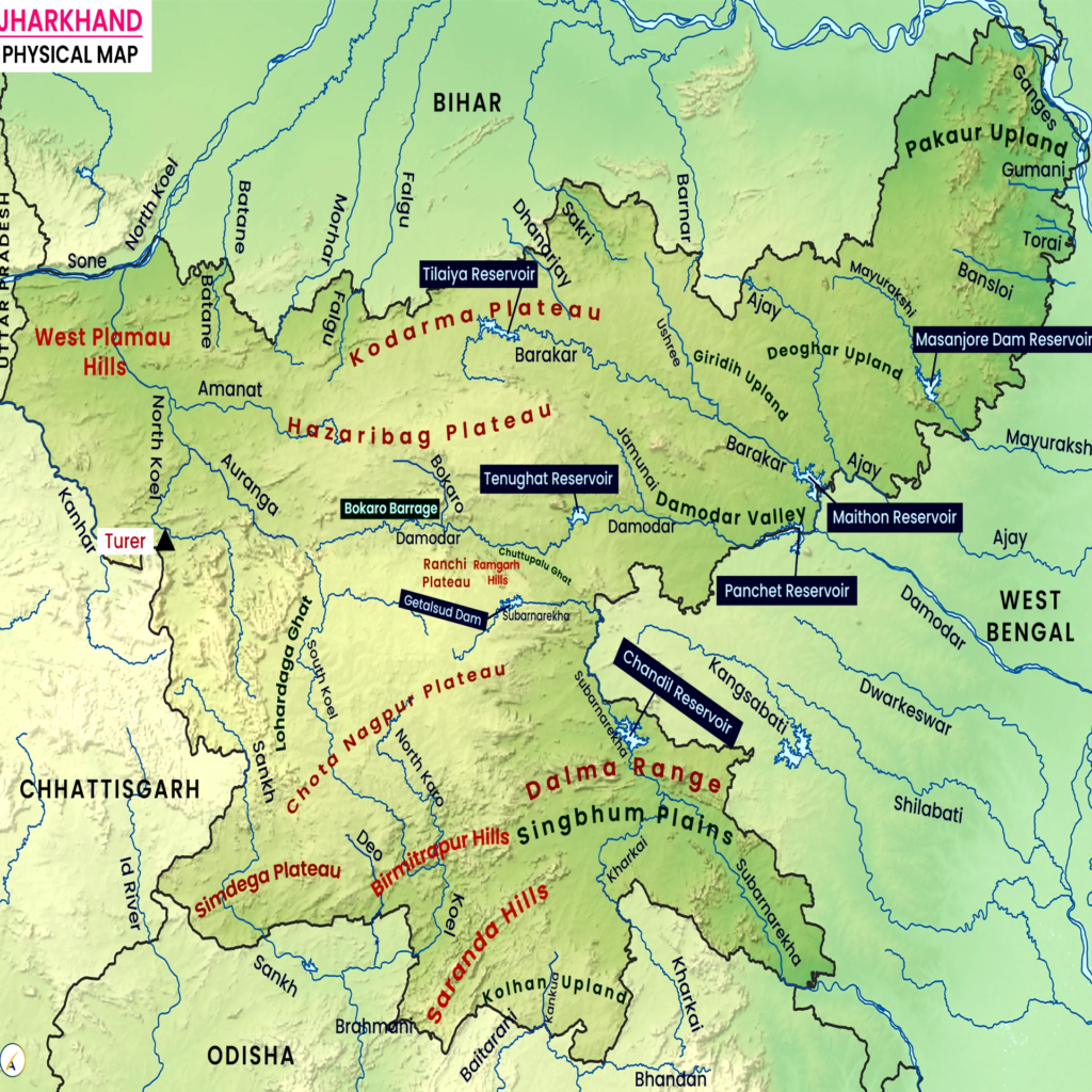
The plateau is especially important because it forms a major drainage divide of Jharkhand. The Subarnarekha, South Koel and several smaller rivers and tributaries originate in or around its elevated surface and flow in different directions. Its sharply dissected margins produce some of Jharkhand’s best-known waterfalls, including Hundru, Dassam and Jonha, while its interior depressions contain important agricultural land and dense rural settlements.
The Ranchi Plateau should therefore be studied not merely as the land on which the state capital stands. It is a complete geographical region whose relief, drainage, waterfalls, soils, climate, forests, agriculture, minerals and settlement pattern have strongly influenced the development of central Jharkhand.
For the wider collection of state-specific material, see JPSC Notes.
Ranchi Plateau at a Glance
| Feature | Important Information |
|---|---|
| Physiographic region | Central Chotanagpur Plateau |
| General elevation | Approximately 600–700 m |
| Elevation of Ranchi city | Around 650 m |
| Dominant rocks | Granite-gneiss and other ancient crystalline rocks |
| Major river | Subarnarekha |
| Other important drainage | South Koel, Kanchi and smaller streams |
| Major waterfalls | Hundru, Dassam, Jonha |
| Dominant soils | Red and yellow soils; lateritic soils in places |
| Natural vegetation | Tropical deciduous forest |
| Characteristic tree | Sal |
| Major agricultural crop | Paddy |
| Major urban centre | Ranchi |
| Important surrounding districts | Ranchi, Khunti and adjoining plateau areas |
| Major geographical character | Elevated dissected plateau with waterfalls and agricultural depressions |
Location of the Ranchi Plateau
The Ranchi Plateau lies in central Jharkhand and forms one of the principal surfaces of the Chotanagpur Plateau system. Ranchi district occupies its central portion, while extensions of the plateau continue into adjoining Khunti, Lohardaga and neighbouring areas.
Physiographically, the plateau lies below the higher western Pat region but above many of the lower basins and valleys to the north and east. It therefore occupies an intermediate level within Jharkhand’s characteristic stepped plateau landscape.
Its broad position can be understood as:
- Western side: transition towards Lohardaga and higher Pat country;
- Northern side: descent towards the Damodar basin and lower North Chotanagpur terrain;
- Eastern side: gradual descent towards lower Subarnarekha drainage;
- Southern side: transition towards Khunti and the South Koel drainage region.
This location gives the Ranchi Plateau exceptional importance as both a watershed and central settlement region.

Geological Structure of the Ranchi Plateau
The Ranchi Plateau is built largely upon ancient Precambrian crystalline rocks. Granite, gneiss and associated metamorphic rocks form much of its geological foundation. These rocks are extremely old and belong to the ancient Indian Peninsular Shield.
Over very long periods, chemical weathering and erosion reduced the original surface and produced a broad plateau. Later uplift and river incision dissected this surface, creating the valleys, ridges and escarpments visible today.
The geological sequence can be broadly understood as:
Ancient crystalline basement
↓
Long period of weathering and denudation
↓
Development of broad erosion surface
↓
Later uplift and river incision
↓
Present dissected Ranchi Plateau
The physical appearance of the plateau is therefore the result of both ancient rock structure and prolonged erosion.
Relief of the Ranchi Plateau
The Ranchi Plateau is often described as broadly level, but this does not mean that its surface is completely flat. Most of the plateau is gently undulating, with low ridges separating shallow valleys and agricultural depressions.
Typical relief features include:
- broad uplands;
- low residual hills;
- shallow depressions;
- stream valleys;
- rocky outcrops;
- steep peripheral escarpments.
The central parts of the plateau generally have gentler relief, while the margins are more deeply dissected.
This distinction is important because different economic activities occupy different parts of the landscape. Agriculture concentrates in valleys and depressions, settlements favour relatively level surfaces, and forests survive more extensively on hill slopes and rocky land.
Elevation of the Ranchi Plateau
Much of the Ranchi Plateau lies between approximately 600 and 700 metres above mean sea level. Ranchi city itself is situated at roughly 650 metres, although individual localities vary.
The plateau is therefore considerably higher than:
- the Damodar basin;
- much of the lower eastern plateau;
- several northern valleys.
However, it is lower than:
- the Netarhat Plateau;
- major western Pats;
- Parasnath Hill.
Broad Altitudinal Comparison
| Region | Approximate Geographical Character |
|---|---|
| Western Pats/Netarhat | Mostly around 900–1,100 m in major high surfaces |
| Ranchi Plateau | Mostly around 600–700 m |
| Damodar Valley | Generally lower structural basin |
| Peripheral eastern valleys | Lower plateau and valley surfaces |
| Parasnath | About 1,365 m at summit |
This stepped arrangement is one of the defining features of Jharkhand physiography.
Why Ranchi Has a Relatively Moderate Climate
Altitude has a significant influence on the climate of Ranchi. Despite being situated within tropical latitudes, Ranchi generally experiences lower temperatures than many lower-elevation areas of Jharkhand.
The principle is straightforward:
Increasing elevation → decreasing temperature
Consequently, Ranchi generally has comparatively milder summer conditions than places located in lower basins such as Palamu.
Elevation also affects:
- night temperature;
- winter cooling;
- evaporation;
- local humidity;
- wind conditions.
This is one reason Ranchi historically emerged as an attractive administrative centre.
Ranchi Plateau as a Drainage Divide
One of the most important geographical functions of the Ranchi Plateau is its role as a water divide. Rivers originating on different parts of the plateau flow towards separate drainage systems.
The principal systems are:
Eastern Drainage
The Subarnarekha River flows generally eastward and ultimately reaches the Bay of Bengal.
Southern and South-Western Drainage
The South Koel system drains parts of the plateau towards the south-west and eventually contributes to the Brahmani drainage system.
This means that a relatively small geographical area around Ranchi supplies water to river systems flowing in completely different directions.
Subarnarekha River and the Ranchi Plateau
The Subarnarekha River originates near the Ranchi plateau region and forms the principal river associated with the plateau. It initially flows through a relatively gentle upland landscape before encountering abrupt changes in elevation.
Where the river descends sharply from the plateau, it creates Hundru Falls, one of Jharkhand’s most spectacular waterfalls. The river later flows towards the Singhbhum region and ultimately reaches the Bay of Bengal.
Its course therefore links:
Ranchi Plateau
↓
Waterfall zone
↓
Singhbhum industrial region
↓
Lower eastern drainage
The Subarnarekha is therefore both a physical and economic artery.
South Koel Drainage
The South Koel River is another major river associated with the broader Ranchi plateau region. It drains areas towards the south-west and eventually joins the Sankh system to form part of the Brahmani River system.
The existence of the Subarnarekha and South Koel systems on opposite sides of the plateau demonstrates the importance of Ranchi as a watershed.
This drainage pattern also influences agriculture because villages depend heavily on local streams, tanks and groundwater rather than a single large river system.
Kanchi River
The Kanchi River is an important tributary within the Subarnarekha drainage system. It is especially famous for forming Dassam Falls.
The river flows across hard crystalline rocks of the Ranchi Plateau before descending sharply over a rock step. This produces a multi-stream waterfall rather than a simple vertical plunge.
Dassam therefore provides an excellent example of the relationship between:
Rock resistance + plateau gradient + river erosion = waterfall formation
Waterfalls of the Ranchi Plateau
The Ranchi Plateau contains the greatest concentration of famous waterfalls in Jharkhand. Their presence is directly linked to the plateau’s stepped relief and resistant crystalline rocks.
The three most important are:
| Waterfall | River | Physical Association |
|---|---|---|
| Hundru Falls | Subarnarekha | Eastern edge/descent of Ranchi Plateau |
| Dassam Falls | Kanchi | Plateau river descending over resistant rocks |
| Jonha Falls | Raru River system | Plateau escarpment and steep valley descent |
These waterfalls are geomorphological evidence that the Ranchi Plateau stands above adjoining lower surfaces.
Hundru Falls
Hundru Falls is formed by the Subarnarekha River as it descends from the Ranchi Plateau. The fall is approximately 98 metres, making it one of the highest and most famous waterfalls of Jharkhand.
The waterfall lies roughly east of Ranchi and demonstrates the steep difference between the plateau surface and lower terrain.
Its geographical importance lies in:
- plateau geomorphology;
- river erosion;
- tourism;
- local ecological value.
During the monsoon, discharge increases sharply, while the flow becomes considerably lower during the dry season.
Dassam Falls
Dassam Falls, also known locally as Dassam Ghagh, is formed by the Kanchi River, a tributary of the Subarnarekha. The waterfall lies south-east of Ranchi in the broader plateau region.
The river divides into several channels as it moves over the rocky edge, producing its characteristic appearance. The waterfall has a height of roughly 44 metres.
Dassam demonstrates how even relatively small plateau rivers can form major waterfalls when they encounter sharp topographical breaks.
Jonha Falls
Jonha Falls, also known as Gautamdhara, lies in the Ranchi plateau region and is associated with the Raru River system. The waterfall develops where the river descends sharply into a lower valley.
Unlike some purely vertical waterfalls, Jonha has a more stepped or hanging-valley character.
Its geographical importance is increased by:
- surrounding forest;
- steep valley slopes;
- tourism;
- religious associations.
Escarpments of the Ranchi Plateau
An escarpment is a steep slope separating two levels of land. The margins of the Ranchi Plateau contain several such steep slopes.
Escarpments are important because they influence:
- waterfalls;
- road alignment;
- erosion;
- river gradients;
- settlement patterns.
Roads connecting Ranchi with lower regions frequently have to negotiate these changes in elevation.
This produces winding routes and steep gradients in several directions from the plateau.
Soils of the Ranchi Plateau
The soils are largely derived from weathering of granite-gneiss and related crystalline rocks. The dominant soils are red and yellow soils, with lateritic soils occurring on some more highly weathered uplands.
Important characteristics include:
- generally acidic reaction;
- relatively low organic matter in many uplands;
- low natural fertility compared with deep alluvial soils;
- susceptibility to erosion;
- considerable local variation in depth.
Soil quality changes substantially according to topographic position.
Upland, Middle Land and Lowland Soils
One of the most important features of Ranchi Plateau agriculture is the local classification of fields according to relief.
Upland Fields
These occupy higher positions and lose water quickly.
Typical characteristics:
- shallow soils;
- rapid drainage;
- lower moisture;
- greater erosion risk.
Middle Lands
These occur along gentle slopes and receive some runoff from the uplands.
They generally have:
- moderate soil depth;
- better moisture conditions;
- mixed cropping potential.
Lowlands
These occupy depressions and valley bottoms.
They have:
- deeper soils;
- greater moisture retention;
- accumulation of fine sediments;
- high suitability for paddy.
This topographic arrangement strongly controls agriculture.
Agriculture of the Ranchi Plateau
Rice or paddy is the dominant crop in suitable low-lying fields. The monsoon supplies most of the water needed for cultivation, and consequently crop performance depends heavily on the timing and distribution of rainfall.
Other crops include:
- maize;
- pulses;
- millets;
- oilseeds;
- vegetables.
Vegetable cultivation has considerable importance around Ranchi because of proximity to a large urban market and favourable climatic conditions in several parts of the plateau.
Agricultural Land Pattern
A typical plateau village may contain a sequence such as:
Rocky/forest upland
↓
Dry agricultural upland
↓
Middle field
↓
Moist valley
↓
Paddy lowland
This pattern may repeat several times across the gently undulating surface.
Consequently, a village may experience both drought-prone fields and waterlogged fields within a relatively small area.
Rainfed Agriculture
Large parts of the Ranchi Plateau remain dependent on monsoon rainfall. Even though annual rainfall can be substantial, the plateau loses large quantities of water through rapid surface runoff.
The principal constraints include:
- seasonal rainfall;
- undulating terrain;
- shallow upland soils;
- limited water storage;
- uneven irrigation.
This produces a recurring geographical paradox:
High monsoon rainfall but seasonal water shortage
The solution lies largely in improved storage and watershed management rather than rainfall alone.
Tanks, Ponds and Water Harvesting
Traditional settlements on the Ranchi Plateau developed numerous small ponds, tanks and local water-storage structures because streams become much smaller during the dry season.
Modern water management increasingly relies on:
- farm ponds;
- check dams;
- reservoirs;
- contour trenches;
- watershed treatment;
- groundwater recharge.
These methods attempt to slow down monsoon runoff and retain water within the landscape.
Getalsud Reservoir
The Getalsud Reservoir, constructed on the Subarnarekha River near Ranchi, is one of the most important water-storage structures serving the plateau region.
It supports:
- urban water supply;
- water storage;
- local fisheries;
- regional water management.
Its presence illustrates the growing importance of reservoirs for rapidly urbanising Ranchi.
Climate of the Ranchi Plateau
The Ranchi Plateau has a tropical monsoon climate modified significantly by elevation. Summers are warm but generally less severe than those of lower western and northern valleys, while winters can become distinctly cool.
The climatic year can broadly be divided into:
| Season | Months | General Condition |
|---|---|---|
| Summer | March–May | Warm to hot |
| Monsoon | June–September | Wet and humid |
| Post-monsoon | October–November | Decreasing rainfall, pleasant temperatures |
| Winter | December–February | Cool and dry |
The elevated setting also produces substantial daily temperature variation during winter.
Rainfall
Most rainfall is received from the south-west monsoon between June and September. Annual totals commonly exceed 1,000 mm, but rainfall varies from year to year.
More important than the annual total is its distribution. Long dry spells during the monsoon can damage paddy even if total seasonal rainfall ultimately approaches normal levels.
The success of farming therefore depends on:
- monsoon onset;
- rainfall frequency;
- dry-spell duration;
- water-storage capacity.
Natural Vegetation
The original natural vegetation of the Ranchi Plateau belongs mainly to the tropical deciduous forest type. Sal is the characteristic tree and remains widespread in forest patches around the plateau.
Other common species include:
- mahua;
- kendu;
- palash;
- kusum;
- bamboo.
The distribution of forest has been significantly modified by agriculture, urbanisation, roads and settlement expansion.
Sal Forests
Sal (Shorea robusta) is particularly well adapted to the climatic and soil conditions of the Chotanagpur Plateau. It forms both pure and mixed forest stands.
Sal forests provide:
- timber;
- leaves;
- fuelwood;
- habitat;
- soil protection.
They also have significant economic and cultural importance for local communities.
Forest Distribution around the Plateau
Better-preserved forests tend to occur on:
- hill slopes;
- rocky uplands;
- less accessible areas;
- watershed zones.
More level central areas have experienced greater conversion to agriculture and urban settlement.
This again demonstrates the influence of relief on land use.
Ranchi Plateau and Tribal Settlement
The Ranchi Plateau has historically been a major settlement region of indigenous communities, particularly the Munda and Oraon, alongside other communities of central Jharkhand.
Traditional villages developed around a combination of:
- agricultural lowlands;
- forest patches;
- water sources;
- grazing areas;
- common lands.
The plateau’s physical geography therefore shaped not only economic activity but also social organisation and customary land systems.
For broader background on indigenous communities, see Tribes of Jharkhand.
Traditional Settlement Pattern
Many older villages developed on slightly elevated ground close to agricultural valleys rather than directly within waterlogged lowlands.
Such locations offered:
- protection from seasonal flooding;
- access to cultivated fields;
- nearby water;
- connection to forest resources.
The traditional settlement pattern therefore reflects careful adaptation to local micro-relief.
Ranchi as an Urban Centre
Ranchi is by far the largest and most important urban centre on the plateau. Its development was influenced by several geographical advantages.
These include:
- relatively moderate climate;
- central location;
- comparatively level plateau surface;
- water availability;
- administrative importance;
- regional transport connections.
Ranchi’s designation as the capital of Jharkhand in 2000 accelerated urban expansion.
Urban Expansion of Ranchi
Urban growth has spread beyond the traditional city towards surrounding rural and peri-urban areas. Residential colonies, educational institutions, commercial developments and transport infrastructure now occupy substantial parts of the former agricultural landscape.
This has created geographical problems such as:
- reduction of open land;
- loss of ponds and wetlands;
- increased runoff;
- traffic congestion;
- groundwater stress;
- conversion of agricultural land.
The plateau’s urban geography is therefore changing rapidly.
Ranchi Plateau and Industrial Development
Unlike Dhanbad or Jamshedpur, Ranchi did not develop primarily because of a single mineral deposit. Its industrial importance is associated more strongly with engineering, administration and regional services.
The development of heavy engineering activities around Ranchi was supported by its proximity to the broader mineral-industrial belt of Jharkhand.
The city’s central location allowed it to connect with:
- Ramgarh coal region;
- Bokaro;
- Jamshedpur;
- Lohardaga;
- other parts of South Chotanagpur.
Mineral Resources of the Plateau Region
The Ranchi Plateau itself is not as strongly associated with large coalfields as the Damodar Valley or iron ore as Singhbhum. However, the surrounding South Chotanagpur region contains several important mineral resources.
The wider region is associated with:
- bauxite towards Lohardaga;
- limestone and other minor minerals in selected areas;
- stone and building materials.
This demonstrates that mineral distribution within Jharkhand follows geological belts rather than administrative boundaries.
Bauxite Connection with the Western Margin
Towards Lohardaga and the western highlands, plateau surfaces become higher and more heavily lateritised. These areas contain important bauxite deposits.
The geographical relationship is:
High old plateau surface
↓
Prolonged tropical weathering
↓
Strong leaching
↓
Concentration of aluminium compounds
↓
Bauxite deposits
This transition links the Ranchi Plateau with the higher Pat region farther west.
Transport Geography
Ranchi occupies a central position within the Jharkhand plateau and functions as an important road and rail node.
Major transport connections extend towards:
- Jamshedpur;
- Bokaro;
- Ramgarh;
- Hazaribagh;
- Lohardaga;
- Khunti;
- Gumla.
However, routes leaving the plateau often encounter steep gradients because they must descend towards lower valleys.
The physical geography therefore has direct consequences for road engineering and transport costs.
Plateau Relief and Roads
On the relatively level plateau surface, roads can follow fairly direct routes. At the plateau margins, however, construction becomes more difficult because of:
- steep slopes;
- rocky terrain;
- river valleys;
- escarpments.
This contrast explains why travel distance does not always correspond closely with straight-line distance in the surrounding highlands.
Ranchi Plateau and Water Supply
Rapid urban growth has significantly increased demand for water. Ranchi depends on a combination of:
- reservoirs;
- surface water;
- groundwater;
- local water-storage systems.
Major reservoirs serving the wider urban region include Getalsud and other water-storage systems.
Groundwater is unevenly distributed because the plateau is underlain largely by hard crystalline rocks. Water occurs mainly in weathered zones, fractures and joints rather than in extensive porous aquifers.
Hard-Rock Groundwater
The hydrogeology of the Ranchi Plateau differs from that of alluvial plains.
In an alluvial aquifer, groundwater can occupy large interconnected pore spaces. On the Ranchi Plateau, water is concentrated mainly in:
- weathered rock;
- fractures;
- joints;
- local structural zones.
Consequently, two nearby wells can have very different yields.
This makes groundwater management particularly important.
Soil Erosion
Soil erosion occurs when heavy monsoon rainfall washes loose soil from exposed slopes and upland fields.
The risk increases where:
- vegetation has been removed;
- cultivation occurs along steep slopes;
- soil remains bare during intense rainfall;
- drainage channels are poorly managed.
The eroded material eventually accumulates in lowlands, streams and reservoirs.
Soil conservation therefore requires treatment across the entire watershed rather than only individual farms.
Environmental Problems of the Ranchi Plateau
Rapid urban growth and modification of natural drainage have created several environmental pressures.
Important issues include:
- loss of forests;
- encroachment on water bodies;
- groundwater stress;
- soil erosion;
- solid-waste disposal;
- river pollution;
- conversion of agricultural land;
- increased surface runoff.
The problem is especially significant because many smaller streams form the headwaters of larger river systems.
Subarnarekha and Urban Pollution
Streams draining Ranchi eventually contribute water to larger rivers, particularly the Subarnarekha system. Urban sewage, solid waste and untreated runoff can therefore affect downstream water quality.
The plateau’s watershed position means that environmental degradation in Ranchi is not only a local problem.
Pollutants can move downstream towards:
- rural settlements;
- reservoirs;
- industrial regions;
- neighbouring districts.
Protecting headwater catchments is therefore particularly important.
Ecological Importance
Despite extensive urban and agricultural development, the plateau retains patches of forests, wetlands and rocky habitats. These landscapes provide important ecological services.
They help:
- recharge groundwater;
- reduce soil erosion;
- regulate runoff;
- maintain biodiversity;
- moderate local temperature.
Preserving connected green spaces becomes increasingly important as Ranchi expands.
Ranchi Plateau and Tourism
Physical geography provides the basis for much of the region’s tourism.
Important geographical attractions include:
- Hundru Falls;
- Dassam Falls;
- Jonha Falls;
- forest landscapes;
- reservoirs;
- plateau viewpoints.
These attractions are all connected with the plateau’s distinctive relief and drainage.
Tourism therefore represents an economic use of the same geomorphological features that determine rivers and waterfalls.
Ranchi Plateau Compared with Other Jharkhand Regions
| Feature | Ranchi Plateau | Western Pats | Damodar Valley | Singhbhum Plateau |
|---|---|---|---|---|
| Typical relief | Broad undulating plateau | High flat-topped uplands | Lower structural basin | Rugged hills and valleys |
| Approximate elevation | ~600–700 m | ~900–1,100 m | Generally lower | Highly variable |
| Major resource | Agriculture, water, urban land | Bauxite, forests | Coal | Iron ore, copper |
| Major river association | Subarnarekha, South Koel | Headwater streams | Damodar-Barakar | Subarnarekha and southern streams |
| Major urban centre | Ranchi | Limited large urbanisation | Dhanbad/Bokaro/Ramgarh | Jamshedpur region |
| Major physical feature | Waterfalls | High plateau surfaces | Gondwana basin | Mineralised highlands |
Relationship between Relief and Land Use
The Ranchi Plateau shows a particularly clear relationship between topography and human use.
Hill/rocky upland → Forest or grazing
Gentle upland → Dry cultivation and settlement
Middle slope → Mixed agriculture
Low depression → Paddy
Urban plateau surface → Ranchi metropolitan development
This vertical sequence demonstrates how small differences in elevation can produce major differences in land use.
Why the Ranchi Plateau Is Geographically Important
The importance of the Ranchi Plateau lies in the way several geographical processes come together within one region.
It serves as:
- an important intermediate plateau surface;
- a drainage divide;
- the source region of major rivers and streams;
- the location of several major waterfalls;
- an important agricultural region;
- a major tribal settlement landscape;
- the site of Jharkhand’s capital and largest administrative centre.
Few other parts of Jharkhand combine such a wide range of physical and human geographical functions.
Ranchi Plateau: Core Data
| Indicator | Key Information |
|---|---|
| General elevation | ~600–700 m |
| Ranchi city elevation | ~650 m |
| Dominant geology | Precambrian crystalline rocks |
| Major river | Subarnarekha |
| Other drainage | South Koel, Kanchi and tributary systems |
| Hundru Falls | Subarnarekha; approximately 98 m |
| Dassam Falls | Kanchi; approximately 44 m |
| Characteristic forest | Sal-dominated tropical deciduous |
| Dominant agricultural crop | Paddy |
| Main soil group | Red and yellow soils |
| Major city | Ranchi |
| Important reservoir | Getalsud |
| Major geographical role | Plateau surface and regional watershed |
Geographical Significance of the Ranchi Plateau
The Ranchi Plateau occupies a central place in Jharkhand geography because its elevated surface controls drainage, waterfalls, agriculture, climate and settlement. Its Precambrian crystalline foundation has been deeply weathered and dissected over geological time, producing an undulating landscape of uplands, valleys and steep margins.
The most characteristic relationship is:
Elevated plateau
↓
Radial drainage
↓
Steep escarpments
↓
Waterfalls
At the same time:
Undulating relief
↓
Upland-lowland soil differences
↓
Variation in soil moisture
↓
Different agricultural land uses
Modern urbanisation has added another layer to this geography. Ranchi has expanded from a plateau settlement into the administrative and service centre of Jharkhand, placing increasing pressure on water, forests, agricultural land and natural drainage.
The Ranchi Plateau is therefore an excellent example of how ancient geology and landforms continue to influence modern economic and urban development.
Frequently Asked Questions (FAQs)
1. Where is the Ranchi Plateau located?
The Ranchi Plateau lies in central Jharkhand and forms an important part of the Chotanagpur Plateau.
2. What is the average elevation of the Ranchi Plateau?
Much of the plateau lies approximately 600–700 metres above mean sea level.
3. What is the approximate elevation of Ranchi city?
Ranchi lies at roughly 650 metres above mean sea level.
4. Which rocks dominate the Ranchi Plateau?
The plateau consists mainly of ancient granite-gneiss and associated Precambrian crystalline rocks.
5. Is the Ranchi Plateau completely flat?
No. It is broadly level but gently undulating and deeply dissected by streams.
6. Why is the Ranchi Plateau important as a watershed?
Rivers originating around the plateau flow towards different systems, especially the Subarnarekha and South Koel.
7. Which is the principal river of the Ranchi Plateau?
The Subarnarekha River is the most important river associated with the plateau.
8. Which river forms Hundru Falls?
Hundru Falls is formed by the Subarnarekha River.
9. What is the approximate height of Hundru Falls?
Hundru Falls is approximately 98 metres high.
10. Which river forms Dassam Falls?
Dassam Falls is formed by the Kanchi River.
11. What is the approximate height of Dassam Falls?
Dassam Falls is approximately 44 metres high.
12. Which river is associated with Jonha Falls?
Jonha Falls is associated with the Raru River system.
13. Why are there several waterfalls near Ranchi?
Rivers flowing from the elevated plateau descend across steep escarpments and resistant rock steps.
14. Which soils dominate the Ranchi Plateau?
Red and yellow soils are widespread, with lateritic soils occurring in some areas.
15. Why are plateau upland soils often less fertile?
They are generally shallower, more strongly leached and more vulnerable to erosion than valley soils.
16. Which crop dominates the lowlands?
Paddy or rice is the principal crop of moisture-retaining lowlands.
17. Which crops are common on uplands?
Maize, pulses, millets and oilseeds are commonly better suited to relatively dry upland conditions.
18. Why does the Ranchi Plateau experience water shortage despite substantial rainfall?
Much monsoon water is lost through rapid surface runoff, while storage and groundwater availability remain uneven.
19. What type of natural vegetation occurs on the Ranchi Plateau?
The natural vegetation is mainly tropical deciduous forest, especially Sal forest.
20. Which tree is characteristic of the plateau?
Sal is one of the dominant and most characteristic trees.
21. Which tribal communities have historically been strongly associated with the Ranchi Plateau?
The Munda and Oraon, among other communities, have long-standing settlements in the region.
22. Why is Ranchi cooler than many lower areas of Jharkhand?
Its elevation of about 650 metres moderates temperature.
23. What is Getalsud Reservoir?
Getalsud is an important reservoir on the Subarnarekha River serving the wider Ranchi region.
24. Why is groundwater unevenly available on the plateau?
The underlying hard crystalline rocks store groundwater mainly in weathered zones, joints and fractures.
25. How does relief affect farming?
Uplands lose water rapidly, whereas lowlands collect runoff and have deeper, wetter soils suitable for paddy.
26. How does the Ranchi Plateau differ from the western Pat region?
The Ranchi Plateau generally lies around 600–700 m, while major western Pats commonly rise around 900–1,100 m.
27. How does it differ from the Damodar Valley?
The Ranchi Plateau is mainly a crystalline upland, whereas the Damodar Valley is a lower Gondwana sedimentary basin containing major coalfields.
28. What are the major environmental challenges of the Ranchi Plateau?
Major problems include urban expansion, groundwater stress, forest loss, soil erosion, water-body encroachment and river pollution.
29. Why is the Ranchi Plateau important economically?
It supports agriculture, tourism and services and contains Ranchi, the administrative and economic centre of Jharkhand.
30. What is the defining geographical feature of the Ranchi Plateau?
Its defining character is that of an elevated, ancient crystalline plateau acting as a drainage divide and producing numerous waterfalls along its dissected margins.





