
The Chotanagpur Plateau is the dominant physiographic region of Jharkhand and one of the most important sections of the Peninsular Plateau of India. It occupies most of Jharkhand and extends into adjoining parts of Odisha, West Bengal and Chhattisgarh. Built largely upon extremely old Precambrian crystalline and metamorphic rocks, the plateau contains several levels of uplands, structural basins, residual hills, escarpments and deeply dissected river valleys rather than one continuous flat surface.
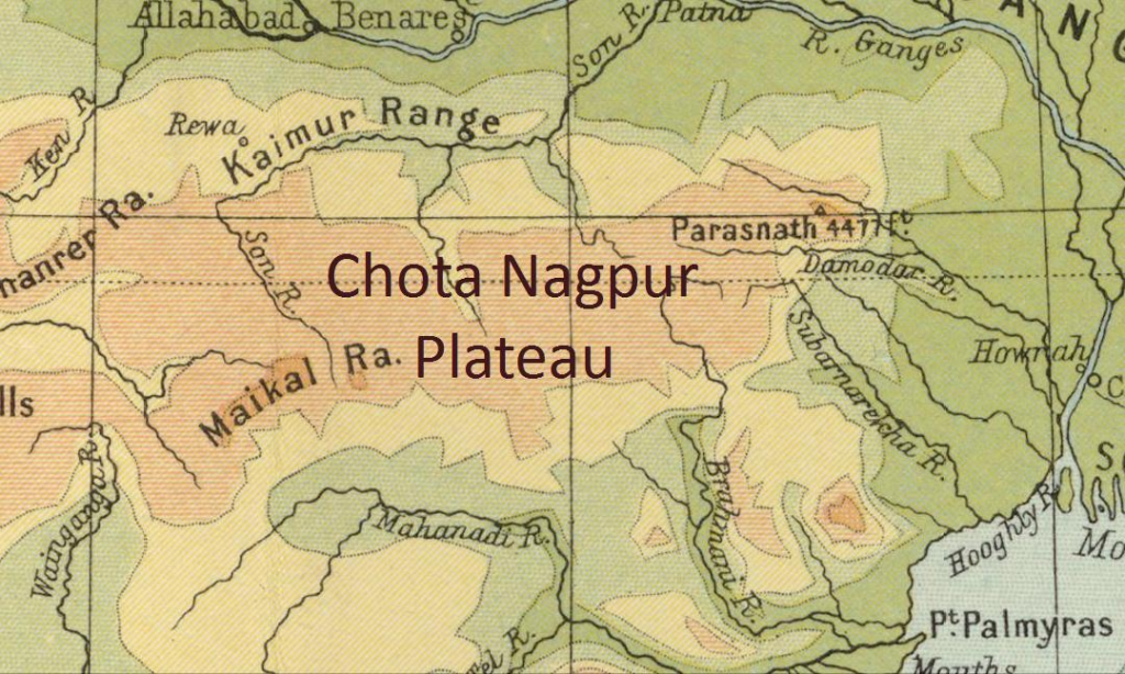
The plateau controls almost every major element of Jharkhand’s geography. The Damodar coalfields, Singhbhum iron-ore belt, western bauxite-bearing Pats, Ranchi waterfalls, Sal forests and major river systems are all closely connected with its geological and geomorphological structure. This relationship between ancient geology, relief and natural resources is why the Chotanagpur Plateau is central to any serious study of Jharkhand Geography.
Chotanagpur Plateau at a Glance
| Feature | Important Information |
|---|---|
| Physiographic division | Eastern part of the Peninsular Plateau |
| Core state | Jharkhand |
| Approximate plateau area | About 65,000 km² in the broader geographical region |
| Dominant rocks | Granite, gneiss, schist, quartzite and other ancient crystalline rocks |
| Geological age of basement | Predominantly Precambrian |
| Highest prominent summit | Parasnath Hill – about 1,365 m |
| Important high plateau | Netarhat and western Pat region |
| Typical Ranchi Plateau elevation | Roughly 600–700 m |
| High Pat surfaces | Commonly around 900–1,100 m |
| Major structural basin | Damodar Valley |
| Major rivers | Damodar, Subarnarekha, North Koel, South Koel, Sankh, Barakar |
| Major coalfields | Jharia, Bokaro, Ramgarh, North Karanpura, South Karanpura |
| Major metallic mineral belt | Singhbhum |
| Characteristic vegetation | Tropical deciduous forest, especially Sal |
The expression Chotanagpur Plateau refers to a broad plateau complex rather than a single level surface. Ranchi, Hazaribagh, Netarhat, Palamu, Singhbhum and the Damodar basin all form different geographical components within this larger plateau system.

Location and Extent of the Chotanagpur Plateau
The Chotanagpur Plateau occupies a large part of eastern-central India, with Jharkhand forming its geographical core. Within Jharkhand it extends from the high western uplands of Latehar, Gumla and Lohardaga across the Ranchi and Hazaribagh plateaus to the Singhbhum uplands in the south and the lower eastern margins towards West Bengal.
Its broader limits can be understood as:
- North: transition towards the Gangetic Plain;
- East: gradual descent towards the Bengal plains;
- South: continuation into the Odisha plateau and mineral belts;
- West: transition towards the highlands of Chhattisgarh.
This central position gives the Chotanagpur Plateau a major watershed role. Rivers originating within the plateau ultimately drain towards the Ganga, Bay of Bengal and Brahmani systems, showing that the region forms an important drainage divide of eastern India.
Geological Foundation
The Chotanagpur Plateau is among the oldest land surfaces of India. Much of its basement consists of Precambrian crystalline and metamorphic rocks such as granite, gneiss, schist and quartzite, which form part of the ancient Indian shield.
These old rocks have undergone repeated phases of tectonic movement, weathering and erosion over an immense geological period. The modern plateau is therefore not simply a block raised once above the surrounding plains; it is the product of a long history of crustal stability interrupted by uplift, faulting and prolonged denudation.
Three contrasting geological landscapes are particularly important:
| Geological Region | Dominant Formation | Geographical Importance |
|---|---|---|
| Ranchi-Hazaribagh uplands | Ancient crystalline rocks | Main plateau surfaces |
| Damodar Valley | Gondwana sedimentary formations | Coalfields |
| Singhbhum region | Very ancient mineralised formations | Iron, copper, uranium |
The volcanic Rajmahal Hills lie to the north-east and are usually treated separately because their basaltic lava geology differs from the crystalline Chotanagpur core.
Formation and Evolution of the Plateau
The basic rock foundation of Chotanagpur is extremely ancient, but the present relief developed through repeated erosion and tectonic adjustments. Long periods of weathering reduced old uplands, while later uplift caused rivers to cut more deeply into the surface.
This produced the characteristic stepped plateau relief visible today. Higher erosion surfaces survived in western Jharkhand, intermediate surfaces developed around Ranchi and Hazaribagh, and structural basins such as the Damodar Valley remained at lower elevations.
The broad sequence can be understood as:
Ancient crystalline basement
↓
Long denudation and weathering
↓
Uplift and faulting
↓
River incision
↓
Present stepped and dissected plateau
This geomorphological history explains why the region contains both broad plateau surfaces and dramatic escarpments.
Three-Level Plateau Structure
One of the most important characteristics of the Chotanagpur Plateau is its multi-level relief. The plateau can broadly be interpreted through high, middle and lower surfaces.
Higher Plateau Surface
The highest extensive plateau surfaces occur mainly in western Jharkhand, particularly in the Pat region. Many important Pats lie approximately between 900 and 1,100 metres, although individual elevations vary.
Important areas include:
- Netarhat;
- Latehar uplands;
- Lohardaga Pats;
- Gumla highlands.
These surfaces are often deeply weathered and lateritic.
Middle Plateau Surface
The Ranchi Plateau represents an important intermediate level and generally lies around 600–700 metres in many areas. The Hazaribagh Plateau also forms an important elevated surface north of the Damodar basin.
These middle-level plateaus contain:
- agricultural depressions;
- rolling terrain;
- residual hills;
- dissected river valleys.
Lower Plateau and Basin Surface
Lower surfaces occur around the Damodar Valley, eastern plateau margins and peripheral basins. These regions generally have gentler slopes and have attracted denser settlement, mining, industries and transport infrastructure.
Ranchi Plateau
The Ranchi Plateau is one of the best-defined physiographic units within Chotanagpur. Its broad surface is gently undulating, but numerous streams have dissected it into ridges, depressions and valleys.
The plateau’s most dramatic features occur along its margins, where rivers suddenly descend to lower surfaces. This produces waterfalls such as Hundru, Dassam and Jonha, which are not isolated scenic features but direct expressions of plateau geomorphology.
Agricultural land also follows local relief. Lower depressions retain moisture and support paddy cultivation, while higher surfaces drain rapidly and tend to support less intensive farming.
Hazaribagh Plateau
The Hazaribagh Plateau lies north of the Damodar Valley and forms another important element of the plateau complex. It consists of rolling uplands, residual hills, forest patches and valleys drained mainly towards the Damodar-Barakar system.
The plateau is physically separated from Ranchi by the lower Damodar structural basin. This produces a clear arrangement in which elevated crystalline surfaces occur on both sides of the coal-bearing valley.
The Hazaribagh region has also been strongly influenced by mining and transport development in neighbouring coalfields. Its valleys provide natural routes through otherwise dissected terrain.
Western Pats
The Pats form the highest extensive surfaces of the Chotanagpur Plateau. They are distinctive flat-topped uplands surrounded by steep scarps and valleys, occurring mainly in Latehar, Lohardaga and Gumla.
The flat upper surfaces have undergone prolonged weathering, producing thick lateritic profiles. In some areas this process concentrated aluminium compounds sufficiently to create bauxite deposits, making the Pats important economically as well as geomorphologically.
Their major characteristics include:
- high elevation;
- broad flat summits;
- steep margins;
- dense or moderate forest cover;
- lateritic soils;
- bauxite-bearing formations.
Netarhat Plateau
The Netarhat Plateau is the best-known high plateau of western Jharkhand and rises to around 1,000 metres or more in important sections. It stands well above many surrounding valleys, which gives it cooler climatic conditions and striking escarpment scenery.
The surface is extensively forested and dissected near its margins. Streams descending from the high plateau have cut deep valleys into surrounding terrain.
Netarhat therefore provides an excellent physical example of the uppermost plateau level of Chotanagpur.
Damodar Valley: Structural Basin within the Plateau
The Damodar Valley interrupts the older crystalline plateau surface and forms one of Chotanagpur’s most important structural basins. Its geological history differs from the surrounding Ranchi and Hazaribagh plateaus because the depression contains thick Gondwana sedimentary formations.
These formations contain the principal coalfields of Jharkhand:
| Coalfield | Broad Location |
|---|---|
| Jharia | Dhanbad region |
| Bokaro | Bokaro region |
| Ramgarh | Ramgarh region |
| North Karanpura | North-western Damodar system |
| South Karanpura | Ramgarh-Hazaribagh belt |
Coal transformed the natural structural basin into India’s major mining-industrial landscape.
The connection is direct:
Structural depression → Gondwana sediments → Coal → Mining → Railways → Heavy industry
Why the Damodar Basin Contains Coal
During the Gondwana geological period, faulted depressions developed within the older plateau. Rivers, lakes and swamp-like environments accumulated thick deposits of sediment and organic vegetation in these troughs.
Burial under additional sediments subjected the plant material to heat and pressure over geological time. This produced extensive coal seams.
The concentration of coal in Jharkhand is therefore controlled by geological structure, not simply by modern administrative boundaries.
Singhbhum Plateau
The Singhbhum Plateau forms the mineral-rich southern part of the Chotanagpur region. Its geology contains some of the oldest and most highly mineralised rocks in India.
The landscape is rugged, with:
- hill ranges;
- narrow valleys;
- forested uplands;
- exposed mineralised rock formations.
Important minerals include iron ore, copper and uranium. The western Singhbhum iron-ore belt has been particularly important for India’s iron and steel industry.
Singhbhum Iron Ore Belt
Major iron-bearing areas occur around the wider Noamundi-Gua-Kiriburu region of West Singhbhum. Ore deposits occur within hills and ridges where mineralised formations are relatively accessible.
The physical landscape consequently combines:
- iron-ore mines;
- forested hills;
- railway corridors;
- tribal settlements.
This close overlap of minerals, forests and communities makes Singhbhum one of Jharkhand’s most environmentally sensitive geographical regions.
Palamu Plateau Region
The Palamu region forms the western and north-western part of the wider Chotanagpur landscape. It is more heavily dissected than the Ranchi Plateau and consists of forested uplands, hills, valleys and relatively dry basins.
The North Koel River forms the principal drainage axis. Agricultural settlement is concentrated more strongly in valleys, while uplands remain comparatively forested.
Palamu’s interior position, high summer temperatures and rainfall variability make it one of the more drought-prone parts of Jharkhand.
Parasnath Hill
Parasnath Hill or Shikharji, located in Giridih district, rises to approximately 1,365 metres and is the highest point of Jharkhand. Unlike the broad western Pats, Parasnath is a prominent isolated highland rising sharply above surrounding plateau surfaces.
Its significance is therefore both:
- physiographic, as the state’s highest summit;
- cultural, as one of Jainism’s most important pilgrimage landscapes.
The hill also supports important forest vegetation because elevation and slopes have restricted intensive settlement.
Escarpments of the Chotanagpur Plateau
An escarpment is a steep slope separating two relatively different levels of land. Escarpments are common around the major plateau surfaces of Jharkhand and are essential for understanding the state’s waterfall geography.
The Ranchi Plateau provides the clearest examples. Rivers flowing across its upper surface suddenly descend along steep margins, producing dramatic waterfalls.
Escarpments also influence:
- road construction;
- drainage;
- erosion;
- settlement location.
Drainage of the Chotanagpur Plateau
The plateau functions as an important regional water divide. Rivers originate on elevated surfaces and flow towards several major drainage systems rather than converging into one river.
The principal rivers are:
- Damodar
- Barakar
- Subarnarekha
- North Koel
- South Koel
- Sankh
For the complete river network, see Drainage System of Jharkhand. (LearnPro)
Drainage Directions
The rivers leave the plateau in different directions.
| River/System | General Drainage Direction | Ultimate System |
|---|---|---|
| Damodar-Barakar | East | Lower Ganga-Hooghly system |
| Subarnarekha | East/South-east | Bay of Bengal |
| North Koel | North | Son-Ganga system |
| South Koel-Sankh | South/South-east | Brahmani system |
This drainage pattern confirms that Chotanagpur acts as a broad watershed region of eastern India.
Damodar River
The Damodar drains the major structural basin between the Ranchi and Hazaribagh plateau systems. Its valley is lower than many surrounding uplands and contains Jharkhand’s most important coalfields.
Important tributaries include:
- Barakar;
- Konar;
- Bokaro.
The river’s modern geography has been extensively modified by dams, reservoirs, mining settlements and industrial development.
Subarnarekha River
The Subarnarekha originates in the Ranchi plateau region and flows generally eastward across Jharkhand. Its upper course demonstrates the influence of plateau relief particularly clearly.
Where the river leaves the elevated Ranchi Plateau, it forms Hundru Falls. Farther downstream it passes through the mineral-industrial landscape of Singhbhum before ultimately reaching the Bay of Bengal.
The river therefore connects three contrasting landscapes:
Ranchi Plateau → Singhbhum industrial belt → coastal drainage
North Koel
The North Koel drains the western Chotanagpur region, especially Palamu. Unlike the Damodar and Subarnarekha, which flow broadly eastward, the North Koel eventually joins the Son River system.
This is an important example of the role played by Chotanagpur as a watershed between different major river basins.
South Koel and Sankh
The South Koel and Sankh drain south-western sections of the plateau. Their combined waters ultimately form part of the Brahmani system flowing through Odisha.
Their valleys pass through some of Jharkhand’s most heavily forested and tribal-dominated landscapes.
Waterfalls and Plateau Relief
Jharkhand’s famous waterfalls are direct products of the Chotanagpur Plateau’s stepped relief.
| Waterfall | River | Physical Cause |
|---|---|---|
| Hundru | Subarnarekha | Descent from Ranchi Plateau |
| Dassam | Kanchi | Sharp break in plateau slope |
| Jonha | Ranchi region | Plateau escarpment |
| Lodh | Western highland | Steep highland descent |
| Hirni | Singhbhum region | Dissected plateau relief |
The large number of waterfalls is therefore evidence of differences in elevation between adjacent plateau surfaces.
Climate of the Plateau
The Chotanagpur Plateau has a tropical monsoon climate modified by elevation. Higher areas such as Ranchi and Netarhat are generally cooler than lower basins such as Palamu and the Damodar Valley.
Most rainfall occurs from June to September under the influence of the south-west monsoon. Much of the broader plateau receives approximately 1,100–1,400 mm of rainfall annually, although totals vary considerably from region to region and from year to year.
Elevation influences:
- summer temperature;
- winter minimum temperature;
- local rainfall;
- evaporation.
This creates substantial climatic variation within Jharkhand despite its relatively compact area.
Temperature and Elevation
The moderating influence of altitude is clearly visible in Ranchi and Netarhat. Lower basins become considerably hotter during summer, while the higher plateaus experience relatively mild daytime conditions and cooler nights.
The basic relationship is:
Higher elevation → lower average temperature
Lower basin → higher summer temperature
This altitudinal effect is especially important when comparing Netarhat, Ranchi and Palamu.
Rainfall and Runoff
The plateau receives substantial monsoon rainfall, but much of that water moves rapidly down slopes and into rivers. Hard rocks, shallow soils and uneven terrain limit infiltration in many upland areas.
The result can be:
Heavy monsoon rainfall → rapid runoff → limited storage → dry-season scarcity
This explains why Jharkhand can experience both intense monsoon runoff and recurring agricultural drought.
Soils of the Chotanagpur Plateau
Most plateau soils have developed through weathering of ancient crystalline rocks.
Major soil groups include:
- red and yellow soils;
- lateritic soils;
- shallow upland soils;
- deeper valley soils.
Soil depth is strongly controlled by relief. Steep slopes tend to have thinner soils because erosion removes weathered material, while valleys accumulate deeper sediment.
Red and Yellow Soils
Red and yellow soils dominate large areas of the plateau. Their colours are associated mainly with iron compounds produced during tropical weathering.
These soils are commonly:
- acidic;
- relatively poor in humus;
- low in nitrogen;
- vulnerable to erosion.
Their productivity depends greatly on moisture availability and nutrient management.
Lateritic Soils
Lateritic soils occur particularly on old, highly weathered plateau surfaces. Heavy rainfall and prolonged chemical weathering remove soluble minerals while leaving iron and aluminium-rich residual material.
This process is especially important in the high western plateau because it is linked with bauxite formation.
Valley Soils
Valleys receive materials eroded from surrounding uplands and generally contain deeper soils with better moisture retention.
Consequently:
Plateau uplands → thinner, drier soils
Valley bottoms → deeper, wetter soils
This produces major differences in agricultural productivity within short distances.
Natural Vegetation
The characteristic natural vegetation of the plateau is tropical deciduous forest, with Sal forming the dominant tree over large areas.
Other important species include:
- mahua;
- kendu;
- palash;
- kusum;
- bamboo.
Forest distribution is strongest in rugged sections of West Singhbhum, Latehar, Gumla, Simdega and Khunti, where steep terrain historically limited agricultural expansion.
Forests and Plateau Relief
There is a strong relationship between forest cover and relief.
Rugged highland → difficult cultivation → greater forest survival
Gentler valley → agricultural expansion → lower forest cover
This helps explain why southern and western plateau districts retain much larger continuous forest landscapes than many coal-industrial regions.
Chotanagpur Plateau and Tribal Settlement
The plateau has historically supported large populations of Munda, Oraon, Ho and other indigenous communities. Forests, upland agriculture, valleys and community land systems shaped settlement over many centuries.
Tribal settlements tended to develop where communities could combine:
- agriculture;
- forest use;
- grazing;
- water sources;
- common land.
For the broader social geography of these communities, see Tribes of Jharkhand. (LearnPro)
Early Settlement and the Plateau
The difficult terrain of Chotanagpur helped preserve distinctive community institutions and settlement patterns. Village societies developed close relationships with particular forests, hills, water sources and agricultural lands.
The plateau therefore cannot be understood purely as a geological feature. It has also shaped Jharkhand’s social geography, customary land systems and political history.
Related historical background is available in Early Tribal Settlements in Chotanagpur Plateau. (LearnPro)
Mineral Resources of the Chotanagpur Plateau
The Chotanagpur Plateau is often described as one of India’s richest mineral regions because several major geological formations occur within a relatively limited geographical area.
Important resources include:
- coal;
- iron ore;
- copper;
- uranium;
- bauxite;
- mica;
- limestone;
- dolomite.
Mineral distribution is highly regional and reflects underlying geology.
Mineral Distribution by Region
| Region | Major Mineral Association |
|---|---|
| Damodar Valley | Coal |
| West Singhbhum | Iron ore |
| Singhbhum Copper Belt | Copper |
| East Singhbhum mineral belt | Uranium |
| Lohardaga-western Pats | Bauxite |
| Koderma-Giridih belt | Mica |
The plateau therefore provides a clear demonstration of the relationship between geology and economic resources.
Chotanagpur Plateau and Coal
The plateau’s coal deposits are concentrated in structural Gondwana basins rather than ancient crystalline surfaces.
Important coalfields include:
- Jharia;
- Bokaro;
- Ramgarh;
- North Karanpura;
- South Karanpura.
These fields collectively transformed the Damodar region into a major national energy and industrial corridor.
Chotanagpur Plateau and Iron Ore
The Singhbhum Iron Ore Belt occupies the southern portion of the plateau complex. Large deposits occur particularly in the hills of West Singhbhum.
Iron ore availability helped create the geographical foundation for Jamshedpur’s steel industry. Coal could be transported from the Damodar region, while iron ore was available from Singhbhum, creating a favourable raw-material combination.
Chotanagpur Plateau and Bauxite
Bauxite is associated mainly with the highly weathered western Pat surfaces, particularly around Lohardaga and adjoining uplands.
The sequence of formation is broadly:
Old plateau surface → intense tropical weathering → strong leaching → aluminium concentration → bauxite
This makes bauxite one of the clearest examples of a mineral directly connected with plateau geomorphology.
Chotanagpur Plateau and Mica
The northern plateau around Koderma and Giridih became historically famous for mica. The deposits occur within pegmatite formations associated with the ancient crystalline rocks.
Although the economic importance of individual mining belts has changed over time, the region remains an important example of mineralisation within the old plateau basement.
Agriculture on the Plateau
Agriculture is shaped by the distinction between upland, middle land and lowland fields. Rice dominates moisture-retaining depressions, while uplands support crops better suited to relatively dry conditions.
A typical pattern is:
| Relief Position | Moisture | Common Agricultural Use |
|---|---|---|
| Upper upland | Low | Millets, pulses, maize |
| Middle slope | Moderate | Mixed seasonal crops |
| Lowland valley | High | Paddy |
This explains why even neighbouring fields may have very different productivity.
Why Agriculture Remains Rainfed
Large parts of the plateau remain heavily dependent on monsoon rainfall because its geomorphology makes extensive irrigation difficult. Rivers often flow through incised channels below agricultural surfaces, while steep gradients encourage rapid runoff.
The main constraints include:
- uneven terrain;
- shallow soils;
- seasonal rivers;
- dispersed fields;
- limited groundwater in hard-rock areas.
Consequently, ponds, tanks, check dams and watershed structures are especially important.
Settlement Pattern
Settlement is uneven across the Chotanagpur Plateau. Densely populated areas tend to occur where fertile valleys, mineral resources or industries create favourable conditions.
Three important settlement types can be distinguished:
Agricultural Settlements
Concentrated in valleys and gentler plateau surfaces.
Forest-Tribal Settlements
Common in southern and western uplands.
Mining-Industrial Settlements
Highly concentrated in the Damodar and Singhbhum belts.
The modern population pattern therefore reflects both physical geography and resource geography.
Industrial Development
Few plateau regions in India show such a strong relationship between geology and industry.
The development chain is clear:
Coal in Damodar
Iron ore in Singhbhum
Water resources
Railways
↓
Steel, power, engineering and mining industries
Major industrial centres include:
- Jamshedpur;
- Dhanbad;
- Bokaro;
- Ramgarh.
The Chotanagpur Plateau consequently became one of India’s principal heavy-industrial regions.
Transport and Relief
Plateau relief initially created major obstacles to transport. Steep gradients, forests and dissected valleys made construction expensive.
Railways therefore followed natural corridors where possible, especially:
- Damodar Valley;
- mining belts;
- river valleys;
- lower plateau passes.
Later industrial expansion produced a dense railway network linking coalfields, mines and steel plants.
Environmental Importance
The plateau contains extensive forests, river catchments, wildlife habitats and mineral resources within the same landscape. This overlap generates serious environmental conflicts.
Major issues include:
- mining-related deforestation;
- soil erosion;
- river pollution;
- mine fires;
- land subsidence;
- habitat fragmentation;
- human-elephant conflict.
The problem is especially severe where high-value mineral deposits occur underneath forested and tribal landscapes.
Chotanagpur Plateau and Jharkhand’s Economic Geography
Jharkhand’s economy can be understood largely through the plateau.
Damodar basin → Coal economy
Singhbhum → Iron and steel economy
Western Pats → Bauxite economy
Ranchi Plateau → Administrative and service economy
Forested uplands → Forest-based livelihoods
The physical subdivisions of the plateau therefore correspond closely with different economic regions.
Regional Comparison
| Plateau Region | Approximate Character | Major Economic Association |
|---|---|---|
| Western Pats | High, flat-topped, lateritic | Bauxite, forests |
| Ranchi Plateau | 600–700 m broad upland | Agriculture, administration |
| Hazaribagh Plateau | Dissected northern plateau | Agriculture, coal-belt proximity |
| Damodar Valley | Lower structural basin | Coal, power, industry |
| Palamu | Dry dissected plateau | Agriculture, forests |
| Singhbhum | Rugged mineral highland | Iron, copper, mining |
Geographical Significance of the Chotanagpur Plateau
The Chotanagpur Plateau is the geographical foundation of Jharkhand. Its ancient geology created mineral deposits, its stepped relief produced river systems and waterfalls, its soils influenced agriculture, and its rugged terrain helped preserve extensive forests.
Its significance can be summarised through six major relationships:
- Ancient rocks → mineral wealth
- Stepped relief → waterfalls
- Highland drainage divide → multiple river systems
- Rugged terrain → forest persistence
- Valleys → agriculture and settlement
- Coal + iron → heavy industrialisation
The Chotanagpur Plateau is therefore not merely one landform among many. It is the central geographical framework within which Jharkhand’s physical environment, natural resources, population distribution and economic development have evolved.
Frequently Asked Questions (FAQs)
1. What is the Chotanagpur Plateau?
The Chotanagpur Plateau is a large ancient plateau complex of eastern India forming the principal physical region of Jharkhand.
2. Which state contains the largest part of the Chotanagpur Plateau?
Jharkhand forms the geographical core of the plateau.
3. Is the Chotanagpur Plateau a single flat surface?
No. It contains high Pats, middle plateaus, structural basins, residual hills, valleys and escarpments.
4. Which rocks mainly form the Chotanagpur Plateau?
Much of the plateau consists of ancient granite, gneiss, schist, quartzite and related crystalline and metamorphic rocks.
5. What is the geological age of the plateau basement?
Much of the basement is Precambrian, making it part of the ancient Indian shield.
6. What are the major subdivisions of the Chotanagpur Plateau?
Important subdivisions include the Ranchi Plateau, Hazaribagh Plateau, western Pat region, Damodar Valley, Palamu region and Singhbhum Plateau.
7. What are Pats?
Pats are high, relatively flat-topped plateau surfaces found particularly in western Jharkhand.
8. What is the approximate elevation of the western Pats?
Many important Pat surfaces lie roughly around 900–1,100 metres.
9. What is the approximate elevation of the Ranchi Plateau?
Much of the Ranchi Plateau lies approximately around 600–700 metres.
10. Which is the highest point of Jharkhand?
Parasnath Hill or Shikharji, at about 1,365 metres, is the highest point.
11. Why does the Chotanagpur Plateau have many waterfalls?
Rivers cross steep escarpments and move from higher plateau surfaces to lower levels, producing waterfalls.
12. Which major waterfalls occur on the plateau?
Important examples include Hundru, Dassam, Jonha, Hirni and Lodh Falls.
13. Which major rivers drain the plateau?
The principal rivers include the Damodar, Subarnarekha, North Koel, South Koel, Sankh and Barakar.
14. Why is the Chotanagpur Plateau an important watershed?
Its elevated surfaces send rivers towards several different systems, including the Ganga, Subarnarekha and Brahmani drainage systems.
15. Why is the Damodar Valley different from the surrounding plateau?
It is a structural basin containing Gondwana sedimentary rocks, whereas much of the surrounding plateau consists of ancient crystalline formations.
16. Why is the Damodar Valley rich in coal?
Ancient structural depressions accumulated vegetation and sediments that were later transformed into coal.
17. Which are the major coalfields of the plateau?
Important coalfields include Jharia, Bokaro, Ramgarh, North Karanpura and South Karanpura.
18. Where is iron ore concentrated?
Major iron-ore deposits occur in the Singhbhum Iron Ore Belt, particularly in West Singhbhum.
19. Why is bauxite found on the western Pats?
Intense tropical weathering and leaching on old plateau surfaces concentrated aluminium-rich residual material.
20. Which region is famous for mica?
The Koderma-Giridih belt is historically associated with mica.
21. What is the dominant natural vegetation?
The plateau is characterised largely by tropical deciduous forest, particularly Sal forest.
22. Which parts of the plateau contain extensive forests?
Major forest landscapes occur in West Singhbhum, Latehar, Gumla, Simdega and Khunti.
23. Why are valleys more suitable for agriculture?
They contain deeper soils and retain more moisture than upland slopes.
24. What is the major crop in the lowlands?
Paddy or rice dominates suitable moisture-retaining lowlands.
25. Why is much of the plateau agriculture rainfed?
Uneven relief, rapid runoff, hard-rock geology and limited irrigation make agriculture highly dependent on monsoon rainfall.
26. How has the plateau influenced tribal settlement?
Its forests, valleys, common lands and relative isolation supported long-established indigenous settlement and customary land systems.
27. How did the plateau influence industrialisation?
The combination of Damodar coal and Singhbhum iron ore created the resource base for heavy industry.
28. Which major industrial cities developed on or around the plateau?
Important centres include Jamshedpur, Dhanbad, Bokaro, Ranchi and Ramgarh.
29. What are the major environmental problems of the Chotanagpur Plateau?
Important issues include mining-related land degradation, deforestation, soil erosion, river pollution, mine fires, subsidence and habitat fragmentation.
30. Why is the Chotanagpur Plateau important to Jharkhand?
It forms the fundamental geographical structure underlying Jharkhand’s relief, drainage, forests, minerals, agriculture, settlement and industrial economy.





