
The climate of Jharkhand is broadly classified as tropical monsoon climate, but the state shows considerable regional variation because of differences in altitude, relief, forest cover, latitude and distance from moisture-bearing winds. The elevated Chotanagpur Plateau, deep river valleys, forested western highlands and lower eastern districts create noticeable contrasts in temperature and rainfall across the state.
Jharkhand experiences three clearly marked climatic seasons—summer, south-west monsoon and winter, with short transitional periods between them. Summers are generally hot and dry, the monsoon provides most of the annual rainfall between June and September, and winters are cool and comparatively dry. Plateau stations such as Ranchi and Netarhat remain considerably cooler than lower regions such as Palamu and parts of the Damodar Valley.
For a wider understanding of the physical setting controlling the state’s climate, see JPSC Notes..
Key Climatic Features of Jharkhand
| Feature | Description |
|---|---|
| Predominant Climate Type | Sub-tropical with significant monsoon influence; Tropical Monsoon Climate (Köppen Aw/Cwg) |
| Latitudinal Position | 21°58′ to 25°18′ North latitude (Tropical Zone) |
| Average Plateau Elevation | 600-700 meters (Chota Nagpur Plateau) |
| Primary Monsoon Source | Southwest Monsoon (Bay of Bengal branch) |
| Monsoon Arrival (Typical) | Second week of June |
| Monsoon Withdrawal (Typical) | Mid-October |
| Average Annual Rainfall | 1100-1400 mm |
| Summer Temperature Range | 30°C to 38°C (max often > 40°C) |
Jharkhand does not have a uniform climate. Temperature may differ substantially between a high plateau location and a nearby lower valley, while rainfall also varies from eastern and southern forest regions to the relatively drier north-west.
Factors Controlling the Climate of Jharkhand
Jharkhand’s climate is controlled by several geographical factors acting together. The most important are latitude, altitude, relief, monsoon circulation, continentality and vegetation cover.
The state lies largely between about 22° N and 25° N latitude, placing it within the tropical-subtropical transition zone. However, latitude alone cannot explain its climatic pattern because much of Jharkhand stands several hundred metres above sea level.
The most important controls are:
- Latitude
- Altitude
- Chotanagpur Plateau relief
- South-West Monsoon
- Distance from the Bay of Bengal
- Forest cover
- Local river valleys and basins
Among these, altitude and monsoon rainfall are particularly important.
Get all JPSC Notes https://learnpro.in/jpsc-notes/

Role of Altitude
Much of Jharkhand lies on the Chotanagpur Plateau, and this elevated position moderates temperature over large areas. The Ranchi Plateau generally lies around 600–700 metres, while Netarhat and the western high plateaus rise to around 900–1,100 metres in important sections.
As elevation increases, temperature generally decreases.
This produces the basic pattern:
Netarhat and high Pats → cooler
Ranchi and Hazaribagh plateaus → moderate
Palamu and lower valleys → hotter
This explains why Ranchi often experiences milder summers than lower-elevation areas at similar latitude.
Role of the Chotanagpur Plateau
The plateau affects climate in several ways. It changes the movement of moisture-bearing winds, creates local differences in rainfall and produces major temperature contrasts between high surfaces and valleys.
Relief affects:
- wind direction;
- cloud formation;
- rainfall distribution;
- surface runoff;
- local humidity.
The Physiographic Divisions of Jharkhand therefore provide the physical framework for understanding the state’s climate.
Influence of the South-West Monsoon
The south-west monsoon is the principal source of rainfall in Jharkhand. Moisture-bearing winds generally reach the state after moving inland from the Bay of Bengal.
The monsoon usually becomes established during June and remains active through September. The majority of annual rainfall is concentrated within these four months.
Monsoon rainfall is extremely important because it determines:
- paddy cultivation;
- reservoir storage;
- groundwater recharge;
- forest moisture;
- stream discharge.
A delayed or weak monsoon can therefore have immediate economic consequences.
Distance from the Sea
Jharkhand is a landlocked state, so it does not receive the same maritime moderation as coastal Odisha or West Bengal.
As a result, the state experiences a relatively greater annual temperature range.
The contrast is particularly visible between:
- hot pre-monsoon summers;
- cool winter nights.
The interior western districts show stronger continental influence than the eastern parts of the state.
Role of Forest Cover
Forests locally moderate temperature and humidity. Heavily forested regions of West Singhbhum, Latehar, Gumla and Simdega generally have different local climatic conditions from densely built urban and mining areas.
Forests influence:
- evapotranspiration;
- soil moisture;
- surface temperature;
- local humidity;
- rainfall infiltration.
Loss of forest cover can therefore increase surface heating and reduce the ability of the landscape to retain monsoon water.
Seasons of Jharkhand
The climatic year can broadly be divided into four periods:
| Season | Approximate Period |
|---|---|
| Winter | December–February |
| Summer/Pre-Monsoon | March–May |
| South-West Monsoon | June–September |
| Post-Monsoon/Retreating Monsoon | October–November |
Each season has a distinctive temperature, rainfall and wind pattern.
Summer Season in Jharkhand
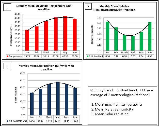
Summer generally begins in March and becomes most intense during April and May. Temperatures rise rapidly as the sun moves northward and dry continental conditions become dominant.
May is usually among the hottest months.
Lower western districts such as:
- Palamu;
- Garhwa;
- parts of Latehar;
often experience very high temperatures.
Plateau regions such as Ranchi remain comparatively moderate because of altitude.
Summer Temperature
Maximum temperatures in the hotter lowland and valley regions may rise above 40°C during severe heat conditions.
By contrast, high plateau areas usually remain several degrees cooler.
The temperature pattern can broadly be expressed as:
| Region | Summer Character |
|---|---|
| Palamu-Garhwa | Very hot |
| Damodar basin | Hot |
| Ranchi Plateau | Moderately hot |
| Netarhat highlands | Comparatively mild |
Local temperature varies from year to year, but the influence of elevation remains consistent.
Hot Winds and Dry Conditions
During April and May, hot dry winds may affect parts of Jharkhand, especially the western and northern regions.
These winds increase:
- evaporation;
- soil moisture loss;
- heat stress;
- forest fire risk.
The period before the monsoon is therefore often the most difficult for agriculture and water availability.
Pre-Monsoon Thunderstorms
Summer is not completely dry. Local convection can produce thunderstorms, strong winds and short-duration rainfall, particularly during April and May.
These storms may temporarily reduce temperature and provide moisture to vegetation.
They can also produce:
- lightning;
- hail in some cases;
- strong gusty winds.
Lightning is an important weather hazard during the pre-monsoon and monsoon seasons.
South-West Monsoon Season
The south-west monsoon generally reaches Jharkhand during June. Rainfall increases rapidly after monsoon onset and remains high through July and August.
The season extends broadly from:
June → July → August → September
These four months provide the majority of Jharkhand’s annual rainfall.
The monsoon determines the agricultural calendar of the state.
Monsoon Rainfall
Much of Jharkhand receives broadly around 1,100–1,400 mm of annual rainfall, although regional and annual variations are substantial.
Some areas receive more than this broad range, while relatively dry western parts may receive less.
Rainfall is influenced by:
- monsoon strength;
- depressions from the Bay of Bengal;
- local relief;
- forest cover;
- position within the plateau.
Rainfall distribution is therefore more important than the state average alone.
Bay of Bengal Depressions
Low-pressure systems and depressions forming over the Bay of Bengal frequently move inland during the monsoon.
When such systems pass near Jharkhand, they can produce:
- widespread rain;
- heavy rainfall;
- strong winds;
- local flooding.
Several days of rainfall may occur when a monsoon depression remains active over eastern India.
This makes Bay of Bengal systems particularly important for Jharkhand’s seasonal rainfall.
July and August
July and August are generally among the wettest months.
During this period:
- rivers carry higher discharge;
- reservoirs fill;
- agricultural fields receive maximum water;
- groundwater recharge increases.
Paddy cultivation depends heavily on adequate rainfall during this period.
Monsoon Breaks
Even during the rainy season, Jharkhand can experience monsoon breaks—periods when rainfall becomes weak for several days or even longer.
This is particularly damaging to rainfed agriculture.
A season may receive nearly normal total rainfall but still cause crop losses if rain falls irregularly.
Thus:
Total rainfall is important
but
rainfall distribution is equally important.
Post-Monsoon Season
The monsoon begins withdrawing during October. Rainfall decreases and humidity gradually falls.
October and November form a transitional period between the rainy season and winter.
Temperatures become more pleasant as:
- cloud cover decreases;
- nights become cooler;
- atmospheric humidity falls.
Occasional rain may still occur from cyclonic systems originating in the Bay of Bengal.
Winter Season in Jharkhand
Winter generally extends from December to February. January is usually the coldest month.
The season is characterised by:
- clear skies;
- dry air;
- cool days;
- cold nights.
The effect of winter is strongest on high plateau surfaces.
Winter Temperature
Ranchi, Hazaribagh, Netarhat and other high-elevation areas may experience distinctly cool winter nights.
Netarhat can become particularly cold because of its elevation.
Lower regions remain warmer, but even there night temperatures fall significantly compared with summer.
The difference between daytime and nighttime temperatures may become considerable during clear winter conditions.
Cold Waves
Cold waves originating from northern India occasionally affect Jharkhand.
During such periods:
- minimum temperatures fall sharply;
- frost-like conditions may occur locally in exposed highland areas;
- morning fog can become common.
The north-western and central plateau districts may experience stronger winter cooling than some lower eastern areas.
Western Disturbances
Western disturbances primarily affect north-western India, but their influence can occasionally extend into eastern India.
Jharkhand may receive:
- light winter rain;
- cloud cover;
- falling daytime temperatures.
Such rainfall is limited compared with monsoon rainfall but may benefit winter crops.
Regional Climatic Divisions of Jharkhand
Jharkhand can broadly be divided into several climatic regions based on relief and rainfall.
1. Western Hot and Relatively Dry Region
Includes much of:
- Palamu;
- Garhwa;
- western Latehar.
Characteristics:
- high summer temperatures;
- relatively lower rainfall;
- frequent drought stress;
- strong continentality.
2. Central Plateau Region
Includes:
- Ranchi;
- Hazaribagh;
- Ramgarh;
- parts of Khunti.
Characteristics:
- moderate temperatures;
- significant monsoon rainfall;
- cooler winters;
- strong altitude effect.
3. Southern Forested Region
Includes:
- West Singhbhum;
- Simdega;
- Gumla;
- southern Khunti.
Characteristics:
- substantial forest cover;
- relatively humid conditions;
- moderate to high rainfall;
- lower temperature in highland areas.
4. Eastern and North-Eastern Region
Includes:
- Deoghar;
- Jamtara;
- Dumka;
- Pakur;
- Sahibganj.
Characteristics:
- warmer and more humid;
- lower elevation in many areas;
- greater influence of moisture-bearing eastern weather systems.
Climatic Contrast: Ranchi and Palamu
The contrast between Ranchi and Palamu illustrates the influence of altitude and relief.
| Feature | Ranchi | Palamu |
|---|---|---|
| Elevation | High plateau | Lower basin/plateau |
| Summer | Comparatively moderate | Very hot |
| Winter | Cool | Cool but warmer daytime |
| Rainfall | Moderate to relatively high | Lower and more variable |
| Drought risk | Moderate | High |
Palamu is therefore one of the most drought-prone regions of the state.
Climatic Contrast: Netarhat and Damodar Valley
Netarhat lies on one of Jharkhand’s highest plateau surfaces, while the Damodar Valley forms a much lower structural basin.
Netarhat
- cooler;
- more forested;
- greater altitude;
- milder summer.
Damodar Valley
- warmer;
- more urbanised and industrialised;
- lower elevation;
- stronger heat accumulation in built-up areas.
This demonstrates how local relief modifies regional climate.
Rainfall Distribution in Jharkhand
Rainfall is not evenly distributed throughout the state.
Broadly:
- southern and eastern forested regions tend to receive higher rainfall;
- central plateau areas receive moderate to high rainfall;
- north-western Jharkhand is relatively drier.
Relief and monsoon pathways create local differences.
The highest rainfall may occur where moist winds are lifted over uplands, while leeward or interior regions may receive comparatively less.
Why Palamu Is Drier
Palamu’s relative dryness is linked to several factors:
- inland location;
- local relief;
- weaker access to moisture-bearing winds;
- high summer temperature;
- high evapotranspiration.
The region frequently experiences agricultural water stress.
This is why irrigation and water conservation have particular importance in western Jharkhand.
Rainfall and Agriculture
Agriculture in Jharkhand remains strongly dependent on rainfall.
The principal crop, paddy, requires sufficient moisture during:
- transplantation;
- vegetative growth;
- flowering;
- grain formation.
A prolonged dry spell during any of these stages can reduce yields.
The relationship is:
Good monsoon → better paddy production
Weak or irregular monsoon → agricultural stress
This dependence makes rainfall one of the most important economic variables in the state.
Monsoon and Paddy Cultivation
Most paddy fields are concentrated in lowlands where runoff from higher areas accumulates.
The plateau agricultural landscape follows:
Upland → rapid drainage
Middle land → moderate moisture
Lowland → maximum moisture accumulation
During the monsoon, lower fields retain water and become suitable for rice cultivation.
This links climate directly with relief and agriculture.
Drought in Jharkhand
Jharkhand frequently experiences meteorological and agricultural drought, particularly when monsoon rainfall is delayed or uneven.
Drought may result from:
- late onset of monsoon;
- long dry spells;
- early withdrawal;
- low reservoir storage;
- inadequate irrigation.
The western districts are generally more vulnerable.
Drought does not necessarily mean complete absence of rain. Even short rainfall deficits during critical crop stages can cause severe agricultural damage.
Flooding and Heavy Rainfall
Although Jharkhand is mainly a plateau state, intense monsoon rainfall can cause local flooding in river valleys and low-lying urban areas.
Flood risk is greater where:
- drainage channels are blocked;
- rivers receive sudden high runoff;
- wetlands have been encroached upon;
- urban surfaces prevent infiltration.
Mining areas can also experience local waterlogging because natural drainage has been modified.
Climate and River Flow
Most rivers of Jharkhand show strong seasonal fluctuations because their discharge depends heavily on monsoon rainfall.
During the monsoon:
- rivers swell;
- waterfalls become powerful;
- reservoirs receive inflow.
During summer:
- smaller rivers shrink;
- seasonal streams may dry;
- groundwater becomes more important.
For the broader hydrological pattern, see Drainage System of Jharkhand.
Climate and Waterfalls
Jharkhand’s waterfalls are highly seasonal.
During July and August, waterfalls such as:
- Hundru;
- Dassam;
- Jonha;
- Lodh;
carry much greater discharge.
During late winter and summer, flow decreases significantly.
Thus, waterfall discharge reflects the monsoon-controlled river regime.
Climate and Forests
Jharkhand’s tropical deciduous forests are adapted to a strongly seasonal climate.
Trees experience:
wet monsoon
followed by
long dry season
Many deciduous species shed leaves during dry months to reduce water loss.
Sal is the most characteristic tree of large parts of the state.
Forest Fires and Summer Climate
The dry period from late winter to early summer creates favourable conditions for forest fires.
Risk increases because of:
- dry leaf litter;
- high temperature;
- low humidity;
- strong winds.
Human activities frequently provide the ignition source.
Climate therefore has a direct influence on forest management.
Climate and Soil Formation
Temperature and rainfall influence weathering and soil formation.
Heavy seasonal rainfall promotes:
- chemical weathering;
- leaching;
- development of red and yellow soils;
- laterisation in suitable uplands.
The high western Pats, for example, experienced prolonged tropical weathering that contributed to lateritic soils and bauxite formation.
Climate and Laterisation
Laterisation becomes strong where high temperature and seasonal heavy rainfall cause intense chemical weathering.
The process involves:
High temperature
Heavy rainfall
↓
Leaching of soluble minerals
↓
Concentration of iron and aluminium
↓
Laterite formation
The climate of Jharkhand therefore played a direct role in the development of some of its important soil and mineral landscapes.
Climate and Bauxite
The association between bauxite and the western high plateaus is partly climatic.
Long-term tropical weathering of old plateau surfaces led to strong leaching.
This concentrated aluminium-bearing material and contributed to bauxite formation, especially around Lohardaga and adjoining Pat regions.
Climate, geology and geomorphology therefore work together in mineral formation.
Humidity
Relative humidity is highest during the monsoon season.
The seasonal pattern is generally:
Summer → lower humidity except before storms
Monsoon → high humidity
Post-monsoon → gradually decreasing humidity
Winter → relatively dry atmosphere
Eastern districts generally experience more humid conditions than the dry western interior.
Fog
Fog occurs mainly during winter mornings, particularly:
- in valleys;
- near reservoirs;
- over moist agricultural land.
It is generally short-lived and disappears as temperatures rise.
High plateau areas can also experience low cloud and mist during the monsoon.
Thunderstorms
Thunderstorms occur during both the pre-monsoon and monsoon periods.
They are associated with:
- rapid atmospheric convection;
- intense short-duration rainfall;
- gusty winds;
- lightning.
Jharkhand’s plateau environment frequently experiences strong convective activity during the hot season.
Lightning Hazard
Lightning is a significant natural hazard in Jharkhand.
Thunderstorms occur frequently during:
- April;
- May;
- monsoon months.
Rural populations are particularly vulnerable because many people work outdoors in agriculture and forest areas.
Lightning safety awareness is therefore an important component of disaster preparedness.
Heat Waves
Heat waves particularly affect lower-elevation and western districts.
Vulnerable areas include:
- Palamu;
- Garhwa;
- parts of Chatra;
- lower Damodar basin towns.
Urban areas can experience additional heating because buildings, roads and industrial surfaces absorb and release heat.
Urban Heat Island Effect
Large urban and industrial areas such as:
- Ranchi;
- Jamshedpur;
- Dhanbad;
- Bokaro;
can experience a local urban heat island effect.
Built surfaces:
- absorb more solar radiation;
- reduce natural evapotranspiration;
- retain heat after sunset.
Loss of vegetation and water bodies can intensify this effect.
Mining and Local Climate
Large mining landscapes can influence local environmental conditions through:
- vegetation removal;
- exposed dark rock surfaces;
- dust;
- altered drainage;
- reduced soil moisture.
Open-cast mines may become very hot during summer.
While mining does not determine the regional monsoon climate, it can significantly modify the local microclimate.
Climate Change in Jharkhand
Climate change is increasing concern about:
- rising temperatures;
- heat waves;
- irregular monsoon rainfall;
- intense rainfall events;
- drought;
- forest stress.
The main challenge for Jharkhand is not simply whether total rainfall increases or decreases. Greater rainfall variability can itself create major problems.
For the state’s climate-policy response, see Jharkhand State Action Plan on Climate Change.
Increasing Rainfall Variability
A more variable monsoon can produce both:
long dry periods
and
short bursts of very heavy rainfall
within the same season.
This creates two simultaneous problems:
- crops suffer during dry spells;
- heavy rain produces rapid runoff rather than useful soil moisture.
Water-storage infrastructure therefore becomes increasingly important.
Climate Change and Agriculture
Agriculture is one of the sectors most vulnerable to climatic variability because much of Jharkhand’s farming is rainfed.
Potential impacts include:
- delayed sowing;
- crop failure;
- increased irrigation demand;
- pest outbreaks;
- reduced productivity.
Diversification towards:
- pulses;
- millets;
- drought-resistant crops;
- horticulture
can reduce vulnerability.
Climate Change and Forests
Changing temperature and rainfall patterns can affect:
- forest regeneration;
- fire frequency;
- invasive species;
- wildlife movement;
- water availability.
Forest fragmentation further reduces the ability of ecosystems to adapt.
Protecting large connected forest landscapes is therefore an important climate adaptation measure.
Climate and Human-Wildlife Conflict
Drought and changing water availability can influence wildlife movement.
Elephants may move farther in search of:
- water;
- food;
- connected forest habitat.
This can increase encounters with farms and villages.
For the broader environmental context, see Elephant Corridors and Human-Wildlife Conflict in Jharkhand.
Climate and Groundwater Recharge
Most groundwater recharge occurs during the monsoon.
However, Jharkhand’s hard-rock geology means water is stored mainly in:
- weathered zones;
- fractures;
- joints.
Heavy rainfall falling too quickly may run off before sufficient infiltration occurs.
Watershed treatment is therefore essential to increase groundwater recharge.
Climate and Reservoirs
Reservoirs play a major role in storing monsoon water for use during the dry season.
Important benefits include:
- drinking water;
- irrigation;
- industry;
- power generation.
Reservoir levels depend heavily on monsoon rainfall.
A poor monsoon can therefore create water stress months later.
Water Conservation and Climate
Because rainfall is strongly seasonal, water conservation is one of the most important climatic adaptations for Jharkhand.
Useful measures include:
- check dams;
- farm ponds;
- contour trenches;
- percolation structures;
- watershed treatment;
- restoration of traditional tanks.
These structures convert short-duration monsoon rainfall into longer-term water availability.
Climate and Rural Livelihoods
The rural economy remains highly sensitive to climate because households depend on:
- agriculture;
- livestock;
- forests;
- local water sources.
A drought can simultaneously reduce:
- crop output;
- fodder availability;
- forest products;
- drinking water.
Climate variability therefore has a wider livelihood impact than agriculture alone.
Climate and Tribal Communities
Many tribal communities live in forested and rainfed agricultural regions.
Climate variability affects:
- crop production;
- forest produce;
- water sources;
- livestock.
Traditional knowledge of forests, crops and seasonal water sources remains important for adaptation.
For broader demographic and social context, see Tribes of Jharkhand.
Climatic Regions of Jharkhand: Comparative Table
| Region | Temperature | Rainfall | Climatic Character |
|---|---|---|---|
| Palamu-Garhwa | Highest summer temperatures | Relatively lower | Hot and drought-prone |
| Ranchi Plateau | Moderate | Moderate-high | Pleasant plateau climate |
| Netarhat | Lowest among major plateau areas | Moderate-high | Cool highland climate |
| Hazaribagh | Moderate | Moderate | Plateau climate |
| Singhbhum | Warm-humid | Relatively high in many areas | Forested tropical monsoon |
| Santhal Pargana | Warm | Moderate-high | Humid eastern monsoon climate |
| Damodar Valley | Hot | Moderate | Industrial basin climate |
Temperature Distribution
Temperature generally decreases with elevation.
The broad pattern is:
Lower western and northern basins → hottest
Intermediate plateaus → moderate
High western plateaus → coolest
Local urbanisation can modify this natural pattern.
Thus, Ranchi may be cooler than nearby lower regions, while dense urban development within Ranchi itself can create warmer local microclimates.
Rainfall and Altitude
Rainfall does not increase uniformly with altitude, but elevated terrain can encourage uplift of moisture-bearing air.
The amount received depends on:
- wind direction;
- slope orientation;
- local relief;
- monsoon depression tracks.
Therefore, two places at similar elevations can still receive different rainfall.
Why Jharkhand Is Vulnerable to Climate Variability
Jharkhand has several geographical characteristics that increase its vulnerability:
- Large dependence on rainfed agriculture.
- Strong concentration of rainfall within four months.
- Hard-rock groundwater systems.
- Rapid runoff from plateau surfaces.
- Large rural and forest-dependent population.
- Drought-prone western districts.
- Increasing urbanisation and mining.
The state therefore faces both water excess during the monsoon and water scarcity during the dry season.
Climate and Damodar Industrial Belt
The Damodar Valley contains dense concentrations of:
- coal mines;
- thermal power plants;
- steel industries;
- urban settlements.
These activities can influence local air quality and surface temperature.
Industrial emissions do not create the monsoon climate, but they affect:
- local atmospheric pollution;
- visibility;
- particulate concentration;
- heat stress.
Climatic and environmental problems therefore overlap strongly in the Damodar belt.
Climate and Jharia Coalfield
The Jharia coalfield presents a particularly unusual local environment because underground coal fires and exposed mining surfaces generate additional heat.
This creates:
- extreme local ground temperatures;
- smoke;
- air pollution;
- unstable land.
These conditions are localised and should not be confused with the regional climate, but they significantly affect human habitability.
Climate and Ranchi
Ranchi has traditionally been recognised for its comparatively moderate climate.
Its climatic advantages arise from:
- elevation around 600–700 m;
- plateau position;
- seasonal monsoon rainfall.
However, rapid urbanisation has reduced vegetation and increased built-up surfaces.
The result is a gradual increase in local heat stress, particularly during summer.
Climate and Netarhat
Netarhat represents the clearest example of highland climate modification in Jharkhand.
Its elevation of around 1,000 metres produces:
- cooler summers;
- colder winter nights;
- mist and cloud during wet periods.
This is why Netarhat developed as an important hill tourism destination.
Climate and Palamu
Palamu represents the opposite climatic extreme.
The region experiences:
- very hot summers;
- relatively lower and variable rainfall;
- recurring drought;
- high evapotranspiration.
This makes water conservation and drought-resistant agriculture particularly important.
Climate and Singhbhum
Southern Jharkhand, particularly West Singhbhum, combines forest cover, hill relief and monsoon rainfall.
The region is generally more humid than the dry north-west.
Dense forests locally moderate temperature and improve moisture retention.
Mining and deforestation, however, can reduce these benefits.
Climate and Santhal Pargana
The north-eastern districts have a warmer, relatively humid climate.
Areas such as:
- Dumka;
- Pakur;
- Sahibganj;
receive strong monsoon influence.
The Rajmahal Hills create additional local variation through slope and elevation.
Natural Hazards Related to Climate
Jharkhand faces several climate-related hazards:
- drought;
- heat waves;
- lightning;
- thunderstorms;
- heavy rainfall;
- local floods;
- forest fires.
Among these, drought and lightning are particularly important for rural communities.
Climate Adaptation Priorities
A climate-resilient Jharkhand requires measures that address both water scarcity and excessive runoff.
Important priorities include:
- watershed development;
- rainwater harvesting;
- drought-resistant crops;
- forest restoration;
- improved reservoir management;
- heat-action planning;
- urban green spaces;
- protection of wetlands;
- improved weather forecasting.
These measures can reduce vulnerability without depending on a single large infrastructure solution.
Climate of Jharkhand: Core Data Table
| Indicator | Key Information |
|---|---|
| Climate | Tropical monsoon |
| Main rainy season | June–September |
| Broad annual rainfall | Approximately 1,100–1,400 mm in much of the state |
| Hottest period | April–May |
| Coldest period | December–January |
| Hot region | Palamu-Garhwa |
| Cool plateau region | Ranchi-Hazaribagh |
| Coolest major highland | Netarhat |
| Rainfall source | South-West Monsoon |
| Major rainfall mechanism | Bay of Bengal monsoon systems/depressions |
| Major agricultural risk | Monsoon variability |
| Major summer hazard | Heat waves, thunderstorms and forest fires |
| Major monsoon hazard | Heavy rainfall, lightning and local floods |
| Major climatic challenge | Seasonal water scarcity |
Geographical Significance of Jharkhand’s Climate
The climate of Jharkhand cannot be understood independently of its plateau relief. The interaction of tropical latitude, monsoon circulation and altitude creates a climatic pattern that varies sharply over short distances.
The main geographical relationships are:
Plateau elevation → moderate temperature
Monsoon rainfall → paddy agriculture
Steep relief → rapid runoff
Rapid runoff → seasonal water scarcity
Dry summer → forest-fire and drought risk
Irregular monsoon → agricultural vulnerability
These relationships explain why water management is one of the most important developmental challenges of the state.
Jharkhand therefore presents a distinctive climatic paradox: it receives substantial monsoon rainfall, yet large areas remain vulnerable to drought and dry-season water shortage. Managing this contrast through watershed development, forest conservation and improved water storage is central to the state’s long-term environmental and agricultural security.
Frequently Asked Questions (FAQs)
1. What type of climate does Jharkhand have?
Jharkhand has a tropical monsoon climate modified strongly by plateau elevation.
2. What are the main seasons in Jharkhand?
The main seasons are summer, south-west monsoon, post-monsoon and winter.
3. Which months are the hottest in Jharkhand?
April and May are generally the hottest months.
4. Which months are the coldest?
December and January are usually the coldest.
5. When does Jharkhand receive most of its rainfall?
Most rainfall occurs between June and September.
6. What is the main source of rainfall?
The south-west monsoon, particularly moisture-bearing systems from the Bay of Bengal.
7. What is the approximate annual rainfall of Jharkhand?
Much of the state broadly receives around 1,100–1,400 mm annually, although rainfall varies considerably by region and year.
8. Which part of Jharkhand is relatively hot and dry?
The Palamu-Garhwa region is among the hottest and relatively driest parts of the state.
9. Which part of Jharkhand has a cooler climate?
The Netarhat and other high western plateau areas have a relatively cool climate.
10. Why is Ranchi cooler than many other cities of eastern India?
Ranchi lies on an elevated plateau around 600–700 metres above sea level.
11. Why is Netarhat cooler than Ranchi?
Netarhat lies at a considerably higher elevation, around 1,000 metres in its major plateau areas.
12. Why is Palamu hotter?
Palamu lies at lower elevation and has stronger continental and dry conditions.
13. Which months receive the highest rainfall?
July and August generally receive the heaviest monsoon rainfall.
14. What causes heavy monsoon rainfall in Jharkhand?
Moisture-bearing monsoon winds and low-pressure systems or depressions from the Bay of Bengal are important causes.
15. Why does Jharkhand experience drought?
Drought may result from delayed monsoon, irregular rainfall, long dry spells and limited irrigation.
16. Which region is especially drought-prone?
The Palamu-Garhwa belt is particularly drought-prone.
17. Why does Jharkhand face water scarcity despite substantial rainfall?
Much monsoon rainfall is lost through rapid runoff over plateau slopes, while water-storage capacity remains limited.
18. What are monsoon breaks?
Monsoon breaks are periods of reduced rainfall during the rainy season.
19. Why are monsoon breaks harmful?
They can damage rainfed crops during critical growth stages.
20. Which crop is most dependent on monsoon rainfall?
Paddy or rice is the principal monsoon-dependent crop.
21. What type of storms occur before the monsoon?
Jharkhand commonly experiences convective thunderstorms with strong winds and lightning.
22. Is lightning a major hazard in Jharkhand?
Yes. Lightning is an important seasonal natural hazard.
23. Does Jharkhand receive winter rainfall?
Yes, occasional light winter rainfall may occur under the influence of western disturbances.
24. What type of forest is associated with Jharkhand’s climate?
The dominant natural vegetation is tropical deciduous forest.
25. Why do many trees shed leaves during summer?
Deciduous trees shed leaves to reduce water loss during the dry season.
26. How does climate influence laterite formation?
High temperatures and seasonal heavy rainfall promote intense chemical weathering and leaching.
27. How is climate connected with bauxite?
Long-term tropical weathering of high plateau surfaces contributed to bauxite formation in western Jharkhand.
28. What are the major climate-related hazards of Jharkhand?
Important hazards include drought, heat waves, lightning, thunderstorms, heavy rainfall, local floods and forest fires.
29. How can Jharkhand reduce climate vulnerability?
Important measures include rainwater harvesting, watershed management, forest conservation, drought-resistant crops and improved water storage.
30. What is the most important feature of Jharkhand’s climate?
The most important feature is the combination of a tropical monsoon regime with strong modification by the Chotanagpur Plateau, producing major differences in temperature, rainfall and water availability across the state.





