
Jharkhand Geography : Jharkhand is a landlocked state of eastern India occupying about 79,714 km². Its geographical identity is dominated by the Chotanagpur Plateau, one of the oldest and most mineral-rich sections of the Peninsular Plateau. Ancient crystalline rocks, Gondwana sedimentary basins, volcanic formations, dissected plateaus, forested hills, waterfalls and mineral belts together create a remarkably varied physical landscape within a relatively compact state.
Jharkhand’s geography has directly shaped its economy and society. The Damodar Valley became the centre of coal mining and heavy industry, the Singhbhum region developed around iron ore and other metallic minerals, the forested western and southern plateau supported important tribal settlements, while river valleys and low-lying depressions became the principal zones of agriculture. Thus, relief, geology, forests, rivers, minerals, agriculture, population and industry in Jharkhand are closely interconnected rather than separate geographical themes.
Jharkhand: Basic Geographical Profile
| Indicator | Jharkhand |
|---|---|
| Geographical area | 79,714 km² |
| State formation | 15 November 2000 |
| Capital | Ranchi |
| Districts | 24 |
| Population – Census 2011 | 3.30 crore approximately |
| Population density – 2011 | 414 persons per km² |
| Scheduled Tribe share – 2011 | 26.21% |
| Dominant physiographic unit | Chotanagpur Plateau |
| Highest point | Parasnath Hill – about 1,365 m |
| Principal coal region | Damodar Valley |
| Major metallic mineral belt | Singhbhum |
| Principal forest formation | Tropical deciduous forest |
| Characteristic forest tree | Sal |
| Major crop | Rice/Paddy |
| Major river systems | Damodar, Subarnarekha, Koel, Sankh, Barakar |
For detailed demographic patterns, the Jharkhand Population Statistics page covers population growth, literacy, rural-urban composition and district-level demographic differences.

Click here to get Details of 15th JPSC Foundation Batch
Location and Boundaries of Jharkhand
Jharkhand lies in eastern India and occupies a strategic transitional position between the Middle Ganga Plain in the north and the Peninsular Plateau in the south. The state’s central position in eastern India has historically connected the plains of Bihar and Bengal with Odisha and the forested interior of central India.
Jharkhand shares its boundaries with five states:
- Bihar – north
- West Bengal – east
- Odisha – south
- Chhattisgarh – west
- Uttar Pradesh – north-west
The state is completely landlocked. Its geographical position nevertheless provides important rail and road connections between eastern India’s mineral-producing interior and major industrial and urban markets.
Physiographic Structure of Jharkhand
The Chotanagpur Plateau forms the physical core of the state, but long geological evolution has broken it into a number of separate surfaces. Faulting, uplift, erosion and river incision have produced a stepped landscape in which high plateaus alternate with lower basins and valleys.
The major physiographic regions are:
| Physiographic Region | Principal Characteristics |
|---|---|
| Ranchi Plateau | Broad central plateau with numerous waterfalls |
| Hazaribagh Plateau | Northern upland adjoining Damodar basin |
| Pat Region | High flat-topped western plateaus |
| Netarhat Plateau | High western plateau and forested upland |
| Damodar Valley | Structural basin containing major coalfields |
| Palamu Region | Dissected western plateau and North Koel basin |
| Singhbhum Plateau | Rugged mineral-rich southern plateau |
| Dalma Hills | Forested hill belt near Jamshedpur |
| Rajmahal Hills | Volcanic uplands of north-eastern Jharkhand |
The state’s elevation generally varies from low river valleys and peripheral plains to high plateau surfaces exceeding 1,000 metres in selected western and eastern uplands.
Chotanagpur Plateau
The Chotanagpur Plateau is part of the ancient Indian Peninsular Shield. Its foundation consists largely of very old crystalline and metamorphic rocks that have undergone repeated cycles of uplift, erosion and weathering.
Rather than forming one uninterrupted tableland, the plateau contains several erosion surfaces at different elevations. Rivers have cut deeply into these surfaces, creating valleys, waterfalls and escarpments. This is why Jharkhand’s physical landscape appears highly undulating even in areas described as plateau.
The plateau influences:
- river direction;
- waterfall formation;
- soil depth;
- forest distribution;
- agricultural suitability;
- settlement density;
- transport routes.
Ranchi Plateau
The Ranchi Plateau forms one of the most recognisable physical regions of Jharkhand. Ranchi city is situated on this plateau, whose average surface generally lies around 600–700 metres above mean sea level, though local elevations vary considerably.
The plateau is deeply dissected by streams belonging mainly to the Subarnarekha and South Koel systems. Where these rivers descend over sharp plateau edges, spectacular waterfalls have formed. Hundru, Dassam and Jonha are among the best-known examples.
The Ranchi Plateau contains both upland surfaces and fertile depressions. Low-lying fields retain more monsoon water and are used extensively for paddy cultivation, while higher fields have thinner soils and greater dependence on rainfall.
Hazaribagh Plateau
The Hazaribagh Plateau lies north of the Ranchi Plateau and forms an important component of North Chotanagpur. Its surface is characterised by rolling uplands, isolated hills, valleys and patches of forest.
The plateau stands between the northern plains and the Damodar basin. Numerous streams originating in the uplands eventually drain towards the Damodar and Barakar systems. Its proximity to major coalfields has also strongly influenced the modern settlement and transport geography of the region.
Hazaribagh’s physical geography illustrates the transition from older crystalline uplands to the sedimentary basins that contain Jharkhand’s major coal reserves.
Pat Region and Western High Plateaus
Western Jharkhand contains distinctive flat-topped uplands locally known as Pats. These occur particularly in Latehar, Gumla and Lohardaga and represent some of the highest preserved plateau surfaces in the state.
The Pats usually have relatively level summits but steep margins. Long periods of tropical weathering have produced lateritic surfaces, and some high plateau areas contain economically important bauxite deposits.
Typical characteristics include:
- elevations commonly approaching or exceeding 900 metres in important highland zones;
- deeply weathered surfaces;
- forested slopes;
- red and lateritic soils;
- steep escarpments.
Netarhat Plateau
The Netarhat Plateau is among the most prominent sections of Jharkhand’s western highlands. It lies at considerably greater elevation than many surrounding valleys and consequently experiences a noticeably cooler local climate.
Netarhat represents a preserved high-level plateau surface with steep margins and deeply dissected surroundings. Forests remain important across the region, while the elevated relief produces extensive viewpoints over adjoining valleys and lower plateaus.
Its significance is therefore geomorphological as well as climatic. Netarhat clearly demonstrates the multi-level or stepped structure of the Chotanagpur Plateau.
Damodar Valley
The Damodar Valley is the most economically important structural basin of Jharkhand. Unlike the surrounding ancient crystalline plateau, large parts of the valley contain Gondwana sedimentary formations deposited in structural troughs.
These sedimentary basins contain the state’s great coalfields:
- Jharia
- Bokaro
- Ramgarh
- North Karanpura
- South Karanpura
The concentration of coal transformed the Damodar Valley into an industrial corridor containing mines, thermal power stations, railway networks and major urban centres.
Palamu Plateau and Basin
The Palamu region occupies western and north-western Jharkhand and consists of dissected plateau surfaces, low hills, forested uplands and river valleys. The North Koel River forms the principal drainage axis.
Palamu is also one of the relatively drier parts of Jharkhand. High summer temperatures, irregular monsoon distribution and limited irrigation make the region particularly susceptible to agricultural drought. Valleys therefore contain more intensive cultivation than the surrounding rugged uplands.
The combination of hills, forests and river valleys historically made the region difficult to penetrate and influenced the location of settlements, routes and political centres.
Singhbhum Plateau
The Singhbhum region of southern Jharkhand contains some of the oldest and most complex geological formations of the Indian subcontinent. It is a rugged landscape of hills, valleys, forests and mineralised rock belts.
The region is nationally important for:
- iron ore;
- copper;
- uranium;
- manganese and associated metallic minerals.
The great concentration of mineral resources in Singhbhum later became the geographical foundation for the growth of Jamshedpur, mining settlements and metallurgical industries.
The environmental consequences of large-scale mining are examined separately in Mining Rehabilitation and Resettlement Policies in Jharkhand.
Dalma Hills
The Dalma Hills rise close to Jamshedpur and form an important forested hill system of eastern Singhbhum. Their elevation, rugged slopes and forest cover create an important ecological landscape immediately adjoining one of Jharkhand’s largest industrial concentrations.
Dalma is particularly associated with Asian elephants. The hills form part of a wider landscape through which elephants move between forest patches in Jharkhand and adjoining regions. Expansion of roads, mines, settlements and infrastructure has increased fragmentation of these traditional movement routes.
The ecological geography of these corridors is discussed in Elephant Corridors and Human-Wildlife Conflict in Jharkhand.
Rajmahal Hills
The Rajmahal Hills, concentrated mainly in Sahibganj and adjoining north-eastern Jharkhand, are geologically very different from the central Chotanagpur Plateau. They consist predominantly of basaltic lava flows known collectively as the Rajmahal Traps.
These lava formations originated through major volcanic activity during the Mesozoic geological era. Repeated lava flows created thick basalt sequences that were subsequently eroded into the present hills and valleys.
The Rajmahal landscape is characterised by:
- volcanic rocks;
- steep hills;
- forested slopes;
- narrow valleys;
- distinctive tribal settlements.
Parasnath Hill
Parasnath Hill, or Shikharji, lies in Giridih district and rises to about 1,365 metres, making it the highest point of Jharkhand. It stands prominently above the surrounding plateau and represents one of the state’s most striking residual highlands.
The hill is also one of the most important centres of Jain pilgrimage in India. Its forests, elevation and cultural significance make it simultaneously a physical, ecological and cultural landscape.
For a detailed treatment of the hill and surrounding district, see Giridih District: Parasnath Hill and Jain Heritage.
Geological Structure of Jharkhand
Jharkhand’s landscape and mineral wealth cannot be understood without its geology. Much of the state is underlain by Precambrian crystalline and metamorphic rocks, among the oldest geological formations in India.
Several younger geological formations occur within or above this ancient basement:
| Geological Formation | Principal Location | Major Significance |
|---|---|---|
| Ancient crystalline complex | Central and western plateau | Foundation of Chotanagpur Plateau |
| Singhbhum formations | Southern Jharkhand | Iron, copper, uranium |
| Gondwana formations | Damodar and Karanpura basins | Coal |
| Rajmahal Traps | North-east | Volcanic basalt |
| Lateritic formations | Western high plateaus | Bauxite |
The geological contrast between these regions produces remarkable mineral diversity within Jharkhand.
Mineral Geography of Jharkhand
Jharkhand possesses major deposits of coal, iron ore, copper, uranium, bauxite, mica, limestone, dolomite, fireclay and several other minerals. Mineral occurrence is highly concentrated rather than evenly distributed.
Major Mineral Belts
| Mineral | Principal Area |
|---|---|
| Coal | Jharia, Bokaro, Ramgarh, Karanpura |
| Iron ore | West Singhbhum |
| Copper | Singhbhum Copper Belt |
| Uranium | East Singhbhum belt |
| Bauxite | Lohardaga and adjoining western uplands |
| Mica | Koderma-Giridih region |
| Limestone/Dolomite | Selected western and northern districts |
This mineral distribution has generated major regional contrasts. The Damodar and Singhbhum belts became heavily industrialised, whereas large forested and agricultural interiors retained much lower levels of urbanisation.
Coal Geography
Coal deposits occur primarily within the Gondwana basins. Jharia is particularly important for high-grade coking coal, while Bokaro, Karanpura and Ramgarh contain extensive coal deposits supporting power generation and heavy industry.
Coal influenced virtually every aspect of eastern Jharkhand’s modern geography. Railways were expanded to transport mineral output, mining settlements developed rapidly, thermal power capacity increased and urban-industrial corridors emerged.
The same development produced serious environmental problems, including land degradation, mine fires, subsidence, air pollution and displacement.
Iron Ore Geography
The principal iron-ore deposits occur in the Singhbhum Iron Ore Belt, especially in West Singhbhum. The presence of high-grade ore was one of the major geographical factors behind the development of iron and steel industries in and around Jamshedpur.
The location of industry therefore followed a clear resource relationship:
Singhbhum iron ore + eastern Indian coal + water + railway connectivity → iron and steel industry
This is one of India’s classic examples of mineral-based industrial location.
Bauxite
Important bauxite deposits occur primarily on the high lateritic plateaus of Lohardaga and neighbouring western areas. Bauxite represents a residual deposit created through prolonged tropical weathering and leaching.
Its occurrence on elevated plateau surfaces provides a direct connection between geomorphology, weathering and mineral formation.
Drainage System of Jharkhand
Jharkhand is an important watershed region from which rivers flow in several directions. Most rivers originate in the plateau uplands and descend towards the surrounding plains.
The major systems are:
- Damodar-Barakar
- Subarnarekha
- North Koel
- South Koel
- Sankh
- Ajay
- Mayurakshi
Their courses, tributaries, dams and waterfalls are covered in detail in Drainage System of Jharkhand.
Damodar River
The Damodar is the principal river of Jharkhand’s coal-industrial region. It flows generally eastward through the Gondwana basin before continuing into West Bengal.
Major tributaries include:
- Barakar;
- Konar;
- Bokaro.
The river has been modified extensively by reservoirs and multipurpose projects. The wider Damodar system became important for flood moderation, power generation, irrigation and industrial water supply.
Barakar River
The Barakar is the most important tributary of the Damodar. It drains northern sections of Jharkhand and passes through a major coal-bearing landscape.
Large reservoirs associated with the Barakar system transformed its economic geography. Water storage, electricity production and industrial supply increasingly became as important as the river’s natural drainage function.
Subarnarekha River
The Subarnarekha originates near the Ranchi plateau region and flows eastward through Jharkhand before continuing towards West Bengal and Odisha. Its basin connects the Ranchi Plateau with the Singhbhum industrial region.
The river performs several functions:
- natural drainage;
- industrial water supply;
- agriculture;
- settlement support;
- waterfall formation.
Hundru Falls occurs where the Subarnarekha descends sharply from the Ranchi Plateau.
North Koel River
The North Koel is the principal river of Palamu and ultimately belongs to the Son-Ganga river system. Its tributaries drain forested and agricultural areas of western Jharkhand.
Because Palamu experiences recurrent water stress, storage and irrigation development within the North Koel basin has long had considerable regional importance.
South Koel and Sankh
The South Koel drains parts of the Ranchi-Gumla region, while the Sankh drains the south-western plateau. Their waters eventually contribute to the Brahmani system flowing towards Odisha.
This demonstrates that Jharkhand forms part of several major inter-state drainage systems rather than a single river basin.
Waterfalls of Jharkhand
Waterfalls are one of the most distinctive manifestations of Jharkhand’s plateau relief. They form where rivers encounter abrupt breaks in slope between different plateau levels.
| Waterfall | River/Area | Approximate Physical Setting |
|---|---|---|
| Hundru | Subarnarekha | Ranchi Plateau escarpment |
| Dassam | Kanchi | Ranchi plateau region |
| Jonha | Ranchi region | Plateau descent |
| Hirni | West Singhbhum | Forested plateau |
| Lodh | Latehar | Western highland |
The concentration of waterfalls around the Ranchi and western plateau regions is therefore directly related to steep river gradients.
Climate of Jharkhand
Jharkhand has a tropical monsoon climate, but plateau elevation creates considerable regional variation. The year is characterised by a hot pre-monsoon summer, a humid south-west monsoon season and a comparatively cool dry winter.
The annual climatic cycle is broadly:
| Period | General Condition |
|---|---|
| March-May | Hot summer |
| June-September | South-west monsoon |
| October-November | Post-monsoon transition |
| December-February | Cool, dry winter |
Higher plateau areas such as Ranchi and Netarhat experience relatively moderate summer temperatures compared with the hotter Palamu and Damodar valleys.
Rainfall
Annual rainfall across much of Jharkhand broadly falls in the range of approximately 1,100–1,400 mm, though considerable spatial and annual variation occurs. Most precipitation is concentrated within the four monsoon months.
This concentration creates an important geographical problem. A district can receive substantial annual rainfall yet suffer agricultural drought if rainfall is delayed, interrupted by long dry spells or lost rapidly as surface runoff.
The relationship can be expressed as:
Seasonal rainfall + plateau slopes + limited storage → rapid runoff → dry-season water shortage
For climate-related vulnerabilities and adaptation issues, see Jharkhand State Action Plan on Climate Change.
Drought Geography
Palamu, Garhwa, Latehar and adjoining western areas are particularly vulnerable to rainfall variability and agricultural drought. Drought can also affect central plateau districts when monsoon breaks coincide with critical stages of paddy cultivation.
The principal geographical causes include:
- high rainfall variability;
- concentrated monsoon season;
- shallow upland soils;
- rapid runoff;
- inadequate irrigation;
- high dependence on rainfed farming.
Water scarcity in Jharkhand is therefore partly a problem of water retention and management, not merely total rainfall.
Soils of Jharkhand
Jharkhand’s soils are predominantly products of prolonged weathering of ancient crystalline rocks. Red and yellow soils dominate large plateau areas, while lateritic soils occur on high weathered surfaces and deeper alluvial or colluvial soils accumulate in valleys.
Red and Yellow Soils
These soils derive much of their colour from iron compounds. They are widespread but often have relatively low organic matter and nutrient availability.
Their major limitations include:
- acidity;
- low nitrogen;
- low phosphorus in many areas;
- susceptibility to erosion;
- limited moisture retention on uplands.
They can nevertheless become productive under appropriate irrigation, fertilisation and soil-management practices.
Lateritic Soils
Lateritic soils develop under intense weathering and leaching. They are especially associated with old upland surfaces and western high plateaus.
These soils often contain concentrated iron and aluminium compounds but relatively few readily available plant nutrients. Some high-level lateritic surfaces contain valuable bauxite deposits.
Valley Soils
Lowlands receive finer materials eroded from surrounding slopes. Consequently, valley soils tend to be deeper and retain more moisture.
This produces a characteristic agricultural pattern:
Upland → poorer moisture retention → millets, pulses, maize
Lowland → better moisture retention → paddy
Land degradation and erosion are examined separately in Land Degradation and Soil Conservation in Jharkhand.
Forest Geography
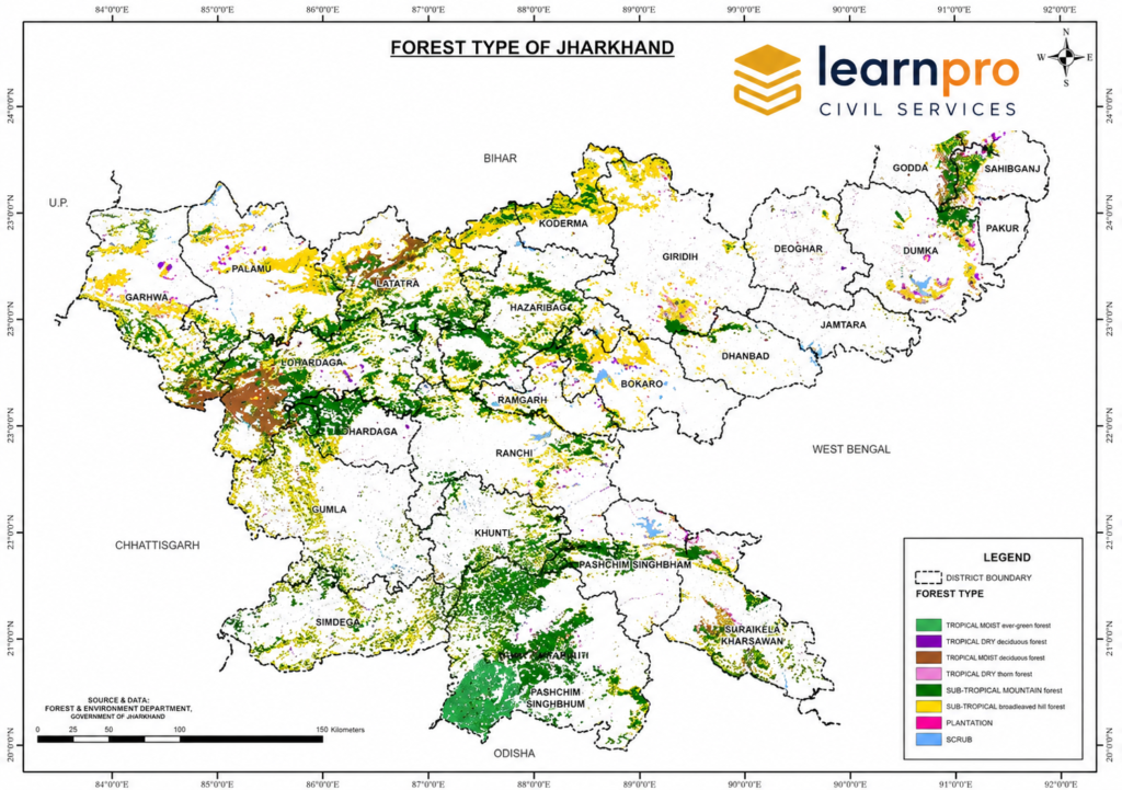
Jharkhand contains approximately 23,766 km² of forest cover, close to 30% of its geographical area. Forests are therefore not marginal features; they form one of the state’s principal landscape components.
Forest cover is concentrated particularly in:
- West Singhbhum;
- Latehar;
- Gumla;
- Simdega;
- Khunti;
- parts of Ranchi and adjoining western districts.
Rugged relief and relatively low agricultural accessibility have helped preserve extensive forest landscapes in these regions.
Forest-Cover Structure
Recent forest assessment places Jharkhand’s forest cover broadly as:
| Category | Approximate Area |
|---|---|
| Very Dense Forest | 2,635 km² |
| Moderately Dense Forest | 9,641 km² |
| Open Forest | 11,489 km² |
| Total | 23,766 km² |
Open forest therefore forms the largest canopy-density category.
Natural Vegetation
The dominant natural vegetation is tropical deciduous forest. Sal (Shorea robusta) is the characteristic tree across large areas and is accompanied by species such as mahua, kendu, palash, bamboo and kusum.
These forests perform several functions simultaneously:
- biodiversity conservation;
- soil and water protection;
- timber production;
- non-timber forest products;
- tribal and rural livelihoods.
Forests therefore possess both ecological and economic value.
Forests and Tribal Geography
The distribution of many Scheduled Tribe communities overlaps strongly with forested plateau regions. This is particularly evident in Kolhan, South Chotanagpur, Gumla-Simdega and other southern and western uplands.
Forests historically supplied food, fibres, fuel, grazing, medicines and marketable produce. Agricultural fields, common lands and forests therefore formed an interconnected livelihood system rather than separate spaces.
For the wider social geography, see Tribes of Jharkhand. Traditional land-use systems such as Shifting Cultivation in Jharkhand also illustrate how terrain, forests and agriculture interacted in parts of the state.
Wildlife Geography
Jharkhand’s major forest blocks support elephants, sloth bears, deer, wild boar, leopards and numerous bird and reptile species. Elephant distribution is especially significant because herds require large connected landscapes and frequently move between districts and neighbouring states.
Important protected landscapes include:
- Betla National Park
- Palamau Tiger Reserve
- Dalma Wildlife Sanctuary
Mining, highways, railway lines and expanding settlement have fragmented some wildlife landscapes, contributing to increased human-wildlife conflict.
Agriculture of Jharkhand
Jharkhand remains heavily dependent on monsoon-based agriculture. Rice is the dominant crop, particularly in low-lying fields capable of retaining rainfall.
Other important crops include:
- maize;
- pulses;
- oilseeds;
- millets;
- vegetables.
Agricultural potential varies dramatically over short distances because plateau relief produces differences in soil depth, slope and moisture.
Traditional Upland-Lowland Agricultural Pattern
A typical plateau village may contain several categories of agricultural land.
Uplands
These fields drain rapidly and generally possess thinner soils. They are more suited to maize, pulses, oilseeds and millets.
Middle Lands
These receive some runoff from upper slopes and can support more reliable seasonal cultivation.
Lowlands
These collect water and fine sediments, making them particularly suitable for paddy.
This land hierarchy shows how physical relief directly structures Jharkhand’s farming system.
Irrigation Constraint
Jharkhand’s numerous rivers do not automatically translate into extensive irrigation because many streams are highly seasonal and flow rapidly through dissected terrain.
Major difficulties include:
- steep gradients;
- rapid monsoon runoff;
- scattered fields;
- high evaporation during summer;
- uneven groundwater availability.
Consequently, tanks, ponds, check dams, lift irrigation, small reservoirs and watershed structures are particularly important.
Population Geography
According to Census 2011, Jharkhand had approximately 32.99 million people and a population density of about 414 persons per km². The state also has a substantial Scheduled Tribe population, accounting for approximately 26.21% of the total.
Population is very unevenly distributed. Dense concentrations occur around:
- Ranchi;
- Dhanbad;
- Bokaro;
- Jamshedpur;
- major mining corridors.
Lower densities occur in several rugged and heavily forested districts.
The detailed demographic structure is covered in Jharkhand Population Statistics.
Urban Geography
Jharkhand’s important cities developed for different geographical reasons.
| City | Principal Geographical Basis |
|---|---|
| Ranchi | Administrative and service centre on plateau |
| Jamshedpur | Iron and steel industry |
| Dhanbad | Coal-mining region |
| Bokaro | Steel and coal-industrial region |
| Deoghar | Religious and service economy |
| Hazaribagh | Regional administrative and educational centre |
Jharkhand therefore contains both administrative urbanisation and mineral-industrial urbanisation.
Industrial Geography
The state’s industrial geography is concentrated mainly in mineral-rich eastern and central belts. The combination of raw materials, water, railway connectivity and power encouraged heavy industries.
Jamshedpur
The location of Jamshedpur reflects proximity to:
- Singhbhum iron ore;
- coal-producing regions;
- river water;
- railway connections.
It developed into one of India’s earliest major planned industrial cities.
Dhanbad
Dhanbad is closely associated with the Jharia coalfield. Mining and coal-related activities created dense settlement, railway infrastructure and associated industries.
Bokaro
Bokaro developed into a major steel centre within the broader Damodar coal-industrial region.
Ramgarh
Ramgarh lies within an important coalfield and has developed extensive mining, power and industrial activities.
Transport Geography
Rail transport has a particularly close relationship with Jharkhand’s mineral economy. Railway lines were developed to connect coalfields, iron-ore mines, steel plants and markets.
Dense transport corridors therefore developed in:
- Dhanbad-Jharia;
- Bokaro;
- Ramgarh;
- Jamshedpur-Singhbhum.
In contrast, rugged forested areas historically remained less accessible because roads had to negotiate hills, valleys and dense vegetation.
Regional Geography of Jharkhand
Jharkhand can be grouped into five broad administrative-geographical regions, each with a distinctive physical and economic character.
| Region | Major Geographical Characteristics |
|---|---|
| North Chotanagpur | Hazaribagh uplands, Damodar basin, coalfields |
| South Chotanagpur | Ranchi Plateau, forests, tribal concentration |
| Kolhan | Singhbhum minerals, hills, dense forests |
| Palamu | Drier western plateau, North Koel basin |
| Santhal Pargana | Rajmahal Hills, eastern uplands and valleys |
The differences between these regions demonstrate why Jharkhand cannot be treated as a geographically homogeneous state.
Environment and Geographical Stress
Resource abundance has generated serious environmental pressures. Jharkhand simultaneously contains rich forests and minerals, creating direct competition between mining, industry, settlements, agriculture and ecological conservation.
Important environmental problems include:
- deforestation and fragmentation;
- mining-related land degradation;
- soil erosion;
- human-elephant conflict;
- river pollution;
- groundwater pressure;
- coal-mine fires;
- land subsidence;
- climate variability.
These issues are increasingly central to Jharkhand geography because human activity is now reshaping natural landscapes on a large scale.
Jharia Mine Fires and Subsidence
The Jharia coalfield is especially vulnerable to underground coal fires and land subsidence. Long-running fires can damage coal reserves, release pollutants and destabilise the surface above old mine workings.
The problem affects:
- settlements;
- roads and railway infrastructure;
- air quality;
- land stability.
Jharia therefore illustrates the close connection between economic geography and environmental geography.
Human-Elephant Conflict
Expansion of agriculture, settlements, mines and transport infrastructure into traditional elephant landscapes has increased encounters between people and elephants.
The issue is particularly significant in southern and eastern forest belts. Elephant conservation therefore depends not only on protected areas but also on maintaining landscape connectivity between forest blocks.
For detailed analysis, see Elephant Corridors and Human-Wildlife Conflict in Jharkhand.
Climate Change and Jharkhand
Climate variability presents a major challenge because Jharkhand depends heavily on monsoon agriculture, forests and surface-water systems. Changes in rainfall distribution, prolonged dry spells and higher temperatures can affect crop yields, groundwater recharge, forests and rural livelihoods simultaneously.
The geographical vulnerability is especially high where poverty, rainfed farming and environmental degradation overlap. Adaptation therefore requires watershed development, forest restoration, climate-resilient farming and improved water storage.
The policy dimension is discussed in Jharkhand State Action Plan on Climate Change.
Geography and the Jharkhand Economy
Jharkhand’s economy is one of India’s clearest examples of geography determining economic structure.
The relationship can be represented as:
Ancient geology
↓
Mineral deposits
↓
Mining
↓
Railways and power
↓
Heavy industry
↓
Industrial cities
At the same time:
Plateau + monsoon + red soils
↓
Rainfed agriculture
↓
Paddy-dominated valleys + less intensive uplands
And:
Forested rugged terrain
↓
High biodiversity + tribal concentration + forest livelihoods
These geographical chains explain many of Jharkhand’s present economic and developmental patterns.
Jharkhand Geography: Most Important Data
| Indicator | Important Figure/Fact |
|---|---|
| Area | 79,714 km² |
| Population – 2011 | ~32.99 million |
| Population density | 414/km² |
| Scheduled Tribe population share | 26.21% |
| Forest cover | ~23,766 km² |
| Forest cover share | about 30% |
| Highest point | Parasnath – ~1,365 m |
| Main plateau | Chotanagpur Plateau |
| Major volcanic region | Rajmahal Hills |
| Major coal basin | Damodar Gondwana Basin |
| Major metallic mineral belt | Singhbhum |
| Principal crop | Rice |
| Characteristic forest tree | Sal |
| Major industrial corridor | Damodar-Singhbhum belt |
Geographical Significance of Jharkhand
Jharkhand’s geographical importance arises from an unusual concentration of ancient landforms, mineral resources, forests and river systems. The Chotanagpur Plateau gives the state its basic relief, while geological diversity explains the coexistence of Gondwana coalfields, Singhbhum metallic minerals and Rajmahal volcanic rocks.
At the same time, geography creates major developmental constraints. Uneven relief limits irrigation and transport, seasonal rainfall creates drought vulnerability, mining causes environmental degradation, and fragmentation of forests affects wildlife and tribal livelihoods. Jharkhand therefore represents both the economic potential and environmental challenges of a mineral-rich tropical plateau region.
Students looking for connected state-specific material can continue through the JPSC Notes collection, where Jharkhand geography, environment, population, economy, history and tribal society are organised together.
Frequently Asked Questions (FAQs)
1. What is the geographical area of Jharkhand?
Jharkhand covers approximately 79,714 km².
2. Which geographical feature dominates Jharkhand?
The Chotanagpur Plateau dominates most of the state’s physical landscape.
3. Which states share boundaries with Jharkhand?
Jharkhand is bordered by Bihar, West Bengal, Odisha, Chhattisgarh and Uttar Pradesh.
4. Which is the highest point of Jharkhand?
Parasnath Hill or Shikharji, at about 1,365 metres, is the highest point of Jharkhand.
5. What are the major physiographic divisions of Jharkhand?
The important divisions include the Ranchi Plateau, Hazaribagh Plateau, Pat region, Damodar Valley, Palamu region, Singhbhum Plateau and Rajmahal Hills.
6. Why are the Rajmahal Hills unique?
The Rajmahal Hills are volcanic in origin, whereas much of Jharkhand consists of ancient crystalline plateau rocks.
7. Which are the major rivers of Jharkhand?
Major rivers include the Damodar, Barakar, Subarnarekha, North Koel, South Koel and Sankh.
8. Why does Jharkhand have many waterfalls?
Jharkhand’s rivers descend across different plateau levels and steep escarpments, producing numerous waterfalls.
9. Which river forms Hundru Falls?
Hundru Falls is formed by the Subarnarekha River.
10. Which river forms Dassam Falls?
Dassam Falls is associated with the Kanchi River.
11. What type of climate does Jharkhand have?
Jharkhand has a tropical monsoon climate modified by plateau elevation.
12. How much rainfall does Jharkhand generally receive?
Much of the state broadly receives around 1,100–1,400 mm of annual rainfall, although substantial regional and annual variation occurs.
13. Why does Jharkhand suffer from drought despite receiving monsoon rainfall?
Rainfall is concentrated in a few months, plateau slopes generate rapid runoff and irrigation remains uneven, producing seasonal water shortages.
14. Which are the major soils of Jharkhand?
The major soil groups are red and yellow soils, lateritic soils and deeper valley/alluvial soils.
15. What percentage of Jharkhand is covered by forests?
Recent assessments place forest cover at close to 30% of the state’s geographical area.
16. Which tree dominates Jharkhand’s forests?
Sal is the characteristic and most important tree of many Jharkhand forests.
17. Which districts contain major forest landscapes?
Important forest belts occur particularly in West Singhbhum, Latehar, Gumla, Simdega, Khunti and adjoining areas.
18. What percentage of Jharkhand’s population belongs to Scheduled Tribes?
According to Census 2011, Scheduled Tribes account for approximately 26.21% of Jharkhand’s population.
19. Which mineral is most closely associated with the Damodar Valley?
Coal is the dominant mineral resource of the Damodar Gondwana basin.
20. Which are the major coalfields of Jharkhand?
The major coalfields include Jharia, Bokaro, Ramgarh, North Karanpura and South Karanpura.
21. Where is iron ore concentrated in Jharkhand?
Iron ore is concentrated primarily in the Singhbhum Iron Ore Belt, particularly in West Singhbhum.
22. Where is bauxite found?
Important bauxite deposits occur in the Lohardaga and western high plateau region.
23. Which area is historically famous for mica?
The Koderma-Giridih belt is historically associated with major mica deposits.
24. Why did Jamshedpur develop as an industrial city?
Its location provides access to iron ore, coal, water and transportation, creating favourable conditions for iron and steel production.
25. Why is Dhanbad important?
Dhanbad developed as a major mining centre because of its association with the Jharia coalfield.
26. What is Jharkhand’s principal agricultural crop?
Rice or paddy is the principal crop, particularly in moisture-retaining lowlands.
27. Why is irrigation difficult in Jharkhand?
Uneven plateau terrain, seasonal rivers, rapid runoff and dispersed agricultural fields complicate large-scale irrigation.
28. Why are elephants geographically important in Jharkhand?
Jharkhand forms part of an important eastern Indian elephant landscape, especially across the Singhbhum-Dalma forest belt.
29. What are the major geographical environmental problems of Jharkhand?
Major problems include mining degradation, deforestation, soil erosion, human-elephant conflict, drought, mine fires, subsidence and water pollution.
30. What is the defining geographical character of Jharkhand?
Jharkhand is fundamentally an ancient, forested and mineral-rich plateau state in which geology and relief strongly influence rivers, agriculture, forests, settlement and industrial development.





