
Physiographic Divisions of Jharkhand: Jharkhand is predominantly a plateau state, but its surface is far from uniform. The state contains several distinct physiographic units created by differences in geological structure, elevation, erosion, faulting and drainage. The Chotanagpur Plateau forms the broad physical framework, but within it lie high plateaus, lower plateaus, structural basins, residual hills, escarpments and river valleys.
The physiographic divisions of Jharkhand are important because they explain the distribution of rivers, waterfalls, soils, forests, agriculture, minerals and settlements. The high western plateaus differ sharply from the coal-bearing Damodar basin, while the volcanic Rajmahal Hills are geologically different from the ancient crystalline plateaus of Ranchi and Singhbhum. A proper understanding of Jharkhand geography therefore requires studying these divisions separately.
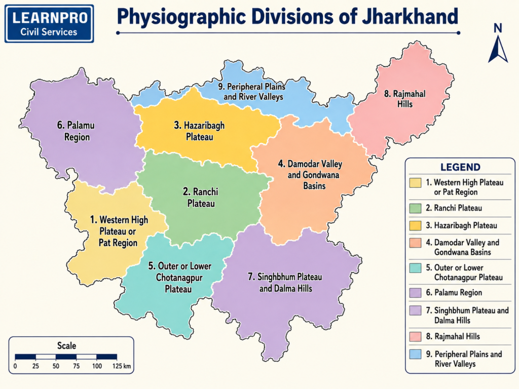
For a wider overview of the state’s physical setting, see Jharkhand Geography Notes.
Physiographic Framework of Jharkhand
Jharkhand occupies a large part of the Chotanagpur Plateau, which belongs to the ancient Peninsular Shield of India. The plateau has been subjected to prolonged denudation, tectonic movements and river erosion, creating a stepped landscape with surfaces at different elevations.
The major physiographic divisions can broadly be grouped as:
- Western High Plateau or Pat Region
- Ranchi Plateau
- Hazaribagh Plateau
- Damodar Valley and Gondwana Basins
- Outer or Lower Chotanagpur Plateau
- Palamu Region
- Singhbhum Plateau and Dalma Hills
- Rajmahal Hills
- Peripheral Plains and River Valleys
These divisions are not separated everywhere by sharp boundaries. In many areas one plateau surface gradually merges into another through escarpments, valleys or dissected uplands.

Physiographic Divisions at a Glance
| Physiographic Division | General Elevation/Character | Important Areas | Major Geographical Feature |
|---|---|---|---|
| Pat Region | Highest plateau surfaces, often around 900–1,100 m | Latehar, Gumla, Lohardaga | Flat-topped highlands |
| Ranchi Plateau | About 600–700 m in broad plateau areas | Ranchi, Khunti and surroundings | Waterfalls and rolling uplands |
| Hazaribagh Plateau | Elevated northern plateau | Hazaribagh and adjoining areas | Dissected uplands |
| Damodar Valley | Lower structural basin | Dhanbad, Bokaro, Ramgarh | Gondwana coalfields |
| Palamu Region | Dissected plateau and basin | Palamu, Latehar, Garhwa | North Koel drainage |
| Singhbhum Plateau | Rugged mineral-rich uplands | West and East Singhbhum | Iron-copper mineral belt |
| Dalma Hills | Linear forested hill system | East Singhbhum | Wildlife and hill relief |
| Rajmahal Hills | Volcanic hill region | Sahibganj, adjoining Santhal Pargana | Rajmahal Traps |
| Peripheral Lowlands | Lower valleys and plains | Northern and eastern margins | Agriculture and dense settlement |
1. Western High Plateau or Pat Region
The Pat Region forms the highest extensive plateau surface of western Jharkhand. The word Pat is locally used for elevated, relatively flat-topped uplands with steep margins. These surfaces occur particularly in parts of Latehar, Gumla and Lohardaga.
Many Pat surfaces reach approximately 900–1,100 metres above mean sea level, although elevation differs from one locality to another. They represent old erosional surfaces that have survived because resistant rock formations protected them from complete denudation.
The main characteristics of the Pat region are:
- high elevation;
- broad and comparatively flat summits;
- steep escarpments;
- deep valleys around the margins;
- lateritic weathering;
- considerable forest cover;
- bauxite deposits on selected surfaces.
The high elevation also modifies the local climate, producing cooler conditions than in the lower Damodar and Palamu valleys.
Important Pats
Important highland areas associated with the western Pat system include:
- Netarhat;
- Jamira;
- Khamar;
- Rud;
- other high tablelands of western Jharkhand.
The exact local nomenclature varies, but together these elevated surfaces form the highest physiographic tier of the state.
Netarhat Plateau
The Netarhat Plateau is the best-known part of the western high plateau system. Much of its upper surface lies at roughly 1,000 metres or more, making it substantially higher than the Ranchi Plateau.
Its relief consists of a relatively level upper surface surrounded by steep slopes and deeply dissected valleys. Forests remain extensive because high elevation, rugged terrain and difficult accessibility historically restricted intensive agricultural expansion.
Netarhat is therefore important not simply as a scenic hill station but as a representative example of Jharkhand’s highest plateau level.
2. Ranchi Plateau
The Ranchi Plateau forms the central physiographic core of Jharkhand and is one of the most distinctive subdivisions of the Chotanagpur Plateau. Much of the plateau lies at an average elevation of roughly 600–700 metres, although local heights vary.
The surface is broadly undulating rather than completely flat. Numerous streams have dissected it into low ridges, valleys and agricultural depressions. Rivers flowing from the plateau frequently encounter abrupt breaks in slope along its margins, producing several of Jharkhand’s famous waterfalls.
Major geographical characteristics include:
- broad plateau surface;
- red and yellow soils;
- numerous streams;
- shallow valleys;
- waterfalls along escarpments;
- extensive agricultural depressions;
- urban concentration around Ranchi.
Waterfalls and the Ranchi Plateau
The Ranchi Plateau is particularly well known for waterfalls because of sudden differences in elevation between the plateau surface and surrounding lower regions.
Important examples include:
- Hundru Falls on the Subarnarekha;
- Dassam Falls on the Kanchi;
- Jonha Falls in the Ranchi plateau region.
The concentration of waterfalls is therefore a direct result of the plateau’s geomorphology.
Ranchi Plateau as a Water Divide
The elevated Ranchi Plateau functions as an important water-divide region. Rivers originating in or near the plateau flow towards different drainage systems.
Some streams flow eastward towards the Subarnarekha, while others contribute to the South Koel and related systems. This demonstrates how elevation controls drainage direction.
For the detailed river network, see Drainage System of Jharkhand.
3. Hazaribagh Plateau
The Hazaribagh Plateau lies north of the Ranchi Plateau and forms another major elevated physiographic surface. It is separated from the Ranchi Plateau by the Damodar Valley, creating one of the clearest relief contrasts in Jharkhand.
The plateau generally has a lower and more dissected appearance than the western Pats. Rolling uplands, forested ridges, valleys and isolated hills dominate the landscape.
Its major physical characteristics include:
- elevated plateau terrain;
- deeply dissected drainage;
- forested uplands;
- isolated residual hills;
- proximity to Gondwana basins.
The plateau forms an important physical transition between the Damodar basin and the lower northern margins of Jharkhand.
Hazaribagh Plateau and Drainage
Streams from the Hazaribagh uplands flow towards the Damodar-Barakar system and adjoining drainage basins. Valleys created by these streams provide agricultural land and routes through an otherwise uneven landscape.
The proximity of the Hazaribagh Plateau to coal-bearing basins has also strongly influenced settlement and modern transport networks in North Chotanagpur.
4. Damodar Valley
The Damodar Valley forms one of the most distinctive structural depressions within Jharkhand. It lies between major plateau surfaces and contains extensive Gondwana sedimentary formations.
Unlike the surrounding ancient crystalline uplands, the Damodar basin contains comparatively younger sedimentary rocks. These formations contain thick coal seams and have made the valley one of India’s most important mining-industrial regions.
The principal coalfields include:
- Jharia
- Bokaro
- Ramgarh
- North Karanpura
- South Karanpura
This makes the Damodar Valley both a major physiographic division and an economic region of national importance.
Structural Character of the Damodar Valley
The valley developed along faulted and depressed sections of the ancient plateau. Sediments accumulated within these troughs over long geological periods.
The physiographic contrast is therefore clear:
Crystalline Plateau Uplands → Faulted Depression → Gondwana Sediments → Coalfields
The broad lower relief of the basin subsequently encouraged railways, settlements, mining and industrial development.
Damodar Valley and Industrial Geography
Dhanbad, Bokaro and Ramgarh developed within or close to this structural basin. Coal availability attracted mining, power generation, steel production and associated urban development.
The Damodar region is therefore an excellent example of how a physiographic unit became an industrial region because of its geological structure.
5. Outer or Lower Chotanagpur Plateau
Beyond the main Ranchi and Hazaribagh surfaces lie lower plateau regions that form the outer margins of the Chotanagpur system. These are generally more heavily dissected and occur at lower elevations than the central plateau surfaces.
They include parts of:
- eastern Jharkhand;
- northern plateau margins;
- lower sections surrounding the major high plateaus.
The terrain contains rolling uplands, small hills and broad valleys rather than extensive high tablelands.
These lower plateaus often provide better conditions for:
- agriculture;
- road construction;
- settlement;
- market development.
Their lower elevation also marks the gradual transition from the Chotanagpur Plateau towards the plains of Bihar and West Bengal.
6. Palamu Plateau and Basin
The Palamu region occupies western and north-western Jharkhand. Its terrain consists of dissected plateau surfaces, forested hills, broad valleys and basin-like depressions.
The region is drained primarily by the North Koel River and its tributaries. River valleys provide relatively fertile agricultural land, while surrounding uplands remain more forested and less densely populated.
The physiography of Palamu is characterised by:
- broken plateau terrain;
- hills and ridges;
- dry valleys;
- forested slopes;
- North Koel basin.
Palamu also experiences comparatively high summer temperatures and recurrent drought conditions, partly because of its interior location and seasonal rainfall pattern.
North Koel Valley
The North Koel valley forms the principal low-lying corridor through Palamu. It is important for settlement, agriculture and transport because the surrounding terrain is more rugged.
The valley ultimately connects Jharkhand with the Son-Ganga drainage system.
This makes Palamu physiographically distinct from the Damodar and Subarnarekha basins farther east.
7. Singhbhum Plateau
The Singhbhum Plateau occupies much of southern Jharkhand. It consists of ancient geological formations, rugged hills, forested valleys and mineral-bearing belts.
The relief is generally more broken than the Ranchi Plateau. Resistant rocks create ridges and hills, while streams have carved narrow valleys through weaker formations.
The region is especially important because it contains major deposits of:
- iron ore;
- copper;
- uranium;
- manganese and associated minerals.
Its geology has therefore shaped both the physical landscape and the modern industrial geography of Jharkhand.
Singhbhum Iron Ore Highlands
The western Singhbhum region contains important iron-bearing hills and ridges. Mining areas around the wider Noamundi-Gua belt developed because mineralised geological formations are exposed close to the surface.
The landscape today combines:
- forested hills;
- mining areas;
- railway corridors;
- tribal settlements.
This juxtaposition of forests and mineral extraction makes Singhbhum one of Jharkhand’s most complex geographical regions.
8. Dalma Hills
The Dalma Hills form a distinctive hill range near Jamshedpur in East Singhbhum. They rise above the adjoining lower plateau and form a conspicuous physiographic feature.
The hills are:
- rugged;
- forested;
- ecologically important;
- associated with elephant movement.
Their proximity to the heavily urbanised Jamshedpur-Adityapur region creates a sharp contrast between natural upland landscapes and industrial development.
The Dalma landscape is also important in understanding the relationship between relief and wildlife corridors.
9. Rajmahal Hills
The Rajmahal Hills lie mainly in Sahibganj and adjoining parts of north-eastern Jharkhand. They are physiographically and geologically distinct from the Chotanagpur crystalline plateaus because they were created largely by ancient volcanic activity.
The hills are composed mainly of basaltic lava flows collectively known as the Rajmahal Traps.
Important characteristics include:
- volcanic origin;
- basaltic rocks;
- steep slopes;
- narrow valleys;
- forested hill tracts.
The Rajmahal Hills form an isolated upland mass close to the Ganga valley and therefore present a very different landscape from Ranchi or Singhbhum.
Rajmahal Hills and the Ganga Plain
The northern and north-eastern margins of the Rajmahal Hills descend towards the Ganga valley. This creates a sharp local transition from rocky hill terrain to lower alluvial areas.
The contrast has influenced:
- settlement location;
- agriculture;
- transport routes;
- river communication.
The Sahibganj region is therefore one of the few places where Jharkhand’s plateau and hill geography directly approaches the Ganga.
10. Parasnath Hill and Isolated Residual Uplands
Jharkhand also contains numerous isolated residual hills that stand above surrounding plateau surfaces. The most important is Parasnath Hill or Shikharji in Giridih district.
Parasnath rises to about 1,365 metres above mean sea level, making it the highest point of Jharkhand. Its elevation is substantially greater than the surrounding plateau, giving it a prominent physical presence.
The hill represents an important residual highland and is also a major Jain pilgrimage centre.
Residual Hills and Inselbergs
Long-term erosion does not remove all rocks at the same rate. Harder and more resistant formations remain standing after surrounding softer rocks have been lowered.
Such residual features contribute to Jharkhand’s characteristic landscape of:
- isolated hills;
- rocky ridges;
- rounded uplands;
- steep local relief.
These forms are especially common across the old crystalline plateau.
11. Northern Peripheral Plains
The northern margin of Jharkhand gradually descends towards the Middle Ganga Plain of Bihar. This region generally has lower relief than the central plateau and contains broader valleys and more extensive agricultural surfaces.
The transition is particularly noticeable in parts of:
- Sahibganj;
- Godda;
- Deoghar;
- Giridih;
- Koderma;
- north-western districts.
However, the terrain remains mixed, with hills and plateau remnants continuing into many northern districts.
Agricultural Importance of Lower Relief
Lower and gentler terrain generally provides:
- deeper soils;
- better moisture accumulation;
- easier irrigation;
- better road access.
Consequently, such valleys and peripheral lowlands often support denser settlements than rugged plateau interiors.
This does not mean that all northern districts are plains; rather, they represent a transition between plateau and plain environments.
12. Eastern Peripheral Region
Eastern Jharkhand gradually descends towards West Bengal, particularly along major river valleys such as the Damodar, Ajay and Subarnarekha.
These valleys act as natural corridors connecting the plateau with the Bengal plains.
As elevation decreases:
- valleys broaden;
- transport becomes easier;
- settlement density generally increases;
- agriculture becomes more intensive in suitable locations.
This eastward opening played an important role in the later development of mining and industrial transport.
Physiography and Drainage
The physiographic divisions directly control Jharkhand’s drainage pattern.
Ranchi Plateau
Acts as an important source area for the:
- Subarnarekha;
- South Koel and associated streams.
Hazaribagh and Damodar Region
Drains mainly through:
- Damodar;
- Barakar;
- associated tributaries.
Palamu Region
Drains mainly through:
- North Koel.
South-Western Highlands
Drain through:
- South Koel;
- Sankh.
North-Eastern Region
Contains tributaries connected with:
- Ajay;
- Mayurakshi;
- Ganga-side drainage.
For the detailed river network, see Drainage System of Jharkhand.
Physiography and Waterfalls
Jharkhand’s major waterfalls occur where rivers descend from higher plateau levels to lower surfaces.
The relationship can be represented as:
Elevated Plateau → River Incision → Escarpment/Break in Slope → Waterfall
The Ranchi Plateau is especially important because of its pronounced escarpments.
| Waterfall | Physiographic Association |
|---|---|
| Hundru | Ranchi Plateau – Subarnarekha descent |
| Dassam | Ranchi Plateau – Kanchi River |
| Jonha | Ranchi Plateau margin |
| Lodh | Western high plateau region |
| Hirni | Singhbhum/western plateau landscape |
Thus, waterfalls provide visible evidence of differences in plateau elevation.
Physiography and Soil Distribution
Relief also controls soil depth and soil type.
High Plateau Surfaces
Often contain:
- lateritic soils;
- shallow soils;
- weathered surfaces.
Rolling Crystalline Plateaus
Dominated mainly by:
- red and yellow soils.
Valley Bottoms
Contain:
- deeper colluvial and alluvial material;
- better moisture retention;
- more productive agricultural land.
Soil fertility in Jharkhand therefore varies considerably even within a small geographical area because of differences in slope and elevation.
Physiography and Agriculture
Traditional agriculture closely follows the local relief.
A typical plateau landscape can be divided into:
Upper slope → Middle slope → Valley bottom
Upper slopes lose water rapidly and generally have thinner soils. Valley bottoms collect runoff and sediment and therefore support more intensive paddy cultivation.
This creates a characteristic agricultural pattern:
| Relief Position | Agricultural Character |
|---|---|
| Upland | Maize, millets, pulses, oilseeds |
| Middle land | Mixed seasonal crops |
| Lowland | Paddy and moisture-demanding crops |
The relationship between relief and agriculture is one of the most important characteristics of Jharkhand’s rural geography.
Physiography and Forest Distribution
Forests are more extensive in rugged physiographic regions where agriculture and dense settlement are difficult.
Important examples include:
- West Singhbhum hills;
- Latehar highlands;
- Gumla-Simdega plateau;
- Dalma Hills;
- parts of the Rajmahal Hills.
Gentler valleys and lower plateaus have generally experienced greater agricultural clearance.
For the wider relationship between forest landscapes and indigenous communities, see Tribes of Jharkhand.
Physiography and Mineral Distribution
Mineral distribution closely follows geological and physiographic divisions.
| Physiographic/Geological Region | Important Minerals |
|---|---|
| Damodar Valley | Coal |
| Singhbhum Plateau | Iron ore, copper, uranium |
| Western Pats | Bauxite |
| Koderma-Giridih region | Mica |
| Rajmahal region | Basalt and related building materials |
This pattern explains why mining towns are concentrated in specific physiographic regions rather than evenly distributed across Jharkhand.
Physiography and Settlement Pattern
Human settlement tends to be denser in relatively flat and economically productive areas.
High population concentrations developed in:
- agricultural valleys;
- coal basins;
- mineral-industrial centres;
- major transport corridors.
Lower settlement densities are common in:
- steep forested hills;
- high Pats;
- rugged interior plateaus.
Thus, physical relief has influenced both traditional rural settlement and modern urbanisation.
Physiography and Transport
Plateau terrain creates significant transport challenges. Roads and railways tend to follow valleys, lower passes and gentler surfaces rather than crossing steep escarpments directly.
The Damodar Valley became a major transport corridor because its relatively lower relief coincided with extensive coal resources. Similarly, railway lines in Singhbhum developed to connect mineral belts with Jamshedpur and other industrial centres.
The contrast is clear:
Valley/basin → easier transport
High dissected plateau → higher construction difficulty
Physiography and Climate
Elevation modifies temperature across Jharkhand. Higher areas such as Netarhat and Ranchi experience comparatively moderate temperatures, while lower basins such as Palamu can become much hotter during summer.
Relief also affects:
- rainfall distribution;
- local winds;
- humidity;
- runoff.
Therefore, climatic differences within Jharkhand cannot be explained solely by latitude.
Physiography and Drought
The high plateau structure produces rapid monsoon runoff. Rainwater often moves quickly from uplands into streams rather than remaining available in the soil.
Areas with:
- shallow soils;
- steep slopes;
- limited reservoirs;
- low irrigation coverage
can experience water scarcity soon after the monsoon ends.
The Palamu region is particularly vulnerable because comparatively lower rainfall combines with high temperatures and uneven water storage.
Physiographic Profile by Region
| Region | Relief | Drainage | Major Resource/Feature |
|---|---|---|---|
| Western Pats | Highest flat-topped uplands | Headwater streams | Bauxite, forests |
| Ranchi Plateau | Broad central plateau | Subarnarekha, South Koel | Waterfalls, agriculture |
| Hazaribagh Plateau | Rolling upland | Damodar-Barakar tributaries | Forests, mineral proximity |
| Damodar Basin | Structural depression | Damodar-Barakar | Coal and industry |
| Palamu | Dissected plateau/basin | North Koel | Forests, drought-prone agriculture |
| Singhbhum | Rugged mineral plateau | Subarnarekha-related and southern streams | Iron, copper, uranium |
| Dalma | Hill range | Short hill streams | Forest and wildlife |
| Rajmahal | Volcanic hills | Ganga-side/eastern drainage | Basaltic terrain |
| Northern Margin | Lower plateau/plain transition | Ganga tributary systems | Agriculture and settlement |
Altitudinal Pattern of Jharkhand
Jharkhand’s relief may be understood broadly through three levels.
High Plateau Level
Approximately 900 metres and above in major western Pat areas and isolated highlands.
Examples:
- Netarhat highlands;
- western Pats;
- Parasnath as an isolated summit.
Middle Plateau Level
Broadly around 500–700 metres in important central plateau regions.
Examples:
- Ranchi Plateau;
- parts of Hazaribagh uplands.
Lower Plateau and Basin Level
Lower surfaces occur in:
- Damodar Valley;
- northern margins;
- eastern river valleys.
This altitudinal arrangement helps explain differences in temperature, drainage and agriculture.
Physiography and Economic Development
Jharkhand’s modern economy has developed along the lines created by its physical geography.
The relationship is particularly clear:
Damodar Basin → Coal → Mining + Power + Steel
Singhbhum Plateau → Iron Ore → Mining + Jamshedpur Industrial Belt
Western Pats → Bauxite → Mining
Valleys → Agriculture + Settlement
Forested Hills → Forest Livelihoods + Biodiversity
Thus, physiographic divisions are not merely descriptive physical regions; they have determined the state’s economic geography.
Physiographic Divisions and Environmental Problems
Different physical regions face different environmental stresses.
Damodar Valley
- mine fires;
- subsidence;
- industrial pollution;
- river pollution.
Singhbhum Plateau
- mining-related deforestation;
- habitat fragmentation;
- soil disturbance.
Western High Plateaus
- erosion;
- bauxite-mining impacts;
- forest degradation.
Palamu Region
- drought;
- forest degradation;
- water scarcity.
Dalma-Singhbhum Landscape
- habitat fragmentation;
- human-elephant conflict.
The environmental problems of Jharkhand are therefore strongly regional.
Why Physiographic Divisions Matter
Understanding physiographic divisions helps explain almost every major geographical pattern in Jharkhand.
They determine:
- where rivers originate;
- where waterfalls form;
- where coal and metallic minerals occur;
- where forests remain extensive;
- where agriculture is most productive;
- where cities and industries developed;
- where transport is easier or more difficult;
- where drought and erosion are more severe.
Physiography therefore provides the basic framework for studying the entire geography of Jharkhand.
Physiographic Divisions: Final Summary
Jharkhand can broadly be understood as a series of stepped plateau surfaces separated by valleys, structural basins and hill systems. The high western Pats form the upper level, the Ranchi and Hazaribagh plateaus form important intermediate surfaces, and the Damodar basin and peripheral valleys occupy lower levels.
Southern Jharkhand is distinguished by the rugged and mineral-rich Singhbhum Plateau, while north-eastern Jharkhand contains the geologically unique Rajmahal Hills. The Palamu region forms a separate western dissected plateau-basin system dominated by the North Koel drainage.
The physiographic structure can therefore be simplified as:
Western High Pats
↓
Ranchi and Hazaribagh Plateau Surfaces
↓
Damodar and Other Structural Valleys
↓
Lower Peripheral Plateaus and Plains
Alongside these occur the distinct Singhbhum mineral highlands, Dalma Hills and Rajmahal volcanic hills.
Frequently Asked Questions (FAQs)
1. What is the dominant physiographic feature of Jharkhand?
The Chotanagpur Plateau is the dominant physiographic feature of Jharkhand.
2. Is the Chotanagpur Plateau a single flat surface?
No. It consists of several plateau levels, basins, hills, valleys and escarpments.
3. What are the major physiographic divisions of Jharkhand?
The major divisions include the Pat region, Ranchi Plateau, Hazaribagh Plateau, Damodar Valley, Palamu region, Singhbhum Plateau, Dalma Hills and Rajmahal Hills.
4. Which is the highest extensive plateau region of Jharkhand?
The western Pat region, including Netarhat and adjoining highlands, forms the highest extensive plateau surface.
5. What is a Pat?
A Pat is a locally used term for a high, relatively flat-topped plateau surface with steep margins.
6. Where are the Pats mainly found?
They occur mainly in Latehar, Gumla, Lohardaga and adjoining western highlands.
7. What is the approximate elevation of many western Pats?
Many major Pat surfaces lie roughly around 900–1,100 metres, although elevations vary locally.
8. What is the approximate elevation of the Ranchi Plateau?
Much of the Ranchi Plateau lies roughly around 600–700 metres above mean sea level.
9. Why is the Ranchi Plateau famous for waterfalls?
Rivers descend over sharp breaks in slope along the plateau margins, creating waterfalls.
10. Which famous waterfalls are associated with the Ranchi Plateau?
Hundru, Dassam and Jonha are important examples.
11. Where is the Hazaribagh Plateau located?
It lies north of the Ranchi Plateau in the North Chotanagpur region.
12. What separates the Ranchi and Hazaribagh plateau regions?
The Damodar Valley and associated lower structural terrain form an important division between them.
13. Why is the Damodar Valley physiographically important?
It is a structural depression containing Gondwana sedimentary formations and major coalfields.
14. Which coalfields occur in the Damodar and associated Gondwana basins?
Important coalfields include Jharia, Bokaro, Ramgarh, North Karanpura and South Karanpura.
15. What is the principal physiographic feature of Palamu?
Palamu consists mainly of dissected plateau terrain, forested hills and the North Koel basin.
16. Which river dominates the Palamu region?
The North Koel River.
17. Why is the Singhbhum Plateau important?
It contains ancient rock formations and major deposits of iron ore, copper, uranium and other metallic minerals.
18. What are the Dalma Hills?
The Dalma Hills are a forested hill range near Jamshedpur and an important wildlife landscape.
19. What is unique about the Rajmahal Hills?
They are mainly volcanic in origin and consist largely of basaltic lava formations.
20. What are the Rajmahal Traps?
The Rajmahal Traps are ancient basaltic lava formations associated with the Rajmahal Hills.
21. Which is the highest point of Jharkhand?
Parasnath Hill or Shikharji, at about 1,365 metres, is the highest point of Jharkhand.
22. Why are valleys agriculturally important?
Valleys accumulate deeper soils and moisture, making them more suitable for intensive agriculture, especially paddy.
23. Why are forests concentrated in rugged plateau areas?
Steep and inaccessible terrain historically restricted agricultural clearance and dense settlement.
24. How does physiography influence mineral distribution?
Different geological and physiographic units contain different mineral formations—for example, coal in Gondwana basins, iron and copper in Singhbhum, and bauxite on western lateritic plateaus.
25. How does relief affect transport in Jharkhand?
Railways and roads tend to follow valleys, basins and gentler plateau surfaces, while steep hills and escarpments make construction more difficult.
26. Why is Palamu more drought-prone?
The region combines comparatively variable rainfall, high summer temperatures, rapid runoff and limited irrigation.
27. How are waterfalls related to physiographic divisions?
They commonly occur where rivers move from higher plateau surfaces to lower physiographic levels.
28. How does physiography influence settlement?
Dense settlement occurs more often in valleys, industrial basins and relatively level areas, while high forested plateaus generally have lower settlement density.
29. Which physiographic division is most important for Jharkhand’s coal industry?
The Damodar Valley and associated Gondwana basins.
30. What is the central idea behind Jharkhand’s physiographic divisions?
Jharkhand is best understood as a multi-level, dissected plateau landscape consisting of high Pats, intermediate plateaus, structural basins, mineral highlands, volcanic hills and peripheral valleys.





