
Siwalik Hills, also written Shivalik or Sivalik, form the youngest and southernmost belt of the Himalayan mountain system. Built mainly from river-borne sediments shed by the rising Himalaya, they connect geology, groundwater recharge, forests, wildlife movement and disaster risk. For UPSC, the key is to understand the Siwalik–Bhabar–Terai system as one physical and ecological unit.
UPSC relevance: GS Paper I—Himalayan physiography and drainage; GS Paper III—biodiversity, groundwater, erosion and disaster management; Prelims—Bhabar and Terai. Focus keyword: Siwalik Hills.
Where are the Siwalik Hills located?
The Siwaliks run broadly parallel to the higher Himalayan ranges along the mountain front, from the north-west towards the eastern Himalaya. In India they occur across parts of Jammu, Himachal Pradesh, Punjab, Haryana, Uttarakhand, Uttar Pradesh and the eastern Himalayan foothills. Local names and continuity vary, and longitudinal valleys called duns occur between the Siwalik and Lesser Himalayan ranges; Dehra Dun is the best-known example.
How were the Siwalik Hills formed?
The Himalaya rose as the Indian plate converged with Eurasia. Rivers eroded the rising ranges and deposited huge volumes of sand, gravel, silt and clay in the foreland basin to the south. Continued compression folded and uplifted these sediments to create the Siwalik belt.
The rocks are largely sandstone, mudstone, siltstone and conglomerate. Because many deposits are young, weakly consolidated and cut by active structures near the Himalayan front, slopes erode easily. This helps explain gullies, high sediment loads, landslides and rapid channel change during intense monsoon rain.
| Feature | Siwalik significance |
|---|---|
| Tectonic position | Outermost Himalayan foothill belt near the active mountain front |
| Dominant material | River-laid sandstone, mudstone and conglomerate |
| Landscape behaviour | High erodibility, flashy streams and heavy sediment movement |
| Palaeontology | Rich vertebrate fossil record used to study past environments and evolution |
| Human importance | Forests, groundwater recharge, agriculture, transport corridors and settlements |
How do Bhabar and Terai hydrology work?
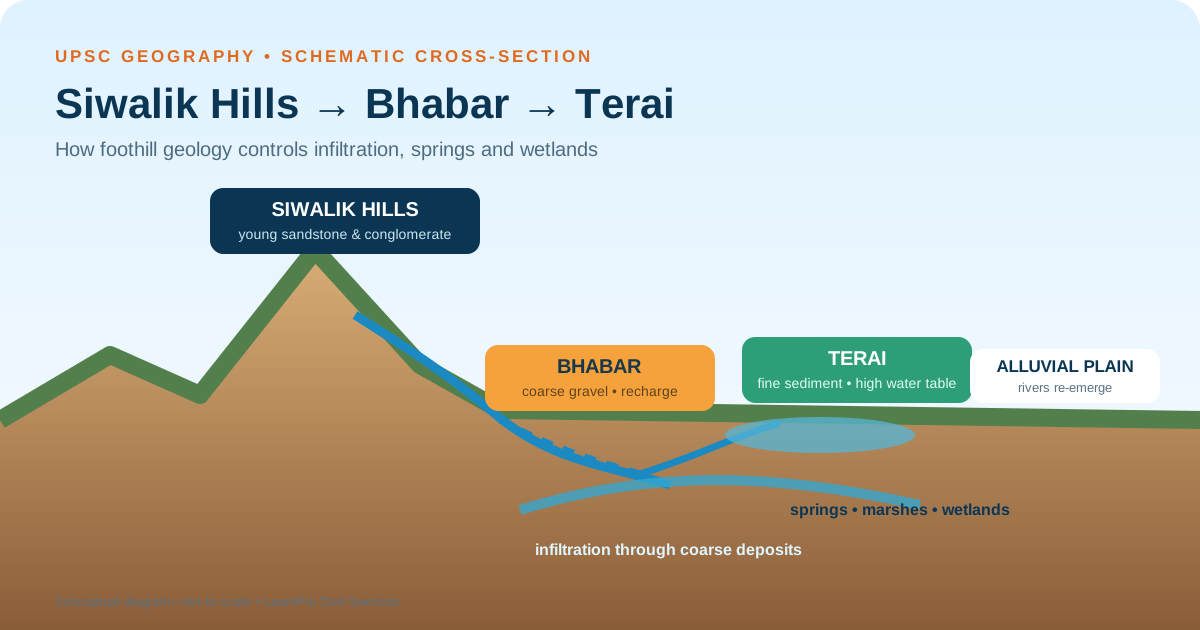
Rivers descending from the Siwalik Hills lose gradient at the mountain front and deposit coarse boulders, pebbles and gravel. This forms the porous Bhabar belt. Surface flow often sinks into the coarse material, recharging aquifers.
Farther south, finer alluvium and a shallower water table characterise the Terai. Water that infiltrated in the Bhabar may reappear through springs, seepage and perennial channels. The result is a wetter landscape that historically supported marshes, tall grasslands and dense forests.
- Bhabar: coarse, highly permeable deposits; many streams lose surface flow; important recharge zone.
- Terai: finer sediments, high water table and re-emergent flow; prone to waterlogging and flooding in places.
- Policy link: quarrying, road cutting, channel modification and unplanned construction in recharge zones can alter both groundwater and flood behaviour.
Why are the Siwaliks important for biodiversity?
The foothills contain sal forests, riverine forests, grasslands and seasonal streams. They form part of the Terai Arc Landscape, where protected areas and forest corridors support movement of elephants, tigers and other wildlife. Connectivity is crucial because a protected area cannot sustain wide-ranging species if roads, railways, settlements and linear infrastructure isolate it.
Corridors also allow seasonal movement and genetic exchange. Their value is ecological, not simply visual forest cover. A narrow plantation cannot automatically replace a natural riverine or sal-forest corridor.
Major threats to the Siwalik landscape
- Deforestation and repeated fire reduce root binding, infiltration and habitat quality.
- Mining and quarrying of boulders, sand and gravel can destabilise slopes and channels when poorly regulated.
- Roads, railways and power lines fragment corridors and increase collision risk.
- Encroachment and urban growth occupy floodplains, duns and recharge areas.
- Intense rainfall acts on fragile material, increasing erosion, debris flow and sedimentation.
- Invasive species and grazing pressure can change grassland and forest regeneration.
Development risk in the Himalaya is examined further in LearnPro’s analysis of Himalayan infrastructure pressure.
Which laws and institutions apply?
There is no single “Siwalik law”. Governance is distributed across several frameworks:
- the Environment (Protection) Act, 1986 and environmental-impact rules;
- the Van (Sanrakshan Evam Samvardhan) Adhiniyam, 1980 for specified forest-land diversion;
- the Wild Life (Protection) Act, 1972 for protected areas and species;
- State mining, groundwater, land-use and disaster-management rules;
- pollution-control boards, forest departments, groundwater authorities and local bodies; and
- court and tribunal directions in specific projects or landscapes.
The practical weakness is fragmented decision-making. A road may be assessed as a transport project, a quarry as a mining lease and a township as land development, while their combined effect on a watershed and wildlife corridor remains unmeasured.
What should an integrated management plan include?
- Map ecological and hydrological sensitivity: identify recharge zones, active channels, unstable slopes and wildlife corridors before project approval.
- Use cumulative assessment: evaluate the combined load of roads, mines, tourism and settlements within a catchment.
- Protect natural drainage: avoid narrowing channels and building on fan surfaces or flood pathways without robust hazard analysis.
- Restore with native vegetation: stabilise slopes and riverbanks using site-appropriate species rather than cosmetic planting.
- Design wildlife crossings: base underpasses, overpasses and fencing on species movement data and monitor their use.
- Control extraction: enforce mine plans, replenishment studies, transport permits and post-mining restoration.
- Strengthen early warning: rainfall thresholds, slope monitoring and community communication reduce disaster losses. See early-warning systems in the Himalaya.
UPSC answer framework
Draw a simple north–south cross-section: Lesser Himalaya → Siwalik → Bhabar → Terai → alluvial plain. Explain that coarse Bhabar deposits absorb flow and finer Terai deposits support a high water table. Add fragile sedimentary geology, biodiversity corridors and cumulative-development pressure. End with watershed-based planning.
Probable question: Explain how the geology of the Siwalik Hills shapes the hydrology, biodiversity and disaster risk of the Himalayan foothills.
Conclusion
The Siwalik Hills are not merely a low outer range. They are a young sedimentary landscape linked to Bhabar recharge, Terai wetlands, fertile plains and major wildlife corridors. Their fragile slopes and active streams make sector-by-sector clearance inadequate. Conservation and development must be planned at the scale of the catchment and corridor.
Frequently asked questions
Are Siwalik and Shivalik the same?
Yes. Siwalik, Shivalik, Sivalik and Shiwalik are spelling variants used for the outermost Himalayan foothill belt.
Why do streams disappear in the Bhabar?
The Bhabar contains coarse, highly permeable boulders and gravel. River water infiltrates these deposits and may reappear farther south where finer Terai sediments bring the water table closer to the surface.
What is a dun?
A dun is a longitudinal valley between the Siwalik and Lesser Himalayan ranges, often filled with alluvium. Dehra Dun is a prominent example.
Why are the Siwaliks erosion-prone?
Many slopes consist of young, weakly consolidated sedimentary material, are tectonically active and receive intense monsoon rainfall.
Why are wildlife corridors important in the Siwaliks?
Corridors connect protected habitats, allowing wide-ranging animals to move, find resources and maintain genetic exchange across a fragmented foothill landscape.
Official sources
- Central Ground Water Board: Dynamic Ground Water Resources of India
- CGWB aquifer-management material on the Bhabar–Siwalik setting
- India Code: environmental, forest and wildlife legislation





