
Parasnath Hill, also known as Shikharji, is the highest point of Jharkhand and one of the most prominent physical landmarks of the Chotanagpur Plateau. Located in Giridih district, the hill rises to approximately 1,365 metres above mean sea level, standing several hundred metres above the surrounding plateau surface. Its considerable elevation, steep forested slopes, resistant rock structure and isolated appearance make it an important example of a residual highland within eastern Jharkhand.
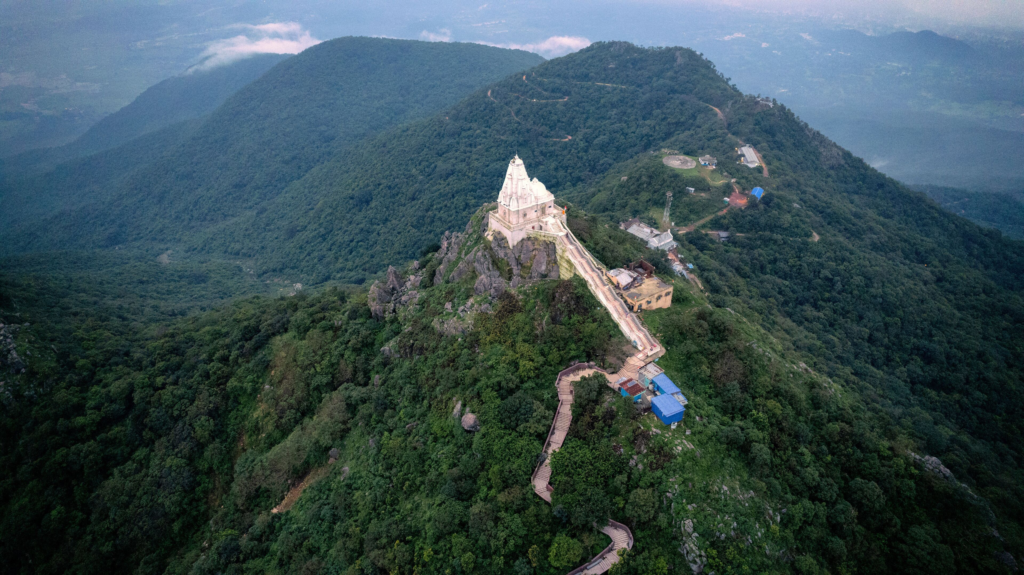
Parasnath is important not only in physical geography but also in the cultural geography of India. Known to Jains as Shikharji or Sammed Shikhar, it is among the holiest pilgrimage landscapes of Jainism. The hill therefore represents an unusual combination of geomorphology, forests, biodiversity, religious geography, tourism and local livelihoods.
For the complete collection of Jharkhand-specific geography and state studies, see JPSC Notes.
Parasnath Hill at a Glance
| Feature | Important Information |
|---|---|
| Name | Parasnath Hill |
| Religious name | Shikharji / Sammed Shikhar |
| District | Giridih |
| State | Jharkhand |
| Approximate elevation | 1,365 metres |
| Status | Highest point of Jharkhand |
| Physiographic region | Eastern Chotanagpur Plateau |
| Landform type | Prominent residual highland |
| Dominant geological setting | Ancient crystalline/metamorphic terrain |
| Major nearby drainage | Barakar-Usri and adjoining river systems |
| Natural vegetation | Tropical deciduous and hill forest |
| Major cultural importance | Jain pilgrimage centre |
| Principal pilgrimage settlement | Madhuban |
| Major economic activities | Pilgrimage, tourism, agriculture and forest-based livelihoods |
| Major environmental concerns | Forest pressure, erosion, waste and tourism-related disturbance |
Location of Parasnath Hill
Parasnath Hill lies in Giridih district of eastern Jharkhand. It rises prominently above the surrounding uplands of North Chotanagpur and forms one of the most easily recognisable relief features of the region.
The hill is located near Madhuban, the principal base for pilgrims travelling to the summit. Giridih town lies to its south-west, while the broader Barakar-Damodar drainage region extends towards the east and south-east.
Its location is significant because Parasnath stands between several contrasting geographical landscapes:
- the Hazaribagh-Giridih uplands;
- the Barakar drainage basin;
- the coal-bearing regions farther south and east;
- the lower plateau margins approaching West Bengal.
Thus, although Parasnath is a single prominent hill, it forms part of a much larger physiographic system.
Get all JPSC Notes https://learnpro.in/jpsc-notes/

Highest Point of Jharkhand
At approximately 1,365 metres above mean sea level, Parasnath is the highest point in Jharkhand.
This distinction needs to be understood carefully. Netarhat and the western Pats represent some of the highest extensive plateau surfaces, but Parasnath rises higher as an individual summit.
The comparison is:
| Feature | Approximate Elevation |
|---|---|
| Parasnath summit | ~1,365 m |
| Netarhat/western Pat surfaces | Often ~900–1,100 m |
| Ranchi Plateau | Generally ~600–700 m |
| Hazaribagh Plateau | Broadly around 600 m |
| Damodar Valley | Significantly lower |
Therefore:
Highest extensive plateau surface → Western Pats
Highest individual point → Parasnath Hill
Parasnath within the Chotanagpur Plateau
Parasnath belongs to the broader Chotanagpur Plateau system, but it does not form a broad tableland like Ranchi or Netarhat. Instead, it rises abruptly above surrounding plateau surfaces as a prominent highland.
The hill demonstrates an important geomorphological principle: long-term erosion does not lower all rocks at the same rate. More resistant rock masses may remain standing while surrounding terrain is gradually reduced.
This process produces:
Unequal rock resistance
↓
Differential erosion
↓
Lowering of surrounding surface
↓
Survival of resistant highland
↓
Residual hill
Parasnath is therefore commonly understood as a major residual relief feature of the eastern Chotanagpur landscape.
Geological Structure
Parasnath is associated with the ancient geological formations of the Chotanagpur region. The surrounding landscape is built largely upon Precambrian crystalline and metamorphic rocks, which have undergone repeated deformation, uplift, weathering and erosion over immense periods of geological time.
Unlike the Rajmahal Hills, Parasnath is not volcanic in origin. It also differs from the Damodar Valley, where younger Gondwana sedimentary rocks contain major coalfields.
The contrast can be summarised as:
| Region | Geological Character |
|---|---|
| Parasnath-Giridih uplands | Ancient crystalline/metamorphic terrain |
| Damodar Valley | Gondwana sedimentary basin |
| Rajmahal Hills | Basaltic volcanic terrain |
| Western Pats | Ancient rocks with deeply weathered lateritic surfaces |
This variation shows the geological complexity of Jharkhand.
Why Parasnath Remained So High
The exceptional prominence of Parasnath is the product of differential erosion. Resistant rocks eroded more slowly than the surrounding formations, allowing the hill mass to remain at a greater elevation.
The process took place over a very long period.
A simplified sequence is:
Ancient upland surface
↓
Long-term weathering
↓
Erosion removes weaker rocks faster
↓
Resistant rock mass survives
↓
Parasnath emerges as prominent residual highland
The present summit therefore represents a remnant of an older and higher land surface.
Relief and Shape
Parasnath is characterised by a prominent elevated mass with steep slopes descending towards the surrounding plateau.
Its relief includes:
- steep hill slopes;
- narrow ridges;
- deeply cut drainage channels;
- rocky exposures;
- forested summit areas;
- saddles between local peaks.
Unlike a single smooth conical mountain, Parasnath consists of a wider highland mass containing several local ridges and summit points.
The difference between summit and surrounding terrain produces substantial relative relief, making the hill visually more impressive than many broad high plateaus.
Relative Relief
Absolute elevation measures height above sea level, whereas relative relief describes the height difference between a summit and nearby valleys or plains.
Parasnath has both:
- high absolute elevation;
- strong relative relief.
This is why the hill appears dramatically elevated even from surrounding plateau areas that are themselves several hundred metres above sea level.
Parasnath and Giridih Uplands
The wider Giridih region consists of dissected uplands, valleys and isolated hills. Parasnath forms the highest and most dominant feature within this landscape.
The terrain surrounding the hill includes:
- agricultural valleys;
- forested uplands;
- rocky ridges;
- tributaries of larger river systems.
Thus, the hill does not exist in isolation but forms part of an extensive upland-valley landscape.
Drainage around Parasnath
Numerous small streams originate on or around the slopes of Parasnath. These streams descend rapidly because of the steep gradient and eventually join larger drainage systems of Giridih and adjoining regions.
The wider region is influenced mainly by the Barakar drainage system and several local tributaries, while the Usri River is an important river of the Giridih region.
Rainfall on the summit and upper slopes therefore contributes to downstream:
- streams;
- agricultural water;
- groundwater recharge;
- river flow.
The hill functions locally as an important catchment and watershed.
Effects of Steep Gradient on Streams
Streams descending from Parasnath have relatively steep upper courses.
Steep gradient results in:
- rapid flow;
- strong erosional power;
- narrow channels;
- movement of rock fragments and sediment.
During the monsoon, stream discharge increases substantially.
During the dry season, many smaller channels carry much less water.
This strong seasonal variation is characteristic of plateau and hill drainage throughout Jharkhand.
Parasnath and the Barakar Basin
The Barakar River system is one of the most important drainage systems in the broader Giridih region. It ultimately joins the Damodar and therefore connects the Parasnath-Giridih uplands with the much larger Damodar basin.
The geographical chain is broadly:
Parasnath and Giridih uplands
↓
Local streams
↓
Barakar and related tributaries
↓
Damodar
↓
Lower eastern drainage
The hill therefore lies within a wider hydrological system extending well beyond Giridih district.
For a broader understanding of river systems, see Drainage System of Jharkhand.
Usri River and Waterfall
The Usri River is an important river of the Giridih region and forms the well-known Usri Falls near Giridih.
The waterfall develops where the river descends across a resistant rocky surface. Although it is not directly on the summit of Parasnath, it belongs to the same broader dissected plateau landscape.
Its existence demonstrates the same geomorphological relationship found elsewhere in Jharkhand:
Hard plateau rock + river gradient + differential erosion → waterfall
The Giridih region therefore contains both major hills and significant erosional river landforms.
Climate of Parasnath Hill
The climate of Parasnath differs noticeably between the summit and surrounding lower areas because of elevation. Temperatures decrease with increasing altitude, giving the upper hill a relatively cooler climate.
The broader seasonal pattern is:
| Season | Approximate Period | General Condition |
|---|---|---|
| Summer | March–May | Warm in lower areas, milder at higher elevations |
| Monsoon | June–September | Wet, humid and cloudy |
| Post-Monsoon | October–November | Pleasant |
| Winter | December–February | Cool, particularly on summit |
During winter, summit temperatures can be substantially lower than those of the nearby valleys.
Temperature and Altitude
The basic climatic relationship is:
Increase in elevation → decrease in temperature
Since the summit stands more than a kilometre above sea level, temperature at higher elevations can be several degrees lower than nearby lowlands.
Altitude also influences:
- wind exposure;
- cloud formation;
- humidity;
- evaporation.
This creates local climatic zones from the foothills to the summit.
Monsoon Rainfall
Most rainfall occurs during the south-west monsoon. Moist air rising along the hill slopes can enhance local condensation and cloud formation.
Heavy rainfall has several effects:
- replenishes streams;
- supports forest vegetation;
- recharges local groundwater;
- increases soil erosion on exposed slopes.
The effect of rainfall therefore depends heavily on forest cover.
Orographic Influence
When moisture-bearing air encounters an elevated hill, it is forced upward. As the air rises, it cools and can produce additional cloud and rainfall.
This phenomenon is called orographic uplift.
Although Parasnath is not a massive mountain barrier comparable to the Western Ghats or Himalayas, its considerable local elevation can still influence rainfall and cloud formation around the hill.
Soils of Parasnath
Soils vary considerably from the summit to the foothills.
Upper Slopes
Generally contain:
- shallow soils;
- rocky material;
- strong drainage;
- high erosion risk.
Gentler Lower Slopes
Contain:
- deeper weathered soils;
- more organic material;
- better agricultural potential.
Valleys
Contain:
- transported sediments;
- deeper soil profiles;
- greater moisture retention.
Relief therefore determines soil depth and agricultural suitability.
Soil Erosion
Steep slopes make Parasnath particularly vulnerable to soil erosion if vegetation is disturbed.
Rainfall falling on exposed slopes can quickly generate surface runoff.
The sequence is:
Vegetation removal
↓
Bare soil exposed
↓
Heavy monsoon rainfall
↓
Rapid runoff
↓
Soil erosion
↓
Sedimentation downstream
Forest conservation is therefore essential for maintaining the hill’s soil stability.
Natural Vegetation
Parasnath supports substantial tropical deciduous forest vegetation, modified by altitude, slope, soil and human use.
Important species in the broader landscape include:
- Sal;
- mahua;
- palash;
- bamboo;
- mixed deciduous species.
Vegetation tends to be denser on less disturbed slopes and in locations where soil and moisture conditions are favourable.
Altitudinal Variation in Vegetation
The difference in elevation from foothills to summit creates local changes in vegetation structure.
Lower slopes experience:
- higher temperature;
- greater human pressure;
- more agricultural conversion.
Upper slopes tend to experience:
- cooler conditions;
- greater exposure;
- thinner soils;
- more restricted cultivation.
These differences contribute to a mosaic of forest and scrub habitats.
Forests as Watershed Protection
Forest vegetation performs particularly important hydrological functions on Parasnath.
Trees and forest litter:
- reduce the speed of surface runoff;
- improve infiltration;
- protect soil;
- support groundwater recharge;
- regulate stream flow.
Loss of upper-slope forest would therefore affect not only biodiversity but also downstream water availability.
Wildlife and Biodiversity
The forested hill provides habitat for a variety of wildlife characteristic of the Chotanagpur Plateau.
The broader landscape supports species such as:
- deer;
- wild boar;
- langurs and monkeys;
- small carnivores;
- reptiles;
- numerous birds.
Forest patches on prominent hills often function as important ecological refuges within more heavily cultivated surrounding landscapes.
Ecological Isolation
One challenge for hill ecosystems is their increasing isolation from larger continuous forest blocks.
Agricultural expansion, roads and settlements may divide habitat into separate patches. This reduces movement between populations and can gradually reduce biodiversity.
Ecological conservation therefore needs to consider:
- the summit forest;
- lower slopes;
- connecting forest patches;
- stream corridors.
Protecting only the highest part of the hill is insufficient.
Religious Geography of Parasnath
Parasnath is known in Jain tradition as Shikharji or Sammed Shikhar and is regarded as one of Jainism’s most sacred pilgrimage centres.
The religious significance comes from the belief that twenty of the twenty-four Jain Tirthankaras attained liberation in the Shikharji landscape.
Pilgrimage therefore transforms the hill into a cultural landscape in which:
- peaks;
- paths;
- temples;
- forest;
- water sources
all possess religious significance.
Shikharji
The name Shikharji literally reflects the importance of the hill’s peaks. Pilgrims undertake a demanding journey through the forested hill to visit numerous sacred sites.
The pilgrimage landscape includes several tonks, or shrines associated with individual Jain Tirthankaras and other revered figures.
The religious geography is therefore spread across the hill rather than concentrated at a single temple.
Madhuban
Madhuban, situated at the base of Parasnath, functions as the principal gateway to Shikharji.
The settlement contains:
- temples;
- dharamshalas;
- pilgrim facilities;
- markets;
- accommodation;
- transport services.
Its economy is closely related to pilgrimage activity.
The relationship is:
Sacred hill
↓
Pilgrimage
↓
Madhuban service economy
This makes Madhuban an important example of a settlement whose economic geography is shaped by religious tourism.
Pilgrimage Route
Pilgrims generally begin their ascent from Madhuban and follow a long route through the hill landscape.
The journey involves considerable elevation gain and can extend over many kilometres as pilgrims visit different sacred sites.
The route passes through:
- forest;
- steep paths;
- ridge sections;
- summit areas.
Physical geography therefore directly shapes the religious experience.
Cultural Landscape
A cultural landscape is created when human beliefs and activities give special meaning to a natural environment.
Parasnath is an excellent example because the hill is simultaneously:
- a geological landform;
- a forest ecosystem;
- a watershed;
- a pilgrimage route;
- a sacred landscape.
Natural and cultural geography are inseparable here.
Local Communities
The wider Giridih-Parasnath region contains numerous rural and tribal settlements. Communities depend to varying degrees on:
- agriculture;
- forest resources;
- tourism;
- wage labour;
- local trade.
Forest access and conservation regulations can therefore have direct implications for local livelihoods.
For broader coverage of Jharkhand’s indigenous communities, see Tribes of Jharkhand.
Agriculture around Parasnath
Agriculture is concentrated mainly on gentler lower slopes and surrounding valleys.
Important crops include:
- paddy;
- maize;
- pulses;
- oilseeds;
- vegetables.
Steep upper slopes are generally unsuitable for intensive cultivation because of shallow soils and erosion risk.
Thus:
Steep upper slope → forest
Gentle lower slope → mixed cultivation
Valley bottom → paddy
This relationship is typical of Jharkhand’s hill geography.
Settlement Pattern
Settlements are concentrated mainly around:
- foothills;
- valleys;
- transport routes;
- water sources.
Very steep slopes have relatively little permanent settlement.
The pattern demonstrates the influence of topography:
Gentle terrain + water + agricultural land → denser settlement
Steep rocky terrain → sparse settlement
Pilgrimage has created an additional concentration of population and services around Madhuban.
Economic Importance of Parasnath
The hill’s economic importance arises principally from:
- pilgrimage tourism;
- forest-based livelihoods;
- local agriculture;
- transport and hospitality;
- small commercial activities.
Unlike Dhanbad or Singhbhum, Parasnath is not primarily a mineral-industrial landscape.
Its principal economic asset is its combination of natural and religious significance.
Pilgrimage Economy
Thousands of visitors travelling to Shikharji create demand for:
- accommodation;
- food;
- transport;
- guides;
- religious goods;
- local services.
This supports employment around Madhuban and surrounding settlements.
However, large visitor numbers can also generate environmental pressure.
Tourism Geography
Parasnath attracts not only religious pilgrims but also visitors interested in:
- forests;
- hill scenery;
- trekking;
- regional culture.
Its elevation provides expansive views over the surrounding plateau.
The tourism potential depends on maintaining:
- clean trails;
- forest cover;
- landscape quality;
- water sources.
Environmental degradation would therefore directly reduce tourism value.
Transport Connectivity
The Parasnath region is connected with the wider rail and road network of eastern India.
Parasnath railway station, located in the broader region, provides an important access point for visitors travelling from distant parts of the country. From there, road transport connects pilgrims with Madhuban and the base of the hill.
The hill’s religious importance has therefore encouraged stronger transport connections than might otherwise be expected for a mountainous rural landscape.
Environmental Pressure from Pilgrimage
Large-scale pilgrimage can create environmental problems if facilities are poorly managed.
Major concerns include:
- plastic waste;
- food waste;
- trail erosion;
- disturbance of wildlife;
- pressure on water sources;
- construction.
The challenge is to accommodate pilgrims while maintaining the ecological character of the sacred hill.
Waste Management
Waste is particularly difficult to manage on high and inaccessible terrain.
Materials carried uphill ultimately need to be:
- collected;
- segregated;
- transported;
- safely processed.
Uncontrolled disposal can affect:
- streams;
- wildlife;
- soil;
- scenic quality.
A carry-in, carry-out approach for non-biodegradable waste can substantially reduce pressure on the summit landscape.
Forest Conservation and Religious Values
The sacred status of Shikharji can support conservation because many religious traditions emphasise respect for living organisms and natural surroundings.
This provides an opportunity to combine:
religious conservation values
scientific ecological management
Such cooperation can help protect forests while improving the pilgrimage experience.
Fire Risk
Dry deciduous forests become vulnerable to fire during the late winter and summer months.
Forest fires may be caused by:
- accidental ignition;
- discarded burning materials;
- deliberate burning;
- prolonged dry weather.
Fire can damage:
- young trees;
- soil organisms;
- wildlife habitat;
- regeneration.
Pilgrimage and tourism management therefore needs strong fire-prevention measures.
Water Availability
Water supply can become difficult at higher elevations, particularly outside the monsoon season.
Streams fluctuate seasonally, while groundwater access becomes more difficult on steep rocky terrain.
Water conservation therefore depends on:
- protecting springs;
- maintaining forests;
- rainwater harvesting;
- controlling contamination.
Visitor demand can place additional pressure on limited local sources.
Geomorphological Importance
Parasnath is an important example of a residual mountain or residual hill within an old plateau landscape.
Its existence demonstrates:
- differential erosion;
- rock resistance;
- prolonged denudation;
- relief inversion and preservation of resistant uplands.
The hill therefore provides a useful contrast with:
- broad plateaus;
- structural basins;
- volcanic hills.
Parasnath vs Rajmahal Hills
| Feature | Parasnath Hill | Rajmahal Hills |
|---|---|---|
| Location | Giridih | Sahibganj-Santhal Pargana |
| Highest elevation | ~1,365 m | Generally much lower |
| Origin | Residual highland | Volcanic |
| Main geology | Ancient crystalline/metamorphic rocks | Basalt |
| Major importance | Highest point and Jain pilgrimage | Rajmahal Traps and volcanic geology |
| Main economic association | Pilgrimage tourism | Stone quarrying, agriculture |
The two hill systems therefore represent entirely different geomorphological processes.
Parasnath vs Netarhat
| Feature | Parasnath | Netarhat |
|---|---|---|
| Type | Isolated/prominent highland | Broad high plateau |
| Elevation | ~1,365 m summit | Around ~1,000 m general surface |
| District | Giridih | Latehar |
| Geographical region | Eastern Chotanagpur | Western Pat region |
| Economic importance | Pilgrimage and tourism | Tourism, forestry, agriculture |
| Major geological identity | Resistant residual hill | High weathered plateau surface |
Parasnath is higher, but Netarhat covers a much larger elevated surface.
Parasnath vs Ranchi Plateau
Parasnath rises roughly 700 metres above the typical elevation of the Ranchi Plateau.
Ranchi Plateau:
- broad;
- urbanised;
- agricultural;
- around 600–700 m.
Parasnath:
- steep;
- forested;
- much higher;
- primarily a sacred hill landscape.
This comparison demonstrates the enormous local relief variation within Jharkhand.
Parasnath and Mica Belt
Giridih lies within the broader Koderma-Giridih mineral region, historically associated with mica-bearing pegmatites.
However, the geographical importance of Parasnath itself should not be reduced to mineral extraction. The hill is more significant for:
- relief;
- forest;
- watershed functions;
- religion;
- tourism.
Mining and quarrying close to environmentally sensitive hills can create significant landscape pressures.
Conservation Importance
Parasnath requires careful conservation because several forms of value overlap within a relatively compact area.
These include:
- geological value;
- biodiversity;
- watershed protection;
- Jain religious significance;
- tourism;
- local livelihoods.
Damage to one element can affect all the others.
For example:
Deforestation
↓
Erosion
↓
Reduced water retention
↓
Damage to habitat
↓
Reduced pilgrimage and tourism quality
Conservation therefore needs a landscape-scale approach.
Major Peaks and High Points of Jharkhand
Parasnath should also be understood in relation to Jharkhand’s other important highlands.
| Highland | Location | Approximate Significance |
|---|---|---|
| Parasnath/Shikharji | Giridih | Highest point – ~1,365 m |
| Netarhat Plateau | Latehar | High extensive plateau around 1,000 m |
| Western Pats | Latehar-Gumla-Lohardaga | High flat-topped surfaces |
| Dalma Hills | East Singhbhum | Important eastern hill range |
| Rajmahal Hills | Sahibganj | Volcanic hill system |
These landforms have different geological origins and should not be treated as one uniform hill system.
Why Parasnath Is Higher than Surrounding Terrain
The height of Parasnath results mainly from the survival of more resistant geological formations during prolonged erosion.
Over millions of years:
surrounding rocks were lowered more rapidly
while
resistant rocks remained comparatively elevated
The result is a high residual feature rising sharply above an otherwise eroded plateau.
This is an important example of differential denudation.
Role in Regional Geography
Parasnath affects the surrounding region in several ways.
Physical
It influences:
- drainage;
- slope;
- local climate;
- forest distribution.
Economic
It supports:
- pilgrimage;
- tourism;
- local trade;
- services.
Cultural
It forms:
- a major Jain sacred landscape.
Environmental
It protects:
- forests;
- soils;
- local water catchments.
Its geographical influence therefore extends far beyond the summit itself.
Parasnath Hill: Core Data Table
| Indicator | Key Information |
|---|---|
| District | Giridih |
| Alternative names | Shikharji, Sammed Shikhar |
| Approximate elevation | 1,365 m |
| State ranking | Highest point of Jharkhand |
| Physiographic system | Chotanagpur Plateau |
| Landform | Residual highland |
| Broad geological setting | Ancient crystalline/metamorphic terrain |
| Major drainage association | Barakar-Usri region |
| Dominant vegetation | Tropical deciduous forest |
| Major religious association | Jainism |
| Pilgrimage base | Madhuban |
| Main economic significance | Pilgrimage and tourism |
| Major ecological role | Forest and watershed conservation |
| Major environmental concerns | Erosion, waste, forest degradation and tourism pressure |
Geographical Significance of Parasnath Hill
Parasnath is significant because it demonstrates how geological resistance, prolonged erosion and plateau evolution can produce a prominent residual highland. At approximately 1,365 metres, it stands considerably above most of Jharkhand and forms the highest individual point in the state.
Its physical geography has also shaped human geography. The steep and forested landscape became one of Jainism’s most sacred pilgrimage areas, while Madhuban developed as a service settlement at its base. Forests protect the hill’s soils and water catchments, making ecological conservation essential for both local communities and pilgrims.
The geography of Parasnath can therefore be summarised as:
Ancient resistant rocks
↓
Differential erosion
↓
High residual hill
↓
Distinctive forest and watershed
↓
Sacred landscape
↓
Pilgrimage and tourism economy
Parasnath is consequently much more than Jharkhand’s highest point. It is a landscape where geology, relief, ecology, religion and economic activity interact directly.
Frequently Asked Questions (FAQs)
1. Where is Parasnath Hill located?
Parasnath Hill is located in Giridih district of Jharkhand.
2. What is another name for Parasnath Hill?
It is also known as Shikharji or Sammed Shikhar.
3. What is the elevation of Parasnath Hill?
Its summit rises to approximately 1,365 metres above mean sea level.
4. Is Parasnath the highest point of Jharkhand?
Yes. Parasnath is the highest point of Jharkhand.
5. Is Netarhat higher than Parasnath?
No. Netarhat forms a high extensive plateau surface, but Parasnath has the higher individual summit.
6. Which physiographic region contains Parasnath?
It forms part of the broader Chotanagpur Plateau landscape.
7. What type of landform is Parasnath?
It is a prominent residual highland or residual hill.
8. How was Parasnath formed?
Differential erosion lowered surrounding weaker rocks more rapidly, leaving resistant formations standing at greater elevation.
9. Is Parasnath volcanic?
No. It should not be confused with the volcanic Rajmahal Hills.
10. Which geological formations broadly underlie the Parasnath region?
The region belongs to the ancient crystalline and metamorphic geological terrain of Chotanagpur.
11. Which major river basin is associated with the wider Giridih region?
The Barakar-Damodar system is particularly important.
12. Which important river flows near Giridih?
The Usri River is an important river of the Giridih region.
13. Does the region have a waterfall?
Yes. Usri Falls is an important waterfall near Giridih.
14. Why is Parasnath cooler than surrounding lowlands?
Its high elevation causes temperatures to decrease towards the summit.
15. What type of climate occurs?
It has a tropical monsoon climate modified strongly by altitude.
16. When does Parasnath receive most rainfall?
Most rainfall occurs during the south-west monsoon from June to September.
17. What type of forests occur?
The hill supports predominantly tropical deciduous vegetation.
18. Which tree is common in the wider region?
Sal is an important characteristic tree of Jharkhand’s deciduous forests.
19. Why are forests important on Parasnath?
They protect soil, regulate runoff, maintain biodiversity and help recharge water sources.
20. Why is Parasnath important in Jainism?
Known as Shikharji, it is one of the holiest Jain pilgrimage sites and is traditionally associated with the liberation of twenty Tirthankaras.
21. What is Madhuban?
Madhuban is the principal settlement and pilgrimage base at the foot of Parasnath.
22. What are tonks?
Tonks are sacred shrines located along the Shikharji pilgrimage landscape.
23. What are the main economic activities around Parasnath?
Important activities include pilgrimage tourism, hospitality, agriculture, trade and forest-based livelihoods.
24. Why is intensive cultivation limited on the upper slopes?
The slopes are steep and contain shallow, erosion-prone soils.
25. Where is agriculture concentrated?
Agriculture is concentrated on gentler lower slopes and surrounding valleys.
26. What is the difference between Parasnath and Rajmahal Hills?
Parasnath is a high residual feature of ancient plateau terrain, whereas the Rajmahal Hills are volcanic basaltic hills.
27. What is the difference between Parasnath and Netarhat?
Parasnath is an individual high summit at about 1,365 m, whereas Netarhat is a broad high plateau generally around 1,000 m.
28. What are the major environmental threats to Parasnath?
Important concerns include forest degradation, soil erosion, waste generation, tourism pressure and disturbance of water sources.
29. Why is Parasnath important as a watershed?
Its forested high slopes collect rainfall and feed numerous streams flowing towards surrounding valleys and larger river systems.
30. Why is Parasnath important in Jharkhand Geography?
Parasnath is important because it is Jharkhand’s highest point, a major residual landform, an important forested watershed and one of India’s most important Jain sacred landscapes.





