
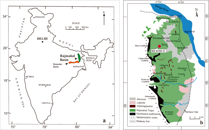
The Rajmahal Hills form one of the most distinctive physiographic and geological regions of Jharkhand. Located mainly in Sahibganj district and extending into adjoining parts of the Santhal Pargana region, these hills are fundamentally different from the ancient crystalline plateaus of Ranchi, Hazaribagh and Singhbhum. While much of the Chotanagpur Plateau is composed of very old Precambrian rocks, the Rajmahal Hills are built largely of basaltic lava flows known as the Rajmahal Traps, produced by extensive volcanic activity during the Early Cretaceous period.
The hills occupy an important position near the Ganga valley in north-eastern Jharkhand. Their volcanic origin, terraced slopes, forest cover, narrow valleys and proximity to the Ganga create a geographical landscape unlike any other major region of the state. The Rajmahal Hills are also important for understanding the geological evolution of eastern India, the break-up of Gondwana, the drainage history of the Ganga basin and the settlement geography of the Paharia and Santhal-dominated areas of Santhal Pargana.
For the broader collection of state-specific material, see JPSC Notes.
Rajmahal Hills at a Glance
| Feature | Important Information |
|---|---|
| Location | North-eastern Jharkhand |
| Principal district | Sahibganj |
| Wider region | Santhal Pargana |
| Geological formation | Rajmahal Traps |
| Dominant rock | Basalt |
| Origin | Volcanic |
| Major geological age | Early Cretaceous |
| Approximate age of volcanism | Around 118–115 million years ago |
| General relief | Dissected volcanic hills and plateaus |
| Highest local elevations | Several hilltops exceed 400–500 m |
| Northern geographical feature | Ganga valley |
| Important drainage | Short streams flowing towards the Ganga and adjoining basins |
| Natural vegetation | Tropical deciduous forest |
| Important communities | Sauria Paharia, Mal Paharia, Santhal and others |
| Major economic activities | Agriculture, stone quarrying, forest-based livelihoods |
| Major environmental concerns | Quarrying, deforestation, soil erosion and habitat degradation |
Location of the Rajmahal Hills
The Rajmahal Hills lie in the north-eastern corner of Jharkhand, principally in Sahibganj district and adjoining areas of the Santhal Pargana. They form an elongated belt of hills close to the southern bank of the Ganga.
The geographical position of the hills is particularly important because the Ganga makes a major bend around the Rajmahal region before continuing eastward towards West Bengal. The hills therefore stand close to one of India’s largest river systems while remaining physically distinct from the surrounding alluvial plains.
Broadly, the region is bordered by:
- the Ganga valley towards the north and north-east;
- lower Santhal Pargana uplands towards the south;
- the Bengal plain towards the east;
- plateau and dissected uplands towards the west.
This location makes Rajmahal a meeting zone of volcanic hills, river plains and eastern plateau landscapes.
Get all JPSC Notes https://learnpro.in/jpsc-notes/

Rajmahal Hills and the Chotanagpur Plateau
The Rajmahal Hills are generally included within the broader physical geography of Jharkhand, but geologically they are quite different from the main Chotanagpur Plateau.
The distinction is important:
| Chotanagpur Plateau | Rajmahal Hills |
|---|---|
| Mainly Precambrian crystalline rocks | Mainly basaltic volcanic rocks |
| Granite, gneiss, schist, quartzite | Basalt and associated volcanic formations |
| Extremely ancient geological basement | Much younger Mesozoic volcanism |
| Erosional plateau | Volcanic plateau/hill landscape |
| Major metallic mineral belts | Important stone and basalt resources |
Thus, the Rajmahal Hills should not be treated simply as another extension of the Ranchi or Hazaribagh Plateau.
Geological Origin of the Rajmahal Hills
The Rajmahal Hills were formed by extensive fissure volcanic eruptions during the Early Cretaceous period, approximately 118–115 million years ago. Lava emerged repeatedly through long fractures in the Earth’s crust rather than from a single central volcanic cone.
Successive lava flows spread across the surface and cooled into thick layers of basalt. Repetition of this process produced a large volcanic province.
The basic sequence was:
Crustal fracturing
↓
Basaltic magma rose through fissures
↓
Extensive lava flows spread over the surface
↓
Repeated eruptions produced multiple basalt layers
↓
Weathering and erosion dissected the lava plateau
↓
Present Rajmahal Hills
The modern hills are therefore remnants of a much larger volcanic surface.
Rajmahal Traps
The basaltic formations of the hills are known collectively as the Rajmahal Traps. The word “trap” comes from a term meaning steps or stairs and is used for landscapes produced by multiple horizontal or nearly horizontal lava flows.
Because individual lava flows have different resistance to erosion, weathering often produces a step-like or terraced relief.
The Rajmahal Traps consist mainly of:
- basalt;
- doleritic rocks;
- volcanic flows;
- intertrappean sedimentary layers in places.
These rocks record one of the major volcanic episodes in the geological history of eastern India.
Age of the Rajmahal Traps
The main Rajmahal volcanic episode occurred during the Early Cretaceous, more than 110 million years ago. Modern geological dating places important phases of the volcanism broadly around 118–115 million years ago.
This makes the Rajmahal Traps:
- much younger than the Precambrian rocks of Singhbhum and Ranchi;
- older than the Himalayan mountain-building phase;
- associated with major tectonic changes during the break-up of Gondwana.
The age difference is critical for understanding Jharkhand’s geological diversity.
Connection with the Break-up of Gondwana
The Rajmahal volcanism occurred during a period when the ancient supercontinent Gondwana was breaking apart. The Indian landmass was separating from other southern continents and beginning its long northward movement.
Tectonic stretching and fracturing allowed magma from the Earth’s interior to reach the surface. This resulted in widespread basaltic eruptions.
The broad tectonic sequence was:
Gondwana fragmentation
↓
Crustal extension
↓
Development of deep fractures
↓
Magma ascent
↓
Rajmahal volcanism
This makes the Rajmahal Hills important not merely for Jharkhand geography but also for reconstructing the movement of the Indian Plate.
Rajmahal-Sylhet Volcanic Province
The Rajmahal volcanic formations are geologically connected with volcanic rocks extending eastward towards the Sylhet region. Today these areas are separated geographically, but their rock formations preserve evidence of the same broad tectonic episode.
This indicates that the original volcanic province was much more extensive than the hills visible in present-day Jharkhand.
Subsequent:
- erosion;
- sediment deposition;
- tectonic movements;
- river development
fragmented and buried large portions of the original volcanic terrain.
Physical Relief of the Rajmahal Hills
The Rajmahal region consists of dissected hills, ridges, small plateaus and narrow valleys. Although the hills do not reach the extreme elevations of Parasnath or Netarhat, they rise distinctly above the surrounding lowlands.
Many hilltops lie between roughly 200 and 500 metres, with some local summits rising higher than the surrounding terrain.
The relief is characterised by:
- flat or gently rounded summits;
- steep slopes;
- step-like basalt terraces;
- deeply cut stream valleys;
- isolated ridges.
This relief is a result of prolonged erosion of the original volcanic plateau.
Why the Rajmahal Hills Have Stepped Slopes
Repeated lava eruptions produced separate layers of basalt. Some lava layers are harder and more resistant to erosion than others.
Over time:
Hard basalt layer → remains as ledge
Softer/weathered layer → erodes more rapidly
This differential erosion creates a staircase-like appearance.
The stepped terrain is therefore directly related to the layered volcanic structure of the Rajmahal Traps.
North-South Arrangement of the Hills
The Rajmahal hills form a broadly elongated belt rather than a single compact mountain mass. Individual hill blocks are separated by valleys and lower surfaces.
This elongated arrangement reflects:
- volcanic structure;
- fractures;
- river erosion;
- subsequent denudation.
The hill system creates a marked physical barrier between certain parts of Santhal Pargana and the Ganga valley.
Rajmahal Hills and the Ganga
One of the most important geographical features of the region is the close relationship between the hills and the Ganga River. Near Rajmahal and Sahibganj, the river flows close to the hill margins.
This produces a striking contrast:
Rocky volcanic hills
↓
Narrow transitional belt
↓
Broad Ganga alluvial plain
The proximity of the hills historically influenced:
- river routes;
- settlement;
- military movement;
- trade;
- agriculture.
The Ganga corridor gave Rajmahal considerable strategic importance in earlier periods.
The Ganga Bend near Rajmahal
The Ganga changes its general direction significantly in the broader Rajmahal region. Historically, this bend made the area an important landmark for river navigation.
The interaction between hard rock structures and softer surrounding sediments has played an important role in the evolution of the river course.
The modern Ganga valley near Sahibganj contains:
- floodplains;
- river islands;
- sediment deposits;
- channels influenced by seasonal discharge.
This landscape differs sharply from the rocky terrain only a short distance away.
Drainage of the Rajmahal Hills
The hills are drained by numerous short seasonal streams. Because the relief is steep, rainfall quickly moves down the slopes into valleys.
Some streams flow directly or indirectly towards the Ganga, while others contribute to drainage systems farther south and east.
The drainage pattern is strongly influenced by:
- fractures in basalt;
- slope direction;
- differential erosion;
- local valleys.
The streams generally have much smaller catchments than major plateau rivers such as the Damodar or Subarnarekha.
Seasonal Nature of Streams
Most small hill streams show substantial seasonal variation.
During the Monsoon
They may experience:
- strong flow;
- rapid runoff;
- erosion;
- local flooding.
During the Dry Season
Many become:
- shallow;
- intermittent;
- confined to pools and small channels.
Thus, local communities may face water scarcity even though heavy rainfall occurs during the monsoon.
Climate of the Rajmahal Hills
The region has a tropical monsoon climate. Because the hills lie at generally lower elevations than Netarhat and Parasnath, summers can become hot and humid, particularly in valleys and adjoining plains.
The seasonal cycle is broadly:
| Season | Approximate Period | Main Character |
|---|---|---|
| Summer | March–May | Hot |
| South-West Monsoon | June–September | Humid and rainy |
| Post-Monsoon | October–November | Warm to pleasant |
| Winter | December–February | Cool and relatively dry |
Elevation produces local differences between hilltops and valleys, but the contrast is not as pronounced as between Netarhat and Palamu.
Rainfall
The Rajmahal-Santhal Pargana region receives most of its rainfall from the south-west monsoon. Eastern Jharkhand generally benefits from greater access to moisture-bearing monsoon currents than some drier western interiors.
Rainfall supports:
- forests;
- rainfed agriculture;
- seasonal streams;
- groundwater recharge.
However, steep slopes and shallow soils can generate considerable surface runoff.
Soils of the Rajmahal Hills
The soils of the Rajmahal region differ from those developed over the granite-gneiss terrain of central Jharkhand. Weathering of basalt produces soils with a somewhat different mineral composition.
Major soil environments include:
- reddish-brown upland soils;
- shallow stony hill soils;
- deeper valley soils;
- alluvial soils near the Ganga.
Soil depth varies dramatically with relief.
Hill Slopes
Generally contain:
- shallow soil;
- abundant rock fragments;
- high erosion risk.
Valley Floors
Contain:
- deeper soil;
- transported sediment;
- better moisture availability.
Ganga Plain
Contains:
- younger alluvium;
- deeper agricultural soils;
- greater cultivation intensity.
This creates a strong contrast between hill and plain agriculture.
Soil Erosion
The Rajmahal Hills are particularly susceptible to erosion where vegetation has been removed. Heavy monsoon rain can wash soil rapidly down steep slopes.
Major causes include:
- deforestation;
- quarrying;
- cultivation on slopes;
- exposed rock surfaces;
- poorly managed drainage.
The consequences include:
- thinning of soils;
- gully formation;
- sedimentation of valleys;
- decline in agricultural productivity.
Maintaining vegetation cover on slopes is therefore extremely important.
Natural Vegetation
The natural vegetation belongs mainly to the tropical deciduous forest type. Forest cover is uneven because large areas have been modified by agriculture, settlement and quarrying.
Important tree and plant species include:
- Sal in suitable areas;
- mahua;
- palash;
- bamboo;
- kendu;
- mixed dry-deciduous species.
The structure of the forest varies with elevation, soil depth and human pressure.
Forests and Hill Slopes
Forests survive more extensively on steep and less accessible slopes where agriculture is difficult.
The pattern can be summarised as:
Steep rocky slope → forest
Gentle lower slope → shifting/settled cultivation
Valley floor → agriculture and settlement
This topographic relationship has shaped traditional land use for generations.
Rajmahal Hills and Tribal Geography
The Rajmahal Hills are closely associated with the Paharia communities, particularly the Sauria Paharia and Mal Paharia, who historically occupied hill and forest landscapes of the region.
Their settlement pattern differed from that of agricultural populations concentrated in the valleys and plains. Hilltop and slope settlements were shaped by:
- accessibility;
- water;
- forest resources;
- security;
- agricultural land.
The later expansion of the Santhal population across Santhal Pargana added another important element to the human geography of the region.
For broader information on indigenous communities of the state, see Tribes of Jharkhand.
Paharia Settlement Pattern
Paharia communities historically developed settlements in relatively inaccessible hill terrain. The physical isolation of the Rajmahal Hills allowed many communities to maintain distinctive social and economic practices for long periods.
Traditional livelihoods combined:
- small-scale agriculture;
- forest collection;
- hunting in earlier periods;
- grazing;
- exchange with nearby plains.
The hills therefore functioned both as a resource base and as a geographical refuge.
Santhal Expansion into the Region
The broader Santhal Pargana subsequently experienced increasing Santhal settlement, especially in valleys and more cultivable areas. The difference in preferred settlement zones reflected differences in agriculture and land-use systems.
A broad spatial distinction historically developed between:
Paharia hill settlements
and
Santhal agricultural expansion into valleys and cleared areas
This interaction became extremely important in the later social and political history of Santhal Pargana.
Agriculture
Agriculture varies according to relief. The steep hills offer relatively limited opportunities for intensive farming, while lower valleys and adjoining plains are much more suitable.
Important crops include:
- paddy;
- maize;
- pulses;
- oilseeds;
- millets in suitable uplands.
Agriculture remains highly dependent on monsoon rainfall.
Hill Agriculture
Cultivation on slopes faces several constraints:
- shallow soils;
- erosion;
- limited irrigation;
- rapid runoff;
- scattered fields.
As a result, agricultural productivity is generally lower than in deeper valley or alluvial soils.
Traditional cultivation practices were adapted to local terrain, but shortening fallow periods and population pressure can increase degradation where slopes are intensively used.
Agriculture in the Ganga-side Plains
Near the Ganga, the terrain becomes considerably flatter and soils become deeper and more alluvial.
These areas support more intensive cultivation because they generally offer:
- deeper soils;
- better moisture conditions;
- flatter terrain;
- easier transportation.
The contrast between hill agriculture and Ganga plain agriculture is one of the clearest geographical differences within Sahibganj district.
Stone Resources
The basaltic rocks of the Rajmahal Hills provide abundant hard stone suitable for construction and road materials. This has encouraged extensive quarrying and stone-crushing activities in parts of Sahibganj and Pakur-adjoining regions.
Stone is used for:
- road construction;
- railway ballast;
- building aggregate;
- infrastructure development.
The resource has significant economic value but has also created serious environmental concerns.
Stone Quarrying
Large-scale quarrying can reshape the physical landscape by cutting into hill slopes and removing entire sections of rock.
Potential impacts include:
- destruction of hill profiles;
- dust pollution;
- noise;
- forest loss;
- soil erosion;
- alteration of drainage;
- habitat fragmentation.
Because the hills themselves are the geological resource being extracted, excessive quarrying can permanently alter the physiography.
Rajmahal Hills and Pakur Stone Belt
The broader north-eastern Jharkhand region adjoining the Rajmahal volcanic province includes major stone-quarrying belts around Pakur. Dark hard rock from this region is widely used as construction aggregate.
Although Pakur and the central Rajmahal Hills are not identical geographical units, they belong to the broader hard-rock landscape of north-eastern Jharkhand.
Stone extraction has generated:
- employment;
- transport activity;
- crusher industries;
- revenue.
At the same time, uncontrolled quarrying can cause substantial environmental degradation.
Fossils and Intertrappean Beds
One of the most scientifically important aspects of the Rajmahal region is the occurrence of sedimentary layers between lava flows, known as intertrappean beds.
These layers sometimes preserve fossil plant remains. Fossils help reconstruct the vegetation and climate that existed between separate volcanic eruptions.
The sequence may be:
Lava flow
↓
Period without eruption
↓
Sediment and vegetation accumulate
↓
Another lava flow covers the surface
↓
Organic remains become preserved
Such deposits provide valuable evidence about the environmental history of the Early Cretaceous period.
Fossil Flora of Rajmahal
The Rajmahal region is well known in Indian geology for fossil plant remains associated with Gondwana-Mesozoic vegetation. These fossils have helped geologists understand ancient plant communities and palaeoclimatic conditions.
Fossilised:
- wood;
- leaves;
- plant impressions;
- other botanical remains
have been recorded from the broader Rajmahal geological sequence.
This gives the region exceptional importance for palaeobotany.
Importance for Indian Geology
The Rajmahal Hills are important for at least four major geological reasons:
- They preserve evidence of Cretaceous volcanism.
- They are associated with the break-up of Gondwana.
- They contain intertrappean sediments and fossil plants.
- They help reconstruct the tectonic movement of the Indian Plate.
Few other landscapes in Jharkhand provide such direct evidence of major global geological processes.
Rajmahal Hills and the Deccan Traps
Both the Rajmahal Traps and the famous Deccan Traps of western and central India consist largely of basaltic lava flows, but they belong to different volcanic episodes.
| Feature | Rajmahal Traps | Deccan Traps |
|---|---|---|
| Location | Jharkhand and adjoining eastern region | Western-central India |
| Broad age | Early Cretaceous | Late Cretaceous |
| Approximate main volcanism | ~118–115 million years ago | ~66 million years ago |
| Rock | Mainly basalt | Mainly basalt |
| Landform | Dissected volcanic hills | Extensive lava plateau |
The Rajmahal Traps are therefore considerably older than the main Deccan volcanic episode.
Rajmahal Hills and Parasnath
Rajmahal Hills and Parasnath Hill are sometimes grouped together simply as hills of Jharkhand, but their origins are very different.
| Rajmahal Hills | Parasnath Hill |
|---|---|
| Volcanic origin | Residual highland within older plateau terrain |
| Mainly basalt | Ancient crystalline/metamorphic formations |
| North-eastern Jharkhand | Giridih |
| Generally moderate hill elevations | Summit about 1,365 m |
| Cretaceous volcanic landscape | Part of older Chotanagpur geological framework |
This distinction is important for understanding Jharkhand’s varied geological history.
Rajmahal Hills and Netarhat Plateau
The Netarhat Plateau is also very different from Rajmahal.
Netarhat
- western Jharkhand;
- around 1,000 m general plateau level;
- ancient crystalline foundation;
- lateritic high plateau;
- bauxite association.
Rajmahal
- north-eastern Jharkhand;
- lower volcanic hill landscape;
- basaltic foundation;
- stone-quarrying association.
Thus, both are upland regions but were created by very different geological processes.
Settlement Geography
Settlement density varies considerably across the Rajmahal region.
Hill Interior
Generally characterised by:
- scattered villages;
- smaller settlements;
- lower accessibility.
Valleys
Support:
- agriculture;
- larger villages;
- local roads.
Ganga Corridor
Contains:
- denser settlements;
- transport routes;
- markets;
- river-related economic activity.
Physical geography therefore exerts a very strong influence on settlement distribution.
Sahibganj
Sahibganj is the principal urban centre associated with the Rajmahal-Ganga landscape. Its location near the Ganga gives it transport and commercial significance distinct from the inland plateau cities of Jharkhand.
The area combines:
- river transport;
- rail connectivity;
- stone movement;
- trade;
- administrative functions.
This gives Sahibganj a geographical character unlike Ranchi, Jamshedpur or Dhanbad.
Rajmahal Town
Rajmahal town lies near the Ganga at the foot of the hills. Its location made it strategically important historically because movement along the river corridor could be observed and controlled from the surrounding high ground.
The natural advantages included:
- proximity to the Ganga;
- elevated defensive terrain;
- access to river transport;
- connection between Bengal and Bihar.
Physical geography therefore played a direct role in the historical importance of Rajmahal.
Transport Geography
Transport routes in the region are strongly influenced by the contrast between hills and river plains.
Roads and railways tend to follow:
- valleys;
- lower passes;
- Ganga-side corridors.
Steep hill interiors remain less accessible.
The development of stone quarrying has also generated heavy movement of construction material through road and rail networks.
Ganga Waterway Importance
The Ganga provides the region with a major inland navigation corridor. Sahibganj’s location along the river gives north-eastern Jharkhand potential access to river-based freight movement.
This is geographically important because Jharkhand itself is landlocked.
A river corridor can provide an alternative to:
- roads;
- railways;
- long-distance bulk transport.
The presence of the Ganga therefore gives Sahibganj a transport advantage unavailable to most interior districts.
Forest-Based Livelihoods
Forest products remain economically important for many hill communities.
Traditional resources include:
- fuelwood;
- mahua;
- leaves;
- bamboo;
- fruits;
- medicinal plants.
The dependence of local communities on forests means forest degradation directly affects household livelihoods.
Thus, conservation cannot be separated from social and economic geography.
Environmental Problems of the Rajmahal Hills
The Rajmahal landscape faces several major environmental pressures:
- stone quarrying;
- deforestation;
- soil erosion;
- habitat fragmentation;
- dust pollution;
- alteration of natural drainage;
- pressure on groundwater and springs.
These problems interact. Quarrying removes vegetation and rock, which accelerates erosion and changes drainage.
Deforestation
Loss of forest cover exposes hill soils directly to intense monsoon rainfall.
The chain of degradation can be:
Forest removal
↓
Reduced root protection
↓
Higher surface runoff
↓
Accelerated soil erosion
↓
Loss of soil fertility
↓
Greater sediment load in streams
This can affect both hill agriculture and downstream water bodies.
Quarrying and Dust Pollution
Stone crushing produces large quantities of fine dust. Without adequate control, dust can settle on:
- agricultural fields;
- houses;
- roadside vegetation;
- water bodies.
Long-term exposure also creates health and occupational concerns for workers and nearby settlements.
The issue is particularly important where crushers are concentrated within narrow valleys.
Landscape Degradation
Unlike many forms of land use, quarrying removes part of the geological structure itself. Once a hill has been extensively cut, restoring its original landform is extremely difficult.
Rehabilitation therefore requires:
- controlled slope design;
- topsoil conservation;
- replantation;
- drainage management;
- regulation of abandoned pits.
Preventing excessive damage is usually more effective than attempting complete restoration later.
Rajmahal Hills and Biodiversity
The hills provide habitat diversity because elevation, slope, forest type and valleys create numerous ecological niches.
Habitats include:
- dry deciduous forest;
- rocky cliffs;
- stream valleys;
- scrub;
- agricultural mosaics.
Fragmentation reduces connectivity between these habitats.
The maintenance of continuous forest patches is particularly important for small mammals, birds and other wildlife.
Cultural Geography
The Rajmahal Hills are not merely a geological landscape; they are also a distinctive cultural region. Paharia communities have long-standing historical relationships with the hills, forests and valleys.
Physical geography influenced:
- settlement isolation;
- agricultural methods;
- local routes;
- social interaction;
- relations with neighbouring plains.
The hills therefore demonstrate how terrain can contribute to the development and persistence of distinctive cultural landscapes.
Economic Geography of the Rajmahal Hills
The regional economy combines several sectors:
| Activity | Geographical Basis |
|---|---|
| Agriculture | Valleys and gentler slopes |
| Forestry | Deciduous hill forests |
| Stone quarrying | Basaltic geology |
| River trade | Ganga location |
| Transport | Rail, road and river corridor |
| Tourism potential | Hills, Ganga landscape and geological heritage |
Unlike the Damodar region, the economy is not dominated by coal or heavy industry.
Why Heavy Industry Is Limited
Several geographical factors explain the comparatively low level of heavy industrialisation within the hill region:
- absence of major coalfields directly within the hills;
- rugged relief;
- relatively limited large urban markets;
- dispersed settlement;
- environmental constraints.
Stone-based industries and transport have therefore become more important than steel or coal-based heavy industry.
Geological Tourism Potential
The Rajmahal Hills have strong potential for geo-tourism because they contain visible volcanic formations and important fossil-bearing geological sites.
Potential themes include:
- lava flows;
- basalt columns and exposures;
- fossils;
- Ganga-hill landscape;
- geological history of Gondwana fragmentation.
Carefully managed geological tourism could provide economic benefits while encouraging conservation of important rock and fossil sites.
Conservation of Fossil Sites
Fossil-bearing areas are vulnerable to:
- quarrying;
- uncontrolled collection;
- construction;
- natural erosion.
Once destroyed, geological evidence cannot be recreated.
Protection should therefore include:
- identification of important exposures;
- restrictions on destructive extraction;
- scientific documentation;
- local awareness;
- development of geological heritage sites.
The fossil record is a scientific resource rather than merely a commercial object.
Rajmahal Hills: Core Data Table
| Indicator | Key Information |
|---|---|
| Location | North-eastern Jharkhand |
| Main district | Sahibganj |
| Wider region | Santhal Pargana |
| Geological unit | Rajmahal Traps |
| Dominant rock | Basalt |
| Origin | Fissure volcanism |
| Main age | Early Cretaceous |
| Approximate volcanism | ~118–115 million years ago |
| Relief | Dissected volcanic hills |
| Major river association | Ganga |
| Important communities | Sauria Paharia, Mal Paharia, Santhal |
| Main vegetation | Tropical deciduous forest |
| Important geological resource | Hard basalt/stone |
| Important scientific feature | Fossil-bearing intertrappean beds |
| Main environmental threats | Quarrying, deforestation and erosion |
Why the Rajmahal Hills Are Geographically Important
The Rajmahal Hills occupy a unique place in Jharkhand geography because almost every major feature of the region can be traced back to its volcanic origin.
The relationships are clear:
Cretaceous fissure volcanism
↓
Basaltic lava flows
↓
Rajmahal Traps
↓
Stepped volcanic hills
↓
Hard stone resources
At the same time:
Steep hills
↓
Forest persistence
↓
Distinctive tribal settlement
And:
Hill margin + Ganga
↓
Strategic settlement and transport corridor
The Rajmahal Hills therefore combine physical geography, geology, economic geography, tribal geography and environmental issues within a single landscape.
Geographical Significance
The Rajmahal Hills demonstrate the extraordinary geological diversity of Jharkhand. Within one state, the ancient crystalline rocks of Singhbhum and Ranchi coexist with Gondwana coal basins and the much younger volcanic rocks of Rajmahal.
The hills are particularly significant because they preserve evidence of a major phase in the break-up of Gondwana and the tectonic evolution of the Indian Plate. Their fossil-bearing sedimentary layers provide additional evidence about ancient vegetation and environmental conditions.
Today, however, quarrying, deforestation and erosion place increasing pressure on this geological landscape. The long-term value of the Rajmahal Hills therefore lies not only in extracting stone but also in conserving their forests, geological heritage, fossil record and culturally distinctive hill communities.
Frequently Asked Questions (FAQs)
1. Where are the Rajmahal Hills located?
The Rajmahal Hills are located mainly in Sahibganj district of north-eastern Jharkhand.
2. Which broader region contains the Rajmahal Hills?
They form part of the wider Santhal Pargana region.
3. What is the geological origin of the Rajmahal Hills?
The hills are volcanic in origin.
4. What are the Rajmahal Traps?
The Rajmahal Traps are a series of basaltic lava flows produced by ancient volcanic eruptions.
5. When did Rajmahal volcanism occur?
The major volcanic activity occurred during the Early Cretaceous, broadly around 118–115 million years ago.
6. What type of volcanic eruptions produced the Rajmahal Traps?
They were produced mainly by fissure eruptions, in which lava emerged through long fractures.
7. Which rock dominates the Rajmahal Hills?
Basalt is the dominant volcanic rock.
8. Why are the hills called “Traps”?
Repeated lava layers weather into step-like slopes, producing a staircase or trap-like landscape.
9. How are the Rajmahal Hills different from the Ranchi Plateau?
Rajmahal is mainly volcanic basalt, whereas the Ranchi Plateau is largely composed of ancient Precambrian crystalline rocks.
10. How are the Rajmahal Traps related to Gondwana?
Their volcanism occurred during major tectonic changes associated with the break-up of Gondwana.
11. Are the Rajmahal Traps older or younger than the Deccan Traps?
They are considerably older than the main Deccan Trap volcanic episode.
12. Which major river lies close to the Rajmahal Hills?
The Ganga River flows close to the northern margin of the hills.
13. Why is the Ganga important to Rajmahal?
It influenced settlement, navigation, trade and the historical strategic importance of the region.
14. What type of drainage occurs in the hills?
Numerous short seasonal streams drain the slopes towards larger river systems.
15. What type of climate does the region have?
It has a tropical monsoon climate.
16. What are the major soils?
The region contains shallow rocky hill soils, weathered basaltic soils, deeper valley soils and alluvial soils near the Ganga.
17. Why is soil erosion a serious problem?
Steep slopes, intense monsoon rainfall, deforestation and quarrying accelerate erosion.
18. What type of natural vegetation occurs?
The hills support mainly tropical deciduous vegetation.
19. Which tribal communities are particularly associated with the Rajmahal Hills?
The Sauria Paharia and Mal Paharia are especially associated with the hill region.
20. Are Santhals also present in the wider region?
Yes. Santhal communities form an important part of the wider Santhal Pargana population.
21. What is the economic importance of Rajmahal basalt?
The hard basalt is extensively used as construction stone and road aggregate.
22. Why is stone quarrying environmentally significant?
It can destroy hills, remove forests, generate dust, increase erosion and alter drainage.
23. Why are the Rajmahal Hills important for palaeobotany?
Sedimentary layers associated with the volcanic sequence contain important fossil plant remains.
24. What are intertrappean beds?
These are sedimentary layers deposited between successive lava flows.
25. Why can fossils occur between lava flows?
Periods between eruptions allowed vegetation and sediments to accumulate before being covered by later lava.
26. How do the Rajmahal Hills differ from Netarhat?
Netarhat is a high ancient crystalline and lateritic plateau, whereas Rajmahal is a lower volcanic basaltic hill region.
27. What is the main agricultural limitation in the hill region?
Steep terrain, shallow soils, erosion and limited irrigation restrict intensive agriculture.
28. Where is more intensive agriculture possible?
Agriculture is more productive in valleys, lower slopes and Ganga-side alluvial plains.
29. What are the major environmental problems?
The main problems are stone quarrying, deforestation, soil erosion, habitat fragmentation and dust pollution.
30. Why are the Rajmahal Hills important in Jharkhand Geography?
The Rajmahal Hills are Jharkhand’s most important volcanic landscape, preserving evidence of Early Cretaceous volcanism, Gondwana fragmentation, fossil vegetation and a distinctive hill-forest cultural geography.





