
Physical Geography of Jharkhand : Jharkhand is a plateau-dominated state of eastern India and forms the eastern part of the Peninsular Plateau. Its physical landscape is characterised by ancient crystalline rocks, dissected plateaus, isolated hills, river valleys, waterfalls, forested uplands and mineral-bearing formations. Much of the state lies on the Chotanagpur Plateau, and this plateau structure controls the state’s drainage, soils, vegetation, settlement pattern and mineral distribution.
The physical geography of Jharkhand is therefore best understood through the relationship between geology, relief, rivers, climate, soils and natural vegetation. These elements are closely connected: old rocks created the plateau, the plateau shaped the rivers, rivers cut valleys and waterfalls, and the same geological formations contain major deposits of coal, iron ore, copper and bauxite.
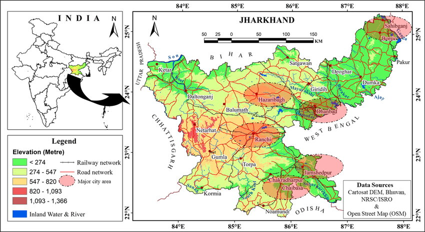
Location and General Relief
Jharkhand lies in eastern India and occupies a transitional position between the Gangetic Plain in the north and the Peninsular Plateau in the south and west. The state is bordered by Bihar in the north, West Bengal in the east, Odisha in the south, Chhattisgarh in the west and Uttar Pradesh along a small north-western boundary.
The state is not a uniform plateau. Its surface is broken into a number of uplands, basins, valleys and hill systems. Elevation generally increases towards the central and western plateau regions, while the northern and eastern margins contain lower surfaces and river valleys.
The major physical characteristics are:
- dominance of plateau relief;
- considerable variation in elevation;
- strong dissection by rivers;
- extensive forested uplands;
- isolated hills and escarpments;
- mineral-rich geological belts.
Extra Information — Jharkhand Is Not a Single Flat Plateau
The term Chotanagpur Plateau can create the impression of one continuous tableland. In reality, Jharkhand contains several plateau levels, structural basins, residual hills and deeply cut river valleys. This varied relief explains the state’s numerous waterfalls and sharp local changes in elevation.
Major Physiographic Divisions
Jharkhand can broadly be divided into several important physiographic regions: the Ranchi Plateau, Hazaribagh Plateau, Pat region, Damodar Valley, Palamu region, Rajmahal Hills and Singhbhum uplands. These regions differ in elevation, rock structure, drainage and natural vegetation.
The central plateau system forms the core of the state, while the Damodar basin cuts across important coal-bearing areas. In the west, the landscape becomes higher and more dissected, while the north-east is marked by the volcanic Rajmahal Hills.
Ranchi Plateau
The Ranchi Plateau forms one of the most important elevated surfaces of Jharkhand. It is broadly undulating and is cut by several rivers that descend sharply along plateau margins.
The plateau is important because:
- it forms the central physical core of Jharkhand;
- several rivers originate or pass through it;
- numerous waterfalls occur along its edges;
- agriculture and settlement are concentrated in suitable valleys;
- Ranchi city developed on this plateau surface.
Famous waterfalls such as Hundru, Dassam and Jonha are closely connected with the dissected relief of the Ranchi Plateau.
Hazaribagh Plateau
The Hazaribagh Plateau lies to the north of the Ranchi Plateau and forms another important upland region. Its landscape consists of rolling plateau surfaces, forested hills and valleys draining mainly towards the Damodar system.
The plateau is also important because it lies close to some of the major mineral and coal-bearing zones of North Chotanagpur. Its physical structure has influenced settlement, mining and transport development.
Pat Region
The Pat region consists of high, flat-topped uplands found mainly in western Jharkhand. These tablelands are especially associated with areas of Latehar, Gumla and Lohardaga.
Their main characteristics are:
- relatively high elevation;
- flat or gently rolling summits;
- steep margins;
- lateritic soils;
- forested surroundings.
The Netarhat Plateau is one of the best-known examples of this highland landscape.
Netarhat Plateau
The Netarhat Plateau is one of the most prominent highland areas of western Jharkhand. It is known for its elevated surface, cooler climate and forested surroundings.
Its importance lies in:
- high elevation;
- pronounced escarpments;
- scenic relief;
- lower temperatures than many surrounding lowlands;
- strong forest cover.
Damodar Valley
The Damodar Valley is one of the most important physical and economic regions of Jharkhand. It is a structural basin that contains major Gondwana coal deposits, making it one of the most industrialised zones of the state.
The valley contains or is closely associated with major coalfields such as:
- Jharia;
- Bokaro;
- Ramgarh;
- North Karanpura;
- South Karanpura.
The Damodar basin demonstrates the close relationship between geological structure and mineral distribution.
Extra Information — Why Coal Is Concentrated in the Damodar Valley
The coalfields of Jharkhand are mainly associated with Gondwana sedimentary basins. These basins developed within structural depressions of the ancient plateau, allowing thick deposits of plant material to accumulate and later transform into coal.
Palamu Region
The Palamu region of western Jharkhand is characterised by dissected plateau surfaces, forests, low hills and river valleys. It is drained mainly by the North Koel River and its tributaries.
The terrain is comparatively rugged and historically made movement and communication difficult. This physical setting also contributed to the strategic importance of Palamu in earlier political history.
Rajmahal Hills
The Rajmahal Hills in north-eastern Jharkhand are geologically distinct from much of the Chotanagpur Plateau. They were formed by ancient volcanic activity and are associated with extensive basaltic lava flows.
The region is important because it contains:
- volcanic rock formations;
- rugged hill landscapes;
- forest cover;
- distinctive drainage patterns.
The volcanic origin of the Rajmahal Hills makes them one of the most unusual geological regions of Jharkhand.
Singhbhum Uplands
The Singhbhum region of southern Jharkhand contains some of the oldest geological formations in India. Its rugged plateau and hill systems are closely associated with rich metallic mineral deposits.
The region is particularly important for:
- iron ore;
- copper;
- uranium;
- manganese and associated minerals.
The ancient rock formations of Singhbhum are therefore central to the mineral geography of Jharkhand.
Major Hills and Peaks
Jharkhand contains several important hills and highland systems. These are generally residual uplands or parts of the dissected plateau structure rather than young fold mountains.
Important hill systems include:
- Parasnath Hills
- Dalma Hills
- Rajmahal Hills
- Netarhat uplands
Parasnath Hill
Parasnath Hill, also known as Shikharji, is the highest and one of the most prominent hills of Jharkhand. It is located in Giridih district and rises sharply above the surrounding plateau.
Its importance is both physical and cultural. Geographically, it forms a conspicuous residual upland; culturally, it is one of the most important Jain pilgrimage centres in India.
Dalma Hills
The Dalma Hills lie near Jamshedpur in East Singhbhum. They form a rugged, forested hill system and are closely associated with the Dalma Wildlife Sanctuary.
The hills are important for:
- forest ecology;
- wildlife movement;
- elephant habitats;
- regional relief.
Geological Structure of Jharkhand
Jharkhand has one of the oldest geological foundations in India. Much of the state consists of Precambrian crystalline rocks, including granite, gneiss, schist and quartzite.
The principal geological formations include:
- ancient crystalline rocks of the Chotanagpur Plateau;
- Singhbhum iron-bearing formations;
- Gondwana sedimentary basins;
- Rajmahal volcanic rocks;
- lateritic surface deposits.
This geological diversity is the main reason for Jharkhand’s exceptional mineral wealth.
Extra Information — Geology Explains the Economy
Jharkhand’s industrial importance is rooted directly in its physical geography. Coal in the Damodar basin, iron ore in Singhbhum, bauxite on lateritic uplands and copper in ancient mineral belts are all products of different geological formations.
Gondwana Basins and Coal
The Gondwana rock system is particularly important in Jharkhand because it contains the major coalfields of the state. These sedimentary rocks developed in ancient structural basins, especially along the Damodar Valley.
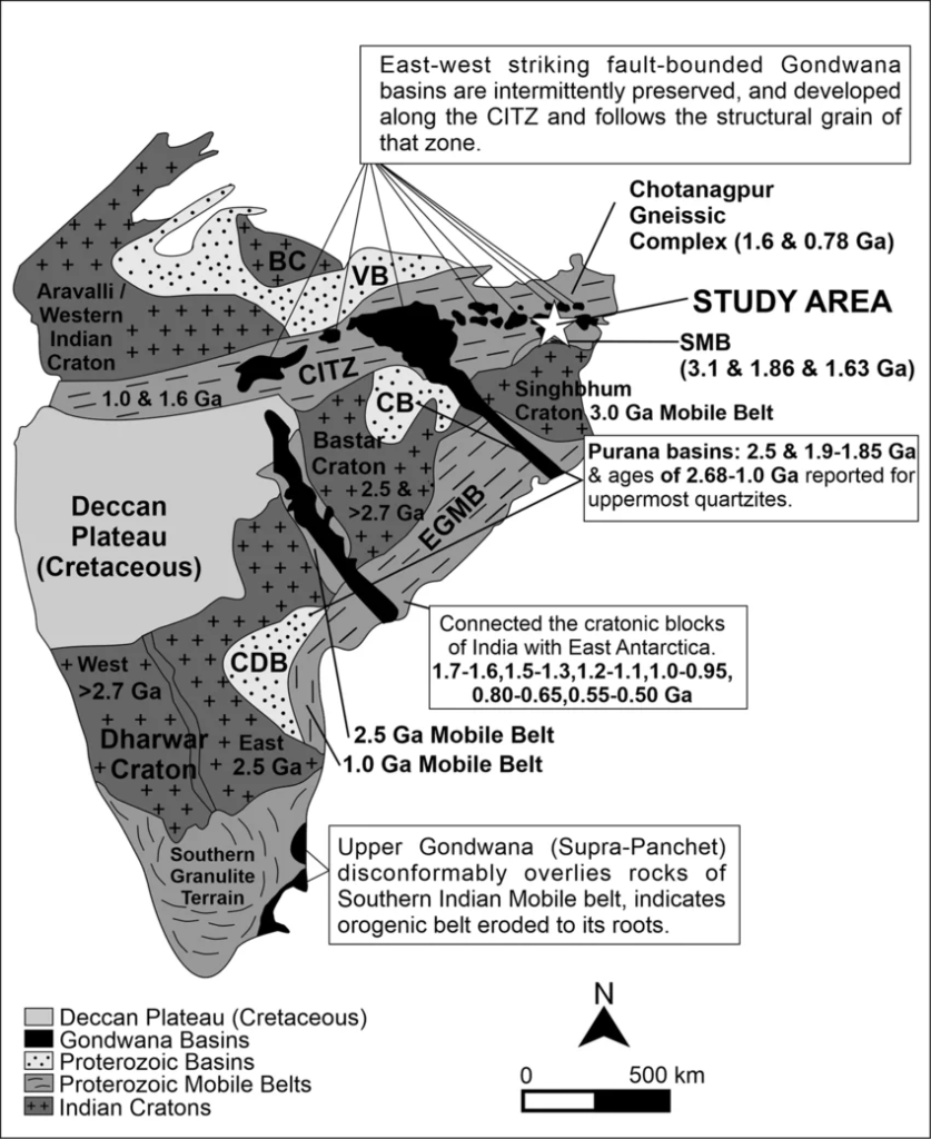
Major coalfields include:
- Jharia
- Bokaro
- North Karanpura
- South Karanpura
- Ramgarh
These coalfields later became the foundation for major mining and industrial centres.
Drainage System of Jharkhand
Jharkhand’s rivers generally originate on plateau surfaces and flow outward towards the surrounding plains. Because the plateau is highly dissected, river gradients are often steep, particularly near plateau edges.
The major river systems include:
- Damodar
- Subarnarekha
- North Koel
- South Koel
- Sankh
- Barakar
- Ajay
- Mayurakshi
Damodar River
The Damodar is one of the most important rivers of Jharkhand. It drains a large part of central and northern Jharkhand and flows eastward into West Bengal.
Its important tributaries include:
- Barakar;
- Konar;
- Bokaro.
The river is closely associated with the coal and industrial belt of the state.
Barakar River
The Barakar is one of the most important tributaries of the Damodar. It drains parts of northern Jharkhand and plays an important role in the river system of the Damodar basin.
Subarnarekha River
The Subarnarekha originates in the Ranchi plateau region and flows eastward through Jharkhand before entering West Bengal and Odisha.
It is important because it:
- drains the Ranchi and Singhbhum regions;
- supports agriculture and settlements;
- passes through major industrial areas;
- forms several waterfalls in its upper course.
North Koel River
The North Koel is the principal river of the Palamu region. It drains western Jharkhand and ultimately becomes part of the Son river system.
South Koel and Sankh Rivers
The South Koel and Sankh drain western and southern Jharkhand. Their waters ultimately combine to form part of the Brahmani river system.
These rivers are especially important for the drainage of Gumla, Simdega and adjoining areas.
Waterfalls of Jharkhand
Jharkhand is famous for waterfalls because many rivers descend sharply from plateau surfaces. Resistant crystalline rocks and sudden breaks in slope create ideal conditions for waterfall formation.
Important waterfalls include:
| Waterfall | Associated River/Region |
|---|---|
| Hundru Falls | Subarnarekha |
| Dassam Falls | Kanchi River |
| Jonha Falls | Ranchi Plateau region |
| Hirni Falls | Western plateau region |
| Lodh Falls | Latehar region |
The large number of waterfalls is therefore a direct result of the dissected plateau relief.
Climate of Jharkhand
Jharkhand has a tropical monsoon climate, but elevation creates substantial local variation. Plateau areas such as Ranchi and Netarhat experience more moderate temperatures than lower valleys and northern districts.
The climate can broadly be divided into:
- hot summer;
- south-west monsoon season;
- cool and dry winter.
Most annual rainfall is received between June and September from the south-west monsoon.
Summer
Summers are generally hot, especially in lower valleys and northern parts of the state. Plateau elevation moderates temperatures in places such as Ranchi and Netarhat.
Monsoon
The south-west monsoon provides the majority of annual rainfall. Relief causes regional variation, with some upland and eastern areas receiving more rainfall than relatively drier western interiors.
Winter
Winters are generally dry and cool. Night temperatures can fall considerably in elevated plateau areas because of altitude and continental conditions.
Soils of Jharkhand
The soils of Jharkhand are mainly derived from the weathering of ancient crystalline rocks. Their characteristics vary according to relief, rock type and rainfall.
The major soil types are:
- red soil
- lateritic soil
- sandy soil
- alluvial soil in river valleys
Red Soil
Red soils are widespread over the plateau and derive their colour from iron oxides. They are generally low in humus and may require irrigation and fertilisers for intensive agriculture.
Lateritic Soil
Lateritic soils occur particularly on high and heavily weathered plateau surfaces. They are associated with prolonged leaching under tropical climatic conditions.
They are usually:
- rich in iron and aluminium;
- poor in organic matter;
- relatively low in fertility.
Alluvial Soil
Alluvial soils occur in river valleys and some northern lowlands. These soils are generally more fertile than upland red and lateritic soils.
Natural Vegetation
Jharkhand’s natural vegetation is mainly tropical deciduous forest. The most characteristic tree is Sal, which dominates large forest tracts.
Other common vegetation includes:
- bamboo;
- mahua;
- kendu;
- palash;
- mixed deciduous species.
Forest cover is particularly important in western and southern districts.
Sal Forests
Sal forests are one of the defining ecological features of Jharkhand.
They are important because they provide:
- timber;
- leaves;
- fuel;
- forest-based livelihoods;
- wildlife habitat.
The distribution of Sal is closely related to the plateau climate and soils.
Major Forest Regions
Important forest belts occur in:
- West Singhbhum;
- Latehar;
- Gumla;
- Simdega;
- parts of Ranchi and Khunti;
- Dalma region.
Forests are generally denser in rugged areas where agricultural expansion has been more limited.
Wildlife and Physical Environment
The forested plateau provides habitat for a wide range of wildlife.
Important species include:
- elephants;
- deer;
- wild boar;
- sloth bear;
- leopard;
- numerous birds and reptiles.
The Singhbhum-Dalma belt is particularly important for elephant movement.
Mineral Geography of Jharkhand
Jharkhand’s mineral wealth is directly connected with its geological history. Different minerals occur in distinct geological belts rather than being evenly distributed across the state.
The major mineral resources include:
- coal;
- iron ore;
- copper;
- bauxite;
- uranium;
- mica;
- limestone.
Coal
Coal is concentrated mainly in the Gondwana basins of the Damodar Valley.
The major coalfields are:
- Jharia;
- Bokaro;
- Karanpura;
- Ramgarh.
Iron Ore
Iron ore is concentrated especially in the Singhbhum belt, one of India’s most important iron-bearing regions.
Copper
Copper deposits occur particularly in the Singhbhum Copper Belt.
Bauxite
Bauxite occurs mainly on lateritic uplands of western Jharkhand, especially where prolonged weathering has concentrated aluminium-rich material.
Uranium
Important uranium-bearing formations occur in the Singhbhum region.
Extra Information — Mineral Distribution Follows Rock Structure
Jharkhand’s minerals are not randomly scattered. Coal belongs mainly to Gondwana sedimentary basins, iron and copper to ancient Singhbhum formations, and bauxite to deeply weathered lateritic uplands.
Relief and Agriculture
The plateau terrain strongly influences agriculture. Large areas are unsuitable for intensive cultivation because of shallow soils, uneven relief and dependence on seasonal rainfall.
Agriculture is therefore concentrated especially in:
- valleys;
- lower plateau surfaces;
- river basins;
- better-watered depressions.
Rice is the dominant crop in suitable lowlands, while uplands support a wider variety of crops.
Relief and Settlement Pattern
Population distribution also reflects physical geography. Settlements are generally denser in agricultural valleys, mining belts and transport corridors, while rugged forested uplands historically supported lower population densities.
This has produced a strong contrast between:
- plateau interiors;
- mineral-industrial belts;
- river valleys;
- forested hills.
Physical Geography and Industrial Development
Jharkhand’s major industrial centres developed where mineral resources, water and transport came together.
Important examples include:
- Jamshedpur, associated with nearby iron ore and mineral resources;
- Dhanbad, associated with the Jharia coalfield;
- Bokaro, associated with coal and steel;
- Ramgarh, associated with coalfields and industrial activity.
The state’s industrial geography is therefore a direct outcome of its physical geography.
Major Physiographic Regions at a Glance
| Region | Main Physical Features |
|---|---|
| Ranchi Plateau | Elevated plateau, dissected rivers and waterfalls |
| Hazaribagh Plateau | Rolling upland and forested terrain |
| Pat Region | High flat-topped plateaus |
| Damodar Valley | Structural basin and major coalfields |
| Palamu Region | Dissected plateau, forests and river valleys |
| Rajmahal Hills | Volcanic hill system |
| Singhbhum Region | Ancient rocks and metallic mineral belts |
| Dalma Hills | Forested hill range and wildlife habitat |
Major Rivers at a Glance
| River | Physical Importance |
|---|---|
| Damodar | Major drainage and industrial valley |
| Barakar | Important tributary of Damodar |
| Subarnarekha | Drains Ranchi and Singhbhum |
| North Koel | Major river of Palamu |
| South Koel | Drains western and southern plateau |
| Sankh | Important south-western drainage |
| Ajay | Drains north-eastern areas |
| Mayurakshi | Important north-eastern river |
Major Minerals and Their Regions
| Mineral | Major Region |
|---|---|
| Coal | Damodar Valley |
| Iron Ore | Singhbhum |
| Copper | Singhbhum Copper Belt |
| Bauxite | Western lateritic highlands |
| Uranium | Singhbhum region |
| Mica | Northern Jharkhand belt |
Physical Geography of Jharkhand: Key Characteristics
Jharkhand’s physical geography can be understood through a few major features:
- dominance of the Chotanagpur Plateau;
- ancient crystalline geology;
- multiple plateau levels and dissected relief;
- numerous waterfalls;
- major river systems flowing outward from uplands;
- extensive tropical deciduous forests;
- widespread red and lateritic soils;
- exceptional mineral wealth;
- strong relationship between geology and industrial development.
The state’s physical landscape is therefore not merely a background to its history and economy. It is the fundamental factor that has shaped settlement, agriculture, forests, mining, industry and regional development.
Frequently Asked Questions (FAQs)
1. Which plateau dominates the physical geography of Jharkhand?
The Chotanagpur Plateau dominates most of the state.
2. Is Jharkhand a plain or plateau state?
Jharkhand is predominantly a plateau state, although river valleys and lower plains occur in several regions.
3. What are the major physiographic divisions of Jharkhand?
The major divisions include the Ranchi Plateau, Hazaribagh Plateau, Pat region, Damodar Valley, Palamu region, Rajmahal Hills and Singhbhum uplands.
4. What is the Pat region?
The Pat region consists of high, flat-topped plateau surfaces, especially in western Jharkhand.
5. Which is the best-known highland of western Jharkhand?
The Netarhat Plateau is one of the best-known highland areas.
6. Which is the highest hill of Jharkhand?
Parasnath Hill or Shikharji is the highest and one of the most prominent hills of the state.
7. Why does Jharkhand have so many waterfalls?
The waterfalls occur because rivers descend sharply from elevated and dissected plateau surfaces.
8. Which river forms Hundru Falls?
Hundru Falls is formed by the Subarnarekha River.
9. Which river forms Dassam Falls?
Dassam Falls is associated with the Kanchi River.
10. What is special about the Rajmahal Hills?
The Rajmahal Hills are of volcanic origin and are associated with ancient basaltic lava flows.
11. Which are the major rivers of Jharkhand?
The major rivers include the Damodar, Subarnarekha, North Koel, South Koel, Sankh and Barakar.
12. Which river is most closely associated with the coal belt?
The Damodar River and its basin are most closely associated with Jharkhand’s major coalfields.
13. Why is the Damodar Valley economically important?
It contains major coalfields and has developed into one of the state’s most important industrial regions.
14. Which are the major coalfields of Jharkhand?
Important coalfields include Jharia, Bokaro, North Karanpura, South Karanpura and Ramgarh.
15. Which region is famous for iron ore?
The Singhbhum region is particularly important for iron ore.
16. Where is copper mainly found in Jharkhand?
Copper is concentrated mainly in the Singhbhum Copper Belt.
17. Where is bauxite mainly found?
Bauxite occurs especially on the lateritic highlands of western Jharkhand.
18. What are the main soils of Jharkhand?
The major soils are red, lateritic, sandy and alluvial soils.
19. Why are many Jharkhand soils red?
The red colour is mainly due to the presence of iron oxides.
20. What type of climate does Jharkhand have?
Jharkhand has a tropical monsoon climate with hot summers, a rainy monsoon season and cool dry winters.
21. What is the dominant natural vegetation of Jharkhand?
The dominant natural vegetation is tropical deciduous forest, particularly Sal forest.
22. Why is Sal important in Jharkhand?
Sal is a dominant forest tree and provides timber, leaves, fuel and wildlife habitat.
23. Which areas have major forest cover?
Large forest belts occur in West Singhbhum, Latehar, Gumla, Simdega and parts of Ranchi and Khunti.
24. Why is Jharkhand rich in minerals?
Its mineral wealth is the result of its ancient and geologically diverse rock formations, including Gondwana basins and the Singhbhum mineral belts.





