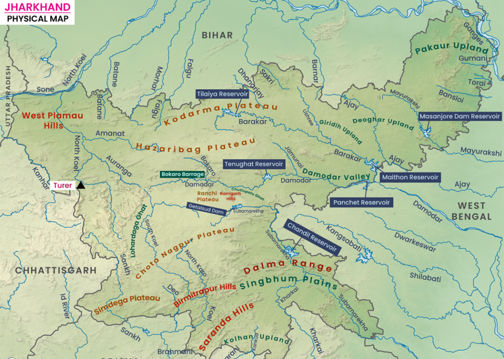
Introduction to Jharkhand's Drainage System
The drainage system of Jharkhand holds great geographical significance.
The rivers of Jharkhand can be classified into two major categories:
(1) Southern Drainage System (rivers flowing into the Bay of Bengal)
(2) Northern Drainage System (rivers flowing northwards and merging into the Ganga)
The Subarnarekha, Shankh, and South Koel rivers fall under the first category, while the Damodar and North Koel rivers belong to the second category.
The watershed dividing these two systems runs roughly in an east-west direction across the Chotanagpur Plateau.

Get Jharkhand Special Full Course for Prelims and Mains
Click here For 14th JPSC Foundation batch
In the Chotanagpur Plateau region, several rivers flow through distinct routes, such as:
- Damodar River and its tributaries (flowing through Hazaribagh and Ranchi)
- North Koel River (in the northwestern part of the plateau)
- South Koel River (in the southwestern part)
- Subarnarekha River (in the southeastern part)
Major River Basins of Jharkhand
1. Damodar River Basin
- Flow Direction: West to east.
- Geographical Stretch: Between Ranchi Plateau and Hazaribagh Plateau.
- Nature: It occupies a faulted trough — a sunken section formed due to tectonic activity.
- Major Tributaries:
- Barakar River (forms a nearly independent valley),
- Konar River,
- Gobai River.
The Damodar Basin covers a large portion of the Chotanagpur Plateau and is heavily industrialized and coal-rich.
2. North-Eastern Drainage Basin
- Location: Northern and eastern part of the Chotanagpur Plateau.
- Major Rivers:
- Ajay River,
- Mor (Mayurakshi) River,
- Brahmani River,
- Gumani River.
- Course: These rivers originate from Jharkhand and flow eastwards or north-eastwards to merge into the Ganga River.
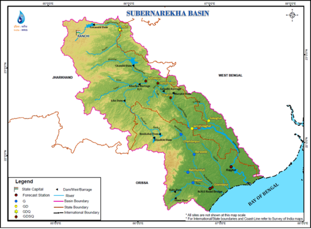
3. Subarnarekha River Basin
- Origin: Near Nagdi village, close to Ranchi city, in the Ranchi Plateau.
- Flow Direction: Southeast towards the Bay of Bengal.
- Major Tributary:
- Kharkai River (joins near Jamshedpur).
The Subarnarekha River is significant because it is one of the few rivers from Jharkhand that flows directly into the Bay of Bengal without merging into any larger river like the Ganga.
4. South Koel River Basin
- Origin: Southwestern part of the Ranchi Plateau.
- Flow Direction: Southwestwards.
- Major Tributary:
- Shankh River.
The South Koel and Shankh Rivers eventually combine and later merge into the Brahmani River system in Odisha.
5. Sone and North Koel River Basin
- North Koel River:
- Originates from the western part of the Ranchi Plateau.
- Flows through Palamu district.
- Major tributaries include Amanat, Auranga, Gohda, and Maila rivers.
- Finally merges into the Sone River, a tributary of the Ganga.
The North Koel and Sone river system is crucial for northern Jharkhand, providing irrigation and supporting biodiversity.
Important Rivers of Jharkhand
Jharkhand's rivers can be categorized based on their flow direction:
(A) Northward Flowing Rivers
| River Name | Origin and Description |
|---|---|
| Sone | Originates from Amarkantak Hills (Madhya Pradesh); North Koel is its important tributary. |
| North Koel | Originates from Ranchi Plateau, flows through Palamu and joins Sone. |
| Punpun | Flows northward from North Koel basin. |
| Fulgu | Originates from the Chotanagpur plateau; merges into Ganga near Tal area. |
| Sakri | Emerges from northern Chotanagpur Plateau. |
| Chanan (Panchane) | Formed by joining of five streams: Pemar, Tilaiya, Dhanari, Mahane, and Panchane. |
(B) Eastward/Southward Flowing Rivers
| River Name | Origin and Description |
|---|---|
| Damodar | Known as "Sorrow of Bengal" due to devastating floods; now tamed by the Damodar Valley Corporation projects. |
| Subarnarekha | Originates near Ranchi; flows directly into Bay of Bengal; rich in gold particles in river sand. |
| Barakar | Major tributary of Damodar River. |
| South Koel | Rises near Nagdi village, merges with Shankh River. |
| Shankh | Originates from Gumla district and joins South Koel. |
| Ajay | Flows through Deoghar and Dumka into Bhagirathi River in West Bengal. |
| Mor (Mayurakshi) | Originates from Deoghar area and merges into Ganga. |
| Brahmani | Rises from Dudhwa Hills of Dumka district. |
| Gumani | Flows from Rajmahal Hills into the Ganga. |
| Bansloi | Originates from Bans Hills in Godda district; merges into Ganga. |
Complete List of Waterfalls of Jharkhand
| No. | Waterfall Name | Location | Special Feature |
|---|---|---|---|
| 1 | Hundru Falls | Near Ranchi on Subarnarekha River | Height: 74 meters |
| 2 | Dassam Falls | On Ranchi-Tata Road; on Kanchi River | Height: 40 meters |
| 3 | Jonha Falls (Gautamdhara) | Near Ranchi on Raru River | Height: 17 meters |
| 4 | Lodh/Buddha Ghagh Falls | Latehar district on North Koel River | Highest waterfall of Jharkhand (137 meters) |
| 5 | Hirni Falls | 40 km north of Chakradharpur | Scenic beauty |
| 6 | Sadni Falls | On Shankh River, Gumla district | Height: 60 meters |
| 7 | Rajrappa Falls | Confluence of Damodar and Bhairavi rivers | Pilgrimage and religious significance |
| 8 | Kelaghagh Falls | In Simdega district | — |
| 9 | Gautamghagh Falls | Near Mahuadand area | Height: approx. 36 meters |
| 10 | Ghaghri Falls | In Netarhat Plateau | Height: 43 meters |
| 11 | Sukhaldari Falls | South of Nagenia | Height: 30 meters |
| 12 | Panchdhara Falls | 14 km from Khunti | Formed by five streams |
| 13 | Tamasir Falls | In Chatra district | — |
| 14 | Thakora Falls | Manjhari block, West Singhbhum | Near Vidri village |
| 15 | Surkakata Ghagh Falls | In Simdega district | Near Hardibeda village |
| 16 | Sunua Falls | In Angara block, Ranchi district | 12 km from Angara |
| 17 | Serka Falls | Bishunpur block, Gumla district | 1 km from Bishunpur |
| 18 | Dharaghari Falls | 18 km from Ghatsila | — |
| 19 | Motijhara Falls | Rajmahal Hills, near Maharajpur station | Height: 46 meters |
| 20 | Gurghajh Falls | In Garhwa district | — |
| 21 | Ragova Falls | 6 km from Chatra | — |
| 22 | Gautamghagh Falls | 10 km southeast of Mahuadand | Height: 36 meters |
| 23 | Ghargharia Falls | At the foothills of Pat region, Lohardaga district | — |
| 24 | Ghaghri Falls | 7 km north of Netarhat | Height: 43 meters |
| 25 | Jonha/Gautamdhara Falls | 32 km southeast of Ranchi on Raru River | Height: 17 meters |
| 26 | Tamasir Falls | 26 km from Chatra | — |
| 27 | Thakora Falls | Manjhari block, Singhbhum district | — |
| 28 | Rajrappa Falls | 25 km east of Ramgarh | Confluence of Damodar and Bhairavi Rivers |
| 29 | Lupungutu Falls | 2 km from Chaibasa | — |
| 30 | Sadni Ghagh Falls | On Shankh River, Gumla district | Height: 60 meters |
| 31 | Sukhaldari Falls | 35 km south of Nagri Tandi | Height: 30 meters |
| 32 | Surkakata Falls | 23 km from Simdega | — |
| 33 | Sunua Falls | Angara block, Ranchi district | — |
| 34 | Serka Falls | Near Bishunpur, Gumla district | — |
| 35 | Hirni Falls | Near Chakradharpur | Scenic beauty |
| 36 | Hundru Falls | Near Ranchi on Subarnarekha River | Height: 74 meters |
| 37 | Hesatu Falls | In Garhwa district | — |
| 38 | Dassam Falls | Ranchi to Tata road; on Kanchi River | Height: 40 meters |
| 39 | Dharaghari Falls | Near Ghatsila | — |
| 40 | Nargpheni Falls | 14 km from Gumla | — |
| 41 | Premaghagh Falls | In Raidih block, Gumla district | — |
| 42 | Pairnaghagh Falls | 15 km from Tapkara | — |
| 43 | Balchaura Falls | In Ghureki block, Garhwa district | Situated on Kanhar River |
| 44 | Motijhara Falls | Rajmahal Hills, near Maharajpur Station | Height: 46 meters |
| 45 | Maludah Falls | In Chatra district | — |
| 46 | Mirchaiya Falls | In Garu block, Latehar district | — |
| 47 | Munidih Falls (Bhathinda area) | Located in Dhanbad district | — |
Hot Springs (Thermal Springs) of Jharkhand
Jharkhand has several thermal hot springs arising due to underground geothermal activities. These hot springs are considered not just natural wonders but also have religious significance.
Some of the major hot springs are:
| Hot Spring | Location | Special Note |
|---|---|---|
| Surajkund | Hazaribagh | Hottest spring in India (Temperature: ~88°C) |
| Tatapani | Latehar | Popular pilgrimage spot |
| Charak Khurd | Near Dhanbad-Giridih Road | — |
| Tattloi | Near Dumka | Located on the banks of Jharjhari River |
| Tapta Pani | Dumka | Near Kumrabad on the banks of Mor River |
| Nunsbil | Dumka | Near Nalagutia area |
| Barajharna | Dumka | — |
| Bara Masia | Pakur district | — |
| Shivpur Sota | Pakur | — |
Notes for JPSC Exam
Related Articles
The Chhotanagpur Unnati Samaj: Pioneering Tribal Empowerment and Cultural Revival
Chief Minister of Jharkhand: Champai Soren Assumes Leadership (February 2024)
Tasar Silk: Jharkhand’s Pride at the Republic Day Parade 2024
Balaji Temple in Jharkhand: A New Spiritual Landmark
Jharkhand Economic Growth 2024: Notes For JPSC Exam (PDF Download)
Jharkhand Economy : A Comprehensive Overview for JPSC Exam (PDF Download)
Regional Dynasties of Jharkhand- A Comprehensive Overview
Ancient Period in Jharkhand: A Must Read for JPSC 2025 (PDF Available)
Religious Movements in Jharkhand
Prehistoric period in Jharkhand
Jharkhand History: A Must-Have Guide for JPSC CCE Exam 2025 (PDF Available)
General Introduction of Jharkhand 2024: A must read guide for JPSC Exam (PDF Available)
Shifting Cultivation (Jhum Cultivation): A Traditional farming of Jharkhand
Practice Questions for UPSC
Prelims Practice Questions
- 1. The Subarnarekha River is part of the Northern Drainage System.
- 2. The Damodar River is known for its industrial significance.
- 3. All rivers in Jharkhand eventually merge into the Ganga.
Which of the above statements is/are correct?
- 1. South Koel River
- 2. Damodar River
- 3. Shankh River
Select the correct answer using the codes given below.
Frequently Asked Questions
What are the two major drainage systems of Jharkhand, and how do they differ?
The two major drainage systems of Jharkhand are the Southern Drainage System, which includes rivers flowing into the Bay of Bengal, and the Northern Drainage System, which comprises rivers flowing northward into the Ganga. The Southern system is characterized by rivers like the Subarnarekha and South Koel, while the Northern system includes rivers such as the Damodar and North Koel.
How does the watershed in Jharkhand affect its drainage systems?
The watershed dividing the Southern and Northern Drainage Systems runs in an east-west direction across the Chotanagpur Plateau. This geographical feature significantly influences the flow direction of the rivers, determining whether they will join the Bay of Bengal or merge into the Ganga.
What is the significance of the Damodar River Basin in Jharkhand?
The Damodar River Basin is significant as it is heavily industrialized and contains rich coal deposits, making it a crucial area for energy production in Jharkhand. It also acts as a water resource for irrigation and supports various ecosystems within its valley.
What are the key rivers that flow to the north and east from Jharkhand, and what is their course?
Key rivers flowing north and east from Jharkhand include the Ajay, Mor (Mayurakshi), Brahmani, and Gumani rivers. These rivers originate in Jharkhand and generally flow towards the Ganga, playing an essential role in connecting Jharkhand's watershed with the larger river system.
Why is the Subarnarekha River considered significant among Jharkhand's rivers?
The Subarnarekha River is significant because it directly flows into the Bay of Bengal without merging into any larger river like the Ganga. Additionally, it is known for being rich in gold particles found in its river sand, adding both ecological and economic importance to the region.
Source: LearnPro Editorial | Geography | Published: 6 October 2025 | Last updated: 10 March 2026
About LearnPro Editorial Standards
LearnPro editorial content is researched and reviewed by subject matter experts with backgrounds in civil services preparation. Our articles draw from official government sources, NCERT textbooks, standard reference materials, and reputed publications including The Hindu, Indian Express, and PIB.
Content is regularly updated to reflect the latest syllabus changes, exam patterns, and current developments. For corrections or feedback, contact us at admin@learnpro.in.