
Tags: GS Paper 1 – Physical Geography: Climatic Regions of India; GS Paper 3 – Climate Change, Agriculture
For Prelims: Köppen-Geiger climate classification, BShw, Aw, tropical savanna, hot semi-arid, IMD, IITM Pune, MAUSAM journal, rain shadow
For Mains: Changing climate zones and their impact on cropping patterns, water management and drought policy
Why in News?
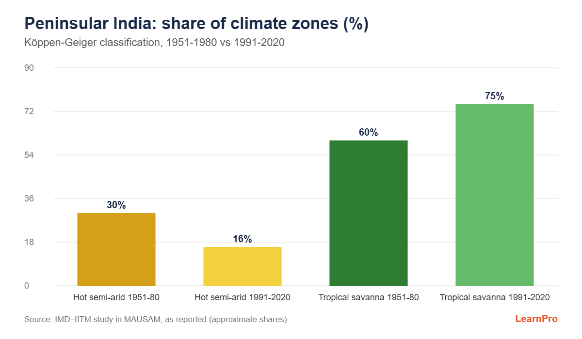
A study by scientists of the India Meteorological Department (IMD) and the Indian Institute of Tropical Meteorology (IITM), Pune, published in IMD’s journal MAUSAM, finds that southern India has become wetter over seven decades. The area under a hot semi-arid climate fell from about 30% to 16% of the peninsula between 1951-1980 and 1991-2020.
Key Findings
- Much of the hot semi-arid region has changed into a tropical savanna climate, which gets more rain but still has a long dry season.
- Tropical savanna now covers nearly three-fourths of peninsular India, up from about three-fifths in the 1950s.
- The study used IMD rainfall and temperature records from 1951 to 2020 and compared successive 30-year periods by meteorological subdivision.
- The researchers flagged possible effects on agriculture.
What is the Köppen Climate Classification?
- Developed by Wladimir Köppen (1884, later revised with Rudolf Geiger). It classifies climate by temperature and precipitation and their seasonal patterns, which closely track natural vegetation.
- Five main groups: A (tropical), B (dry), C (temperate), D (continental) and E (polar), with sub-types such as w (dry winter), s (dry summer) and f (no dry season).
| Köppen type | Description | Regions in India |
|---|---|---|
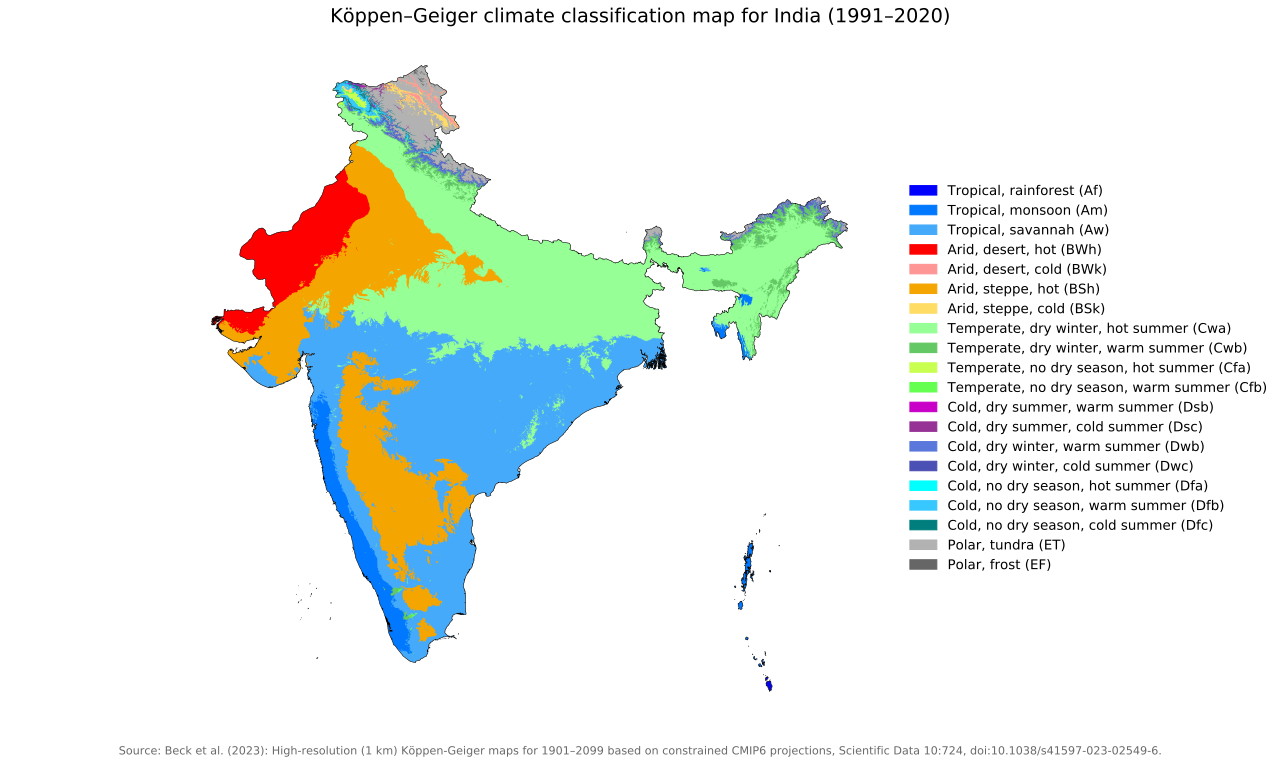
| Amw | Monsoon type with a short dry season | West coast south of Goa |
| Aw | Tropical savanna | Most of the peninsular plateau |
| BShw | Hot semi-arid steppe | Rain-shadow areas of Karnataka, Telangana, Rajasthan and Gujarat |
| BWhw | Hot desert | Western Rajasthan |
| Cwg | Monsoon type with dry winter | Ganga plains |
| Dfc / E | Cold humid winter / polar type | Arunachal Pradesh; higher Himalaya and Ladakh |
Possible Reasons for the Shift
- A rise in heavy and extreme rainfall events linked to warming, since a warmer atmosphere holds more moisture.
- Changes in the northeast monsoon and in cyclone activity over the Bay of Bengal.
- Natural variability over several decades, such as the Pacific Decadal Oscillation and the Indian Ocean Dipole.
Implications
- Agriculture: Cropping patterns and suitability may change. Drought-hardy crops such as millets may give way to more water-intensive crops.
- Drought policy: District drought classifications and crop insurance benchmarks based on old climate ‘normals’ may need revision.
- Water: Wetter years bring opportunities for groundwater recharge, but also more urban flooding (for example, Chennai and Bengaluru).
- Ecology: The ranges of dry deciduous forests and grassland species may shift.
Conclusion
Climate zones are changing over decades, not only in the long-term future. Planning for agriculture, water and disasters in peninsular India should be based on updated climate normals and local data.
Frequently Asked Questions (FAQs)
1. Which climate type covers most of peninsular India now?
Tropical savanna (Aw).
2. What does ‘w’ mean in Köppen symbols?
A dry winter season.
3. Where is IITM located?
Pune.
Practice Question
Mains: Changing climate zones in India have implications beyond meteorology. Discuss with reference to recent findings on peninsular India. (150 words)
Sources and further reading
- Beck, H.E., McVicar, T.R., Vergopolan, N., Alexis, B., Lutskcommons.wikimedia.org