
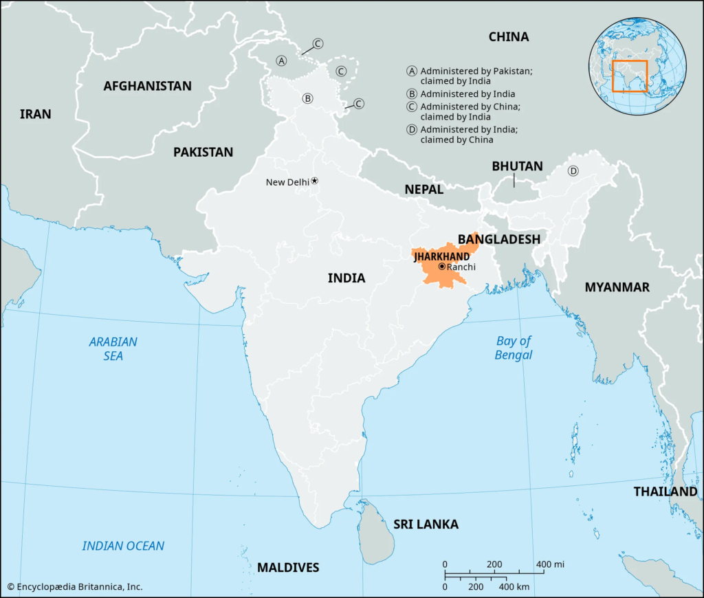
Location of Jharkhand : Jharkhand is a landlocked state of eastern India situated mainly on the Chotanagpur Plateau. It occupies a geographical area of about 79,714 km² and lies between the Gangetic Plain in the north and the Peninsular Plateau towards the south and west. Its position gives the state considerable geographical diversity, ranging from lower northern margins adjoining Bihar to high plateau surfaces, forested hills and mineral-bearing uplands in the central, western and southern regions.
Jharkhand shares its boundaries with five Indian states—Bihar, West Bengal, Odisha, Chhattisgarh and Uttar Pradesh. The state was formed on 15 November 2000 after the southern districts of Bihar were reorganised into a separate state. Its location at the meeting point of eastern, northern and central India has influenced transport, migration, trade, tribal distribution, industrial development and regional culture.
For the complete collection of state-specific study material, see JPSC Notes.
Jharkhand: Basic Location Data
| Geographical Feature | Details |
|---|---|
| Region of India | Eastern India |
| Geographical Area | 79,714 km² |
| Latitude | Approximately 21°58′ N to 25°18′ N |
| Longitude | Approximately 83°22′ E to 87°57′ E |
| Capital | Ranchi |
| Number of Districts | 24 |
| States Sharing Boundary | 5 |
| Northern Boundary | Bihar |
| Eastern Boundary | West Bengal |
| Southern Boundary | Odisha |
| Western Boundary | Chhattisgarh |
| North-Western Boundary | Uttar Pradesh |
| Dominant Physical Region | Chotanagpur Plateau |
| Coastline | None – landlocked state |
These coordinates place Jharkhand completely within the Northern and Eastern Hemispheres and within the tropical-subtropical transition of the Indian subcontinent.

Latitudinal Extent of Jharkhand
Jharkhand extends approximately from 21°58′ North to 25°18′ North latitude. This north-south extent places the state within the tropical belt, although elevation modifies temperature considerably in plateau areas such as Ranchi and Netarhat.
Latitude affects the state’s:
- solar radiation;
- temperature regime;
- seasonal variation;
- monsoon circulation.
However, altitude is equally important. Ranchi is considerably cooler than many lower northern and western valleys despite lying within roughly the same broad tropical latitude.
Longitudinal Extent
Jharkhand extends approximately from 83°22′ East to 87°57′ East longitude. Its east-west spread connects the western plateau bordering Chhattisgarh and Uttar Pradesh with the lower and more humid eastern region adjoining West Bengal.
This longitudinal extent is reflected in several geographical contrasts. Western Jharkhand contains large forested and relatively drought-prone plateau regions, whereas eastern Jharkhand is more strongly connected with the Bengal economic and transport corridor.
Tropic of Cancer and Jharkhand
The Tropic of Cancer, located at approximately 23½° North latitude, passes through Jharkhand. This gives the state an important geographical position within India’s tropical zone.
However, the climate of Jharkhand cannot be explained by latitude alone. Elevation strongly modifies local conditions, particularly over the Ranchi Plateau, Netarhat highlands and other elevated surfaces. Consequently, several parts of Jharkhand experience comparatively mild temperatures despite their tropical latitude.
The passage of the Tropic of Cancer is important because it places Jharkhand among the Indian states crossed by this major geographical latitude.
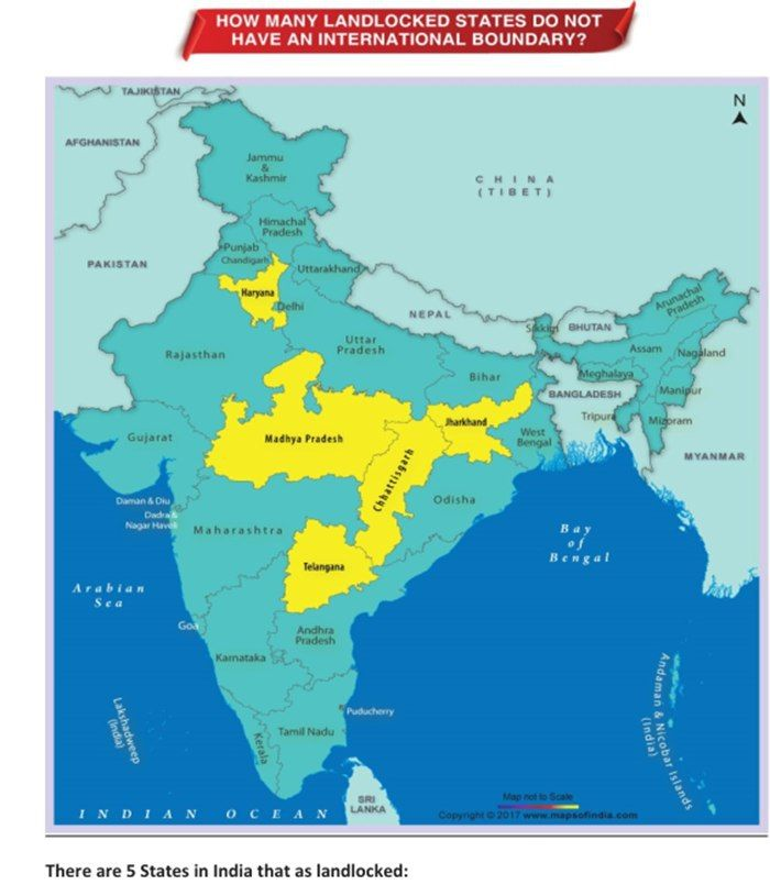
Jharkhand as a Landlocked State
Jharkhand has no coastline and no direct access to the sea. All movement of goods to major ports therefore depends on road and railway connections through neighbouring states, especially West Bengal and Odisha.
This landlocked position has not prevented Jharkhand from becoming an important industrial state because it possesses major inland mineral resources. Coal, iron ore and other minerals encouraged the development of extensive railway networks connecting the state with Kolkata, Haldia and other eastern transport corridors.
The combination of mineral wealth + central plateau location + railway connectivity has therefore compensated to some extent for the absence of direct maritime access.
Jharkhand and Bihar
Bihar forms the entire northern boundary of Jharkhand and historically has the strongest administrative connection with the state. Before 15 November 2000, the territory of present-day Jharkhand formed the southern part of Bihar.
The physical geography changes noticeably near this boundary. Jharkhand’s plateau gradually descends towards the Gangetic Plain, while northern districts such as Koderma, Giridih, Deoghar, Godda and Sahibganj create transitional zones between plateau and plain landscapes.
The Jharkhand-Bihar boundary is therefore important not only politically but also physiographically.
Important Northern Border Districts
Districts lying along or close to the Bihar boundary include:
- Garhwa;
- Palamu;
- Chatra;
- Koderma;
- Giridih;
- Deoghar;
- Godda;
- Sahibganj.
The precise boundary follows administrative limits rather than a single natural geographical feature.
Jharkhand and West Bengal
West Bengal lies to the east of Jharkhand and shares an extensive boundary with the state. This boundary connects Jharkhand’s plateau and mineral-industrial region with the Bengal plains and major urban-industrial markets.
Important geographical connections include:
- Damodar Valley;
- Subarnarekha basin;
- railway corridors;
- coal and industrial transport;
- historical links with Manbhum and Jungle Mahal.
Eastern Jharkhand gradually transitions towards lower elevations in several places, although the Rajmahal Hills and eastern plateau extensions interrupt this pattern.
Eastern Border Districts
Important districts adjoining or lying close to West Bengal include:
- Sahibganj;
- Pakur;
- Dumka;
- Jamtara;
- Dhanbad;
- Bokaro;
- East Singhbhum.
The Jharkhand-West Bengal boundary is particularly significant economically because mineral and industrial goods move extensively across it.
Jharkhand and Odisha
Odisha forms much of the southern boundary of Jharkhand. The boundary runs through a region dominated by forests, hills, river valleys and mineral-rich geological formations.
The southern border is geographically important because both Jharkhand and northern Odisha form part of one of India’s most mineral-rich belts. The Singhbhum-Keonjhar region is especially important for iron ore and associated mining activities.
The South Koel and Sankh drainage systems also connect Jharkhand’s south-western plateau with rivers flowing towards Odisha.
Southern Border Districts
Important Jharkhand districts adjoining Odisha include:
- West Singhbhum;
- East Singhbhum;
- Simdega.
This border region contains extensive forests as well as important mineral and tribal landscapes.
Jharkhand and Chhattisgarh
Chhattisgarh lies to the west of Jharkhand. The border passes through the western plateau and forest region, where settlement density is lower than in the heavily industrialised eastern districts.
Important geographical characteristics of this boundary region include:
- plateau relief;
- forests;
- river catchments;
- tribal settlements;
- comparatively limited urbanisation.
Garhwa, Latehar and Gumla-Simdega areas form part of the broader geographical transition towards the forested uplands of northern Chhattisgarh.
Jharkhand and Uttar Pradesh
Jharkhand shares only a small boundary with Uttar Pradesh in its north-western corner. This is the shortest and least extensive of Jharkhand’s interstate boundaries.
The contact occurs around the north-western part of Garhwa district, close to the wider Son basin region.
Although small in length, this boundary is geographically important because it establishes Jharkhand’s direct territorial connection with northern India west of Bihar.
Neighbouring States at a Glance
| Direction | Neighbouring State | Major Geographical Relationship |
|---|---|---|
| North | Bihar | Transition towards Gangetic Plain |
| East | West Bengal | Damodar-industrial and Bengal connection |
| South | Odisha | Forest and mineral belt |
| West | Chhattisgarh | Western plateau and forest region |
| North-West | Uttar Pradesh | Small boundary near Garhwa |
This arrangement places Jharkhand at an important geographical crossroads of eastern and central India.
Jharkhand’s Position within the Chotanagpur Plateau
Nearly the entire state lies within or is closely connected with the Chotanagpur Plateau system. The plateau extends beyond Jharkhand into neighbouring states, but its largest and most characteristic section lies within Jharkhand.
The plateau location explains the state’s:
- average elevation;
- rugged relief;
- waterfalls;
- forest distribution;
- mineral concentration;
- seasonal rivers.
It also explains why Jharkhand’s geography differs significantly from neighbouring Bihar despite their long historical administrative association.
Northern Transition towards the Gangetic Plain
The northern margins of Jharkhand gradually descend towards the Gangetic Plain of Bihar. This transition is particularly visible in the north-eastern and northern parts of the state.
The change is associated with:
- lower elevations;
- broader valleys;
- greater agricultural suitability in selected areas;
- reduced plateau ruggedness.
However, isolated hills and uplands continue into the northern districts, so the transition is gradual rather than abrupt.
Eastern Transition towards Bengal
Jharkhand’s eastern districts connect the plateau with the lower lands of West Bengal. Rivers such as the Damodar, Barakar, Ajay and Subarnarekha flow eastward from Jharkhand into West Bengal or through adjoining regions.
This direction of drainage has produced strong economic integration between eastern Jharkhand and Bengal. Coal, minerals and industrial products historically moved along these same eastward transport corridors.
The state’s eastern location therefore has both physical and economic importance.
Southern Mineral and Forest Belt
Jharkhand’s southern border with Odisha falls within one of India’s most important mineral-forest landscapes. The Singhbhum geological formations extend towards adjoining Odisha and contain rich iron-bearing rocks.
The region also contains extensive tribal settlement and forest cover. Consequently, mining, conservation, tribal livelihoods and forest rights interact particularly strongly in southern Jharkhand.
For the wider social context of these regions, see Tribes of Jharkhand.
Western Plateau and Forest Zone
The western districts bordering Chhattisgarh and Uttar Pradesh contain some of the state’s most extensive forested and relatively sparsely urbanised areas. Garhwa, Latehar, Gumla and Simdega form important components of this western geographical region.
The landscape includes:
- high plateaus;
- forested hills;
- seasonal river valleys;
- agricultural basins;
- relatively low-density settlements.
The western location also explains why some areas are more vulnerable to drought than eastern Jharkhand.
Location and River Drainage
Jharkhand’s position on an elevated plateau means that it acts as a source region for several river systems. Its rivers do not all flow towards the same major basin.
Important drainage directions include:
Eastward
- Damodar
- Barakar
- Subarnarekha
- Ajay
- Mayurakshi
Northward/North-Westward
- North Koel through the Son system
Southward/South-Eastward
- South Koel
- Sankh through the Brahmani system
This multi-directional drainage is a direct consequence of the state’s plateau position.
For details of individual basins, see Drainage System of Jharkhand.
Strategic Importance of Jharkhand’s Location
Jharkhand lies close to several of India’s major industrial and population centres. Its location between Bihar, Bengal, Odisha and Chhattisgarh places it within a large eastern-central economic zone.
This is particularly important for the movement of:
- coal;
- iron ore;
- steel;
- industrial goods;
- agricultural commodities;
- labour.
The state’s mineral-producing centres can reach markets in eastern and northern India through dense railway corridors.
Location and Mineral Economy
Jharkhand’s boundaries intersect with other mineral-rich regions, especially Odisha, West Bengal and Chhattisgarh. This has helped create a larger eastern Indian mineral-industrial belt extending beyond state boundaries.
Important examples include:
- Singhbhum-Keonjhar iron belt;
- Damodar coal belt extending towards West Bengal;
- western mineral and forest regions adjoining Chhattisgarh.
Thus, Jharkhand’s mineral geography cannot be completely separated from neighbouring states.
Location and Industrial Development
The eastern and south-eastern parts of Jharkhand benefited particularly from proximity to Bengal and Odisha.
Jamshedpur, Dhanbad and Bokaro developed within reach of:
- mineral resources;
- coalfields;
- railway corridors;
- large markets;
- eastern ports.
This geographical position was a major factor in the early development of heavy industry.
Location and Climate
Jharkhand’s latitude places it within the tropical monsoon belt, but its plateau position considerably modifies temperature.
Higher areas such as:
- Ranchi;
- Netarhat;
- Hazaribagh uplands
experience milder temperatures than lower regions at similar latitudes.
The state’s location also exposes it to the south-west monsoon, which provides the majority of annual rainfall.
Location and Rainfall Distribution
Moist monsoon winds entering eastern India affect Jharkhand largely during June-September. Relief modifies the distribution of rainfall, causing local differences between eastern, southern, western and plateau regions.
The geographical position away from the sea means that rainfall becomes increasingly dependent on monsoon circulation rather than direct maritime influence.
This helps explain strong year-to-year variations in rainfall and periodic drought conditions.
Location and Forest Distribution
Forests are concentrated especially in southern and western plateau regions where rugged terrain restricted agricultural expansion.
Important forest belts occur in:
- West Singhbhum;
- Gumla;
- Simdega;
- Latehar;
- Khunti;
- parts of Ranchi.
The location of these districts along higher and more rugged plateau surfaces has contributed significantly to forest persistence.
Location and Tribal Population
Many tribal communities are concentrated in southern and western Jharkhand, especially in plateau and forest regions.
Important concentrations occur in:
- Khunti;
- Gumla;
- Simdega;
- West Singhbhum;
- Lohardaga;
- parts of Ranchi.
This spatial pattern reflects long historical relationships among terrain, forests, customary land systems and tribal settlement.
The demographic dimensions of the state are covered in Jharkhand Population Statistics.
Location and Transport
Jharkhand’s central position in eastern India makes it an important railway transit region.
Major transport corridors connect:
- Kolkata with northern and central India;
- mineral belts with steel plants;
- coalfields with thermal power centres;
- Jharkhand with Odisha ports and industrial regions.
However, rugged plateau terrain has historically made road construction more difficult in western and southern districts.
Why Railways Became Especially Important
The large-scale movement of coal and iron ore requires high-capacity transport. Railways therefore became particularly important in Jharkhand compared with many predominantly agricultural regions.
Dense railway networks developed around:
- Dhanbad;
- Bokaro;
- Ramgarh;
- Jamshedpur;
- Singhbhum mining belt.
The railway geography of the state is therefore directly connected with its location and mineral distribution.
Jharkhand’s Regional Position in Eastern India
Jharkhand occupies a central position among several major physical regions.
To its north lies the:
Middle Ganga Plain
To its east lies the:
Bengal Plain and lower plateau transition
To its south lies the:
Odisha mineral and plateau region
To its west lies the:
Chhattisgarh plateau and forest region
Jharkhand therefore forms a geographical bridge between several major regions of eastern and central India.
Location and Economic Corridors
The state contains major east-west and north-south economic corridors.
The Damodar Valley creates an important eastward industrial axis towards West Bengal. Southern mineral belts connect Jharkhand with Odisha, while northern routes connect Ranchi and the plateau with Bihar and the Gangetic Plain.
This location has encouraged considerable inter-state movement of labour, raw materials and manufactured products.
Boundary and River Relationships
Some river systems cross state boundaries shortly after leaving Jharkhand.
| River | Direction Beyond Jharkhand |
|---|---|
| Damodar | West Bengal |
| Barakar | West Bengal/Damodar system |
| Subarnarekha | West Bengal and Odisha |
| North Koel | Bihar through Son system |
| South Koel-Sankh | Odisha through Brahmani system |
| Mayurakshi | West Bengal |
Jharkhand’s rivers therefore create substantial inter-state dependence in water-resource management.
Boundary and Environmental Issues
Natural systems do not stop at political boundaries. Forests, rivers, elephant corridors and mineral formations continue across neighbouring states.
This creates important inter-state issues involving:
- river pollution;
- reservoir management;
- elephant movement;
- mining impacts;
- forest conservation.
The Dalma-Singhbhum landscape, for example, is part of a wider ecological zone extending beyond Jharkhand.
Administrative Regions of Jharkhand
Jharkhand’s 24 districts are organised into five administrative divisions:
- North Chotanagpur Division
- South Chotanagpur Division
- Kolhan Division
- Palamu Division
- Santhal Pargana Division
These divisions provide a useful framework for understanding regional geography because each has a distinctive physical and economic character.
North Chotanagpur
North Chotanagpur includes major uplands, coalfields and sections of the Damodar basin.
Its geography is characterised by:
- Hazaribagh Plateau;
- coal resources;
- mining;
- industrial corridors.
Dhanbad, Bokaro and Ramgarh form important components of its broader economic geography.
South Chotanagpur
South Chotanagpur is centred on the Ranchi Plateau and adjoining forested uplands.
The region contains:
- Ranchi;
- Khunti;
- Gumla;
- Lohardaga;
- Simdega.
It combines administrative importance with substantial tribal population and forest cover.
Kolhan
Kolhan occupies south-eastern Jharkhand and contains:
- East Singhbhum;
- West Singhbhum;
- Saraikela-Kharsawan.
Its geography is dominated by mineral resources, forests, Dalma Hills and the Jamshedpur industrial region.
Palamu
The Palamu division occupies western and north-western Jharkhand.
Its geography includes:
- Palamu;
- Garhwa;
- Latehar.
The region is characterised by relatively dry plateau conditions, extensive forests and the North Koel drainage system.
Santhal Pargana
Santhal Pargana occupies north-eastern Jharkhand and includes the Rajmahal Hills as well as lower plateau and valley regions.
Its distinctive features include:
- volcanic Rajmahal terrain;
- Santhal tribal concentration;
- eastern drainage systems;
- agricultural valleys.
This regional diversity demonstrates why administrative geography and physical geography must be studied together.
Location and Boundaries: Key Data Table
| Feature | Information |
|---|---|
| Geographical Area | 79,714 km² |
| Latitude | 21°58′ N – 25°18′ N approximately |
| Longitude | 83°22′ E – 87°57′ E approximately |
| Location in India | Eastern India |
| Coastline | None |
| Northern Neighbour | Bihar |
| Eastern Neighbour | West Bengal |
| Southern Neighbour | Odisha |
| Western Neighbour | Chhattisgarh |
| North-Western Neighbour | Uttar Pradesh |
| Number of Neighbouring States | 5 |
| Major Plateau | Chotanagpur Plateau |
| Tropic of Cancer | Passes through Jharkhand |
| State Capital | Ranchi |
| Districts | 24 |
Geographical Significance of Jharkhand’s Location
Jharkhand’s location explains many of the state’s most important economic and physical characteristics. It lies on an ancient plateau containing major mineral deposits, while being close enough to the plains and eastern industrial centres to support large-scale mineral-based development.
Its position has produced three particularly important geographical relationships:
Plateau interior → forests and tribal settlement
Damodar-Singhbhum mineral belts → mining and heavy industry
Eastern location → strong transport links with Bengal and Odisha
Jharkhand’s boundaries therefore should not be studied merely as lines on a political map. They connect the state with major river basins, mineral belts, ecological landscapes, transport corridors and economic regions extending across eastern India.
Frequently Asked Questions (FAQs)
1. Where is Jharkhand located?
Jharkhand is located in eastern India, mainly on the Chotanagpur Plateau.
2. What is the geographical area of Jharkhand?
Jharkhand covers approximately 79,714 km².
3. What is the latitudinal extent of Jharkhand?
Jharkhand extends approximately from 21°58′ N to 25°18′ N.
4. What is the longitudinal extent of Jharkhand?
It extends approximately from 83°22′ E to 87°57′ E.
5. How many states share boundaries with Jharkhand?
Jharkhand shares boundaries with five states.
6. Which state lies north of Jharkhand?
Bihar lies to the north.
7. Which state lies east of Jharkhand?
West Bengal lies to the east.
8. Which state lies south of Jharkhand?
Odisha lies to the south.
9. Which state lies west of Jharkhand?
Chhattisgarh lies mainly to the west.
10. Which state shares a small north-western boundary with Jharkhand?
Uttar Pradesh.
11. Is Jharkhand a coastal state?
No. Jharkhand is completely landlocked.
12. Does the Tropic of Cancer pass through Jharkhand?
Yes. The Tropic of Cancer passes through Jharkhand.
13. What is the capital of Jharkhand?
Ranchi is the capital.
14. How many districts does Jharkhand have?
Jharkhand has 24 districts.
15. Which plateau dominates Jharkhand?
The Chotanagpur Plateau dominates most of the state.
16. What lies north of the Jharkhand plateau?
The plateau gradually descends towards the Gangetic Plain of Bihar.
17. Why is Jharkhand’s eastern boundary economically important?
It connects the state’s coal and industrial regions with West Bengal and major eastern transport markets.
18. Why is the Odisha boundary important?
The Jharkhand-Odisha border crosses one of India’s major iron-ore and forest belts.
19. Which Jharkhand district has the small boundary with Uttar Pradesh?
The contact occurs in the Garhwa region of north-western Jharkhand.
20. Which river systems flow eastward from Jharkhand?
Important eastward-flowing systems include the Damodar, Barakar, Subarnarekha, Ajay and Mayurakshi.
21. Which river connects western Jharkhand with the Son system?
The North Koel River.
22. Which rivers connect southern Jharkhand with Odisha?
The South Koel and Sankh ultimately contribute to the Brahmani system.
23. Why is Jharkhand strategically located for industry?
It combines rich mineral deposits with rail connections to Bihar, Bengal and Odisha, including access to large eastern markets.
24. Which regions contain the highest concentration of forests?
The southern and western plateau districts, particularly West Singhbhum, Gumla, Simdega, Latehar and Khunti, contain extensive forest landscapes.
25. Why is Jharkhand’s location important for tribal geography?
Many tribal communities are concentrated in the forested plateau regions of southern and western Jharkhand, where geography historically supported distinctive settlement and livelihood systems.
26. What is the significance of the Chotanagpur Plateau for Jharkhand’s location?
It forms the state’s basic physical foundation and controls relief, drainage, forests, mineral occurrence and settlement patterns.
27. Which administrative divisions organise Jharkhand’s districts?
The five divisions are North Chotanagpur, South Chotanagpur, Kolhan, Palamu and Santhal Pargana.
28. Why is Jharkhand called a transitional geographical region?
It lies between the Gangetic plains, Bengal region, Odisha plateau and central Indian forested uplands, combining features of several neighbouring physical regions.
29. How has Jharkhand’s landlocked position affected transport?
Because it has no coastline, mineral and industrial goods depend heavily on rail and road corridors through West Bengal, Odisha and other neighbouring states.
30. What is the most important geographical feature of Jharkhand’s location?
Its defining feature is its position on the mineral-rich Chotanagpur Plateau at the junction of eastern and central India.





