
Himachal Pradesh flash floods are fast-moving disasters produced by intense rain interacting with steep slopes, narrow valleys, unstable geology and exposed settlements. They can develop before a conventional river flood has time to travel downstream, leaving a short window for warning and evacuation.
Episodes of cloudbursts, flash floods and landslides during the 2025 monsoon again showed why the Himalayan region needs impact-based forecasting, risk-sensitive construction and local evacuation capacity. A heavy-rain event becomes a disaster when people and infrastructure are placed in the path of concentrated water, sediment and debris.
What is a flash flood?
A flash flood is a rapid rise of water in a stream, channel or low-lying area within a short time after intense rainfall, a dam or embankment failure, or the sudden release of impounded water. Compared with a slow riverine flood, it has a faster onset, higher local velocity and less warning time.
A cloudburst is an extreme, highly localised rain event. In Indian meteorological usage, a commonly used threshold is rainfall of about 100 mm or more in one hour over a small area. A cloudburst can trigger a flash flood, but the terms are not interchangeable: the cloudburst is the rainfall event; the flash flood is the hydrological response.
| Hazard | Core process | Typical Himalayan effect |
|---|---|---|
| Cloudburst | Very intense rain over a small area | Sudden runoff and slope saturation |
| Flash flood | Rapid surge in a channel or valley | High-velocity water carrying boulders and debris |
| Landslide | Downslope movement of rock, soil or debris | Road blockage, burial and temporary river dams |
| Glacial lake outburst flood | Sudden release from a glacial lake | Long downstream flood and sediment pulse |
| Riverine flood | River exceeds bank capacity | Usually a wider area and comparatively slower development |
Why is Himachal Pradesh highly exposed?
1. Steep relief and short response time
Rain falling on steep slopes reaches streams quickly. Narrow valleys confine the flow and increase its depth and velocity. Small catchments can therefore produce a destructive surge within minutes.
2. Young and fragile geology
The Himalaya is tectonically active and geologically young. Fractured rock, loose debris and weathered slopes become unstable when saturated. Floods and landslides frequently occur together and can amplify one another.
3. Orographic rainfall
Moist air is forced upwards by the mountain barrier, cools and condenses. Local topography can concentrate convection, producing sharp rainfall differences over short distances that broad monitoring networks may miss.
4. Construction in flood pathways
Roads, hotels, houses, hydropower works and parking areas occupy valley floors and channel margins because flat land is scarce. Cutting slopes without adequate drainage and dumping muck into streams can obstruct natural flow and add debris.
5. Changing climate and extremes
A warmer atmosphere can hold more moisture, increasing the potential for intense rainfall. Attribution of any single cloudburst needs scientific analysis, but planning must account for a climate in which historical averages may underestimate future extremes.
How does the disaster cascade develop?
- Intense rain exceeds the soil’s infiltration capacity.
- Rapid surface runoff enters gullies and first-order streams.
- Saturated slopes fail, adding mud, logs and boulders.
- Debris temporarily blocks a channel and stores water.
- The blockage fails, producing a sudden flood pulse.
- Bridges, culverts or buildings constrict the flow and raise upstream levels.
- Road and communication failure delays rescue from scattered settlements.
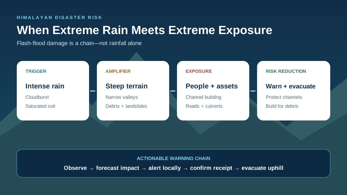
This is why rainfall amount alone does not predict damage. Rainfall intensity, antecedent soil moisture, catchment area, slope, drainage condition and exposure jointly determine impact.
Forecasting and warning system
The India Meteorological Department supplies weather forecasts, nowcasts and hydrometeorological information. The Central Water Commission provides flood forecasting and water-level monitoring, while state and district authorities issue local instructions and organise response. The NDMA’s SACHET platform distributes authorised, geo-targeted alerts through multiple channels.
For a mountain flash flood, the useful chain is:
observation → rainfall/soil/runoff model → impact forecast → local-language alert → last-mile confirmation → evacuation
A forecast has limited value if a hamlet has no siren, the phone network fails, people do not know the safe route, or warnings use vague language. Thresholds should be linked to specific actions: suspend traffic, close a campsite, move machinery, evacuate a channel or open a relief shelter.
Major governance gaps
- Coarse observations: cloudbursts may occur between rain gauges; more automatic stations and weather radars are needed.
- Fragmented data: rainfall, river, slope, dam and road data may sit with separate agencies.
- Unsafe land use: flood channels and debris fans are occupied despite known risk.
- Drainage failures: undersized culverts and blocked drains concentrate water.
- Weak enforcement: environmental conditions, muck-disposal rules and building codes are not consistently enforced.
- Tourist exposure: visitors may not understand local hazards, alerts or evacuation routes.
- Response dependence: helicopters and central teams are important, but weather can delay access; communities must manage the first hours.
Risk reduction for Himalayan districts
- Map micro-catchments: identify active channels, debris-flow paths, landslide zones and safe assembly areas at settlement scale.
- Enforce no-build zones: protect river corridors, drainage lines and alluvial fans from permanent occupation.
- Audit infrastructure: design bridges and culverts for water plus sediment and woody debris, not clear-water discharge alone.
- Monitor slopes and rainfall: integrate radar, gauges, soil moisture, satellite observations and community reports.
- Regulate hill cutting and muck: stabilise slopes, restore drainage and penalise disposal into valleys.
- Plan hydropower cumulatively: assess basin-wide construction, reservoir operation, sediment and emergency communication.
- Practise evacuation: mark routes above flood level, conduct drills and include schools, workers and tourists.
- Build back safer: post-disaster reconstruction should relocate repeatedly damaged assets rather than reproduce the same exposure.
What should citizens do?
- Follow IMD, district administration, HPSDMA and SACHET alerts rather than unverified forwards.
- Move immediately to higher ground if water rises rapidly, a stream turns muddy, boulders begin moving or a roaring sound is heard.
- Do not cross flowing water by foot or vehicle; depth and road condition are difficult to judge.
- Stay away from bridges, culverts, steep cut slopes and riverbanks during intense rain.
- Keep medicines, documents, a torch, radio/power bank and water in a small emergency kit.
UPSC and State PSC relevance
Himachal Pradesh flash floods connect GS Paper I physical geography with GS Paper III disaster management, infrastructure and climate adaptation. A strong answer explains the hazard chain, distinguishes related terms and moves from relief-centric response to risk-sensitive development.
Mains practice question: In the Himalayan region, flash-flood disasters are produced as much by patterns of exposure and construction as by intense rainfall. Examine and suggest a catchment-based risk-reduction strategy.
Conclusion
Flash floods cannot be prevented, but their human impact can be sharply reduced. Himachal Pradesh needs denser observations, actionable warnings, protected drainage corridors, safer roads and genuine enforcement of land-use rules. The objective is not merely faster rescue after a cloudburst; it is to ensure that settlements and infrastructure are not repeatedly rebuilt in the path of the next surge.
Frequently asked questions
What is a flash flood?
It is a rapid surge of water in a stream, channel or low-lying area after intense rain or a sudden release of stored water, usually with very little warning time.
Is a cloudburst the same as a flash flood?
No. A cloudburst is a localised extreme-rainfall event. A flash flood is the rapid flow response that may follow it.
Why are Himalayan flash floods destructive?
Steep slopes, narrow valleys, fragile geology and debris accelerate and concentrate runoff, while roads and settlements are often located close to channels.
Which agencies issue warnings?
IMD provides weather warnings, CWC monitors and forecasts floods, and state and district authorities communicate local action. NDMA’s SACHET platform disseminates authorised geo-targeted alerts.
What is the most important long-term measure?
Risk-sensitive land use: keep permanent construction away from active channels, debris-flow paths and repeatedly inundated land, supported by micro-level hazard maps.
Official references
- India Meteorological Department: forecasts and weather warnings
- Central Water Commission: flood forecasting
- NDMA SACHET: national disaster alert portal
- Himachal Pradesh State Disaster Management Authority





Sources and further reading
- India Meteorological Department: forecasts and weather warningsmausam.imd.gov.in
- Central Water Commission: flood forecastingcwc.gov.in
- NDMA SACHET: national disaster alert portalsachet.ndma.gov.in
- Himachal Pradesh State Disaster Management Authorityhpsdma.nic.in