January 25, 2026 12:35 pm
The General Introduction of Jharkhand begins with its official formation on 15th November 2000, making it the 28th state of India. This milestone followed the creation of Chhattisgarh (26th state on 1st November 2000) and Uttarakhand (27th state on 9th November 2000). The date holds special significance as it coincides with the birth anniversary of Bhagwan Birsa Munda, a legendary tribal leader and freedom fighter born in Ulihatu village, located in the Khunti district of Jharkhand.
To honor Bhagwan Birsa Munda’s contributions and preserve tribal heritage, the Government of India designated 15th November as ‘Tribal Pride Day’ (Janjatiya Gaurav Diwas). This day has been celebrated annually since 2021, marking an essential aspect of Jharkhand’s cultural pride and historical identity.
With its rich history, cultural significance, and recognition of tribal heritage, the General Introduction of Jharkhand reflects its vital role in India’s socio-political and cultural landscape.
Formation and Geographical Division
- Separation from Bihar: Jharkhand was formed by the division of 46% of the land area of Bihar, establishing it as an independent state.
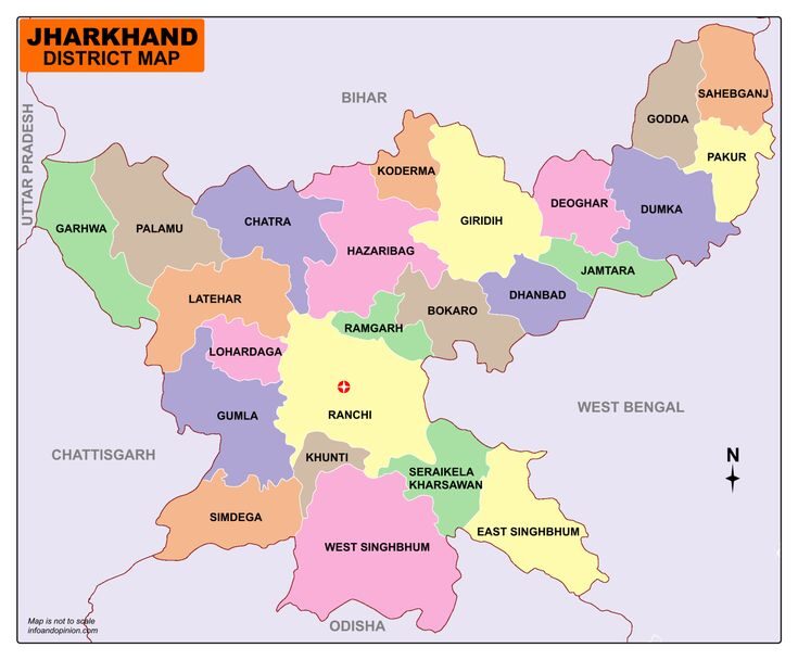
- District Expansion: Initially consisting of 18 districts, Jharkhand has grown to include 24 districts today. The following six districts were created post-formation:
- Latehar (from Palamu)
- Jamtara (from Dumka)
- Simdega (from Gumla)
- Saraikela-Kharsawan (from West Singhbhum)
- Khunti (from Ranchi)
- Ramgarh (from Hazaribagh)
Bordering States and Neighboring Districts
Jharkhand is strategically bordered by several states, with certain districts adjoining two or more neighboring states:
| District | Neighboring States |
|---|---|
| Garhwa | Bihar, Uttar Pradesh, Chhattisgarh |
| Simdega | Chhattisgarh, Odisha |
| Saraikela-Kharsawan | Odisha, West Bengal |
| East Singhbhum | Odisha, West Bengal |
| Dumka | West Bengal, Bihar |
| Sahebganj | West Bengal, Bihar |
Cultural and Historical Significance
Jharkhand’s identity is deeply rooted in its tribal culture, as evident in the legacy of Birsa Munda and the state’s rich history of tribal pride and heritage. Its formation marked the recognition of this unique cultural landscape within India, and the annual observance of Tribal Pride Day reflects a continued commitment to honoring the traditions and contributions of Jharkhand’s indigenous communities.
Jharkhand: Districts Bordering Neighboring States
Jharkhand, a state located in eastern India, shares borders with five states: Bihar, West Bengal, Odisha, Chhattisgarh, and Uttar Pradesh. Certain districts in Jharkhand have unique geographical placements, adjoining multiple neighboring states. Here is a breakdown of Jharkhand’s districts that share borders with each neighboring state, useful for JSSC CGL and other general knowledge examinations:
1. Districts Adjoining Bihar
- Total Districts: 10
- Bordering Districts: Garhwa, Palamu, Chatra, Hazaribagh, Koderma, Giridih, Deoghar, Dumka, Godda, Sahebganj
2. Districts Adjoining West Bengal
- Total Districts: 10
- Bordering Districts: Sahebganj, Pakur, Dumka, Jamtara, Dhanbad, Bokaro, Ramgarh, Ranchi, Saraikela-Kharsawan, East Singhbhum
3. Districts Adjoining Odisha
- Total Districts: 4
- Bordering Districts: East Singhbhum, Saraikela-Kharsawan, West Singhbhum, Simdega
4. Districts Adjoining Chhattisgarh
- Total Districts: 4
- Bordering Districts: Simdega, Gumla, Latehar, Garhwa
5. Districts Adjoining Uttar Pradesh
- Total Districts: 1
- Bordering District: Garhwa
Geographical Introduction of Jharkhand
- Location and Position on the World Map
- Situated in the North-Eastern part of India, Jharkhand is a land-locked state with no coastal boundaries.
- Shape and Area
- Jharkhand has a quadrilateral shape and covers a total area of 79,714 sq. km (79,716 sq. km as per ISFR, 2021).
- Rural Area: 77,922 sq. km, comprising 97.75% of the total area.
- Urban Area: 1,792 sq. km, making up 2.25% of the total area.
- Percentage of India’s Total Area: Jharkhand occupies 2.42% of the country’s land area.
- Position by Area Among Indian States: 15th largest.
- Districts with Maximum and Minimum Area
- Largest District: West Singhbhum, covering 7,224 sq. km.
- Smallest District: Ramgarh, with an area of 1,341 sq. km.
- Latitude and Longitude
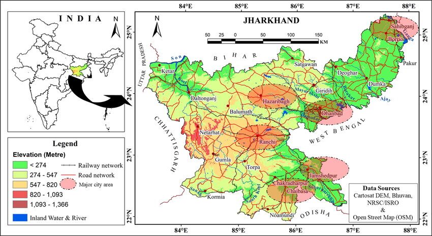
- Latitudinal Range: 21°58’10” N to 25°19’15” N.
- Longitudinal Range: 83°19’50” E to 87°57′ E.
- Dimensions of Jharkhand
- Length (North to South): 380 km.
- Width (East to West): 463 km.
- Geographical Boundaries with Neighboring States
- Jharkhand shares borders with five states:
- North: Bihar (10 districts of Jharkhand adjoin Bihar).
- South: Odisha (4 districts of Jharkhand adjoin Odisha).
- East: West Bengal (10 districts of Jharkhand adjoin West Bengal).
- West: Chhattisgarh (4 districts of Jharkhand adjoin Chhattisgarh).
- North-West: Uttar Pradesh (1 district of Jharkhand adjoins Uttar Pradesh).
- Jharkhand shares borders with five states:
- Highest Peak
- Parasnath in Giridih is the highest peak, standing at 1,365 meters (4,478 feet).
- Climate
- Jharkhand has a tropical monsoon climate, experiencing distinct seasonal variations with significant monsoon rainfall.
- Forest Cover
- ISFR-2019: Jharkhand’s forest cover was 23,611 sq. km (29.62% of total area).
- ISFR-2021: Forest cover increased to 23,721 sq. km (29.76% of total area).
Economic Introduction of Jharkhand
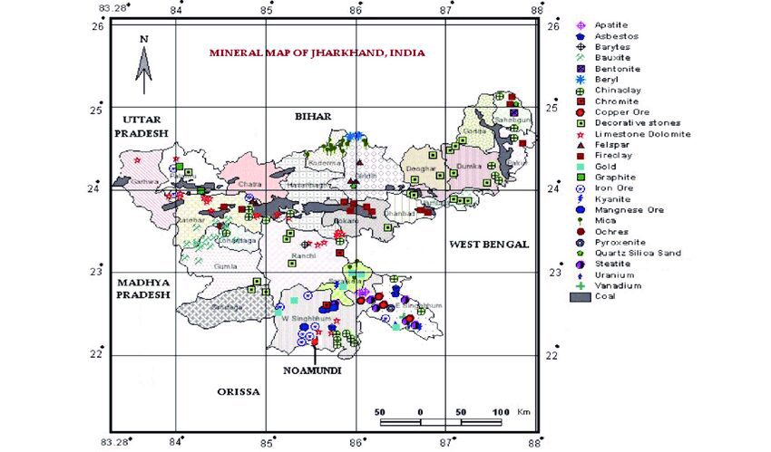
Jharkhand is one of India’s richest states in terms of mineral resources, often referred to as the ‘Mineral Heart of India’. It accounts for over 40% of the country’s total mineral wealth, including coal, iron ore, copper, mica, bauxite, and uranium. The state is a hub for heavy industries and hosts major public sector undertakings like Steel Authority of India Limited (SAIL), Coal India Limited, and Hindustan Copper Limited, along with private industrial giants such as Tata Steel in Jamshedpur. Agriculture and forestry also play a significant role in the state’s economy, supporting the majority of its rural population. Additionally, Jharkhand’s emerging sectors like tourism, IT, and renewable energy are contributing to its growing economic diversity.
- Mineral Wealth:
- Contribution: Jharkhand holds approximately 40% of India’s total mineral resources, making it one of the country’s richest states in mineral wealth.
- Nicknames: Known as the “Ruhr of India” and “Ratnagarbha” due to its vast mineral reserves.
- Mineral Availability:
- The state has 58 types of minerals available, including coal, iron ore, copper, bauxite, uranium, and limestone.
- Economic Foundation:
- The state’s economy primarily relies on minerals and industries.
- Energy Resources:
- Jharkhand’s main energy sources are coal and water.
- Power Production Capacity: Jharkhand has an energy production capacity of 2,626 MW.
- Central Government Contribution: 25.63%
- State Government Contribution: 31.23%
- Private Sector Contribution: 43.14%
- Forest-Based Industries:
- Due to its vast forest cover, Jharkhand has a well-developed forest-based industry sector, supporting industries like paper, furniture, and lac production.
- Major Industrial Cities:
- Jamshedpur (known for Tata Steel), Ranchi, Bokaro (steel production), and Dhanbad (coal mining) are the primary industrial hubs.
- Transportation Infrastructure:
- National Highways: 3,367 km.
- State Highways: 1,232 km.
Political Introduction of Jharkhand
- Administrative Divisions:
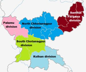
- Number of Divisions: 5 (Palamu, North Chhotanagpur, South Chhotanagpur, Santhal Pargana, Kolhan).
- Largest Division by Districts: North Chhotanagpur with 7 districts.
- Districts and Blocks:
- Total Districts: 24 (18 districts at the time of formation in 2000).
- Districts with Maximum Blocks: Palamu (21 blocks) and Garhwa (20 blocks).
- Sub-Divisions and Blocks:
- Sub-Divisions: 45 (originally 33).
- Total Blocks: 263.
- Rural and Urban Settlements:
- Villages: 32,620.
- Gram Panchayats: 4,403.
- Wards: 1,400.
- Local Urban Bodies:
- Nagar Nigam (Municipal Corporations): 9 (Ranchi, Hazaribagh, Dhanbad, Giridih, Chas, Adityapur, Mango, Deoghar, Medininagar).
- Nagar Parishad (Municipal Councils): 20.
- Nagar Panchayat (Town Councils): 20.
- Notified Area Committee: 1 (Jamshedpur).
- Cantonment Areas: 3 (Ramgarh).
- Metropolitan Cities: 3 (Ranchi, Jamshedpur, Dhanbad).
- Cities with Population Over 1 Lakh: 10 cities.
- State Leadership:
- Governor: Ramesh Bais (10th Governor); first was Prabhat Kumar.
- Chief Minister: Hemant Soren (11th Chief Minister).
- First Chief Minister: Babulal Marandi.
- Most Terms: Arjun Munda and Shibu Soren (each served three times).
- Longest Tenure: Arjun Munda.
- Longest Tenure in a Single Term: Raghubar Das.
- Legislative and Judicial Heads:
- Speaker of Vidhan Sabha: Ravindranath Mahto.
- Chief Justice of Jharkhand High Court: Justice (Dr.) Ravi Ranjan.
- High Court Location: Ranchi (21st High Court in India).
Political Structure of Jharkhand
- Vidhan Sabha (Legislative Assembly) Seats:
- Total Seats: 82
- Elected Seats: 81 (28 reserved for ST, 9 for SC)
- Nominated Seat: 1
- Lok Sabha Seats:
- Total Seats: 14 (5 reserved for ST, 1 for SC)
- Rajya Sabha Seats:
- Total Seats: 6
- Constituency Sizes:
- Largest MP Constituency: West Singhbhum
- Smallest MP Constituency: Chatra
- President’s Rule:
- Jharkhand has been under President’s Rule three times: in 2009, 2010, and 2013.
State Symbols
| Title | Symbol | Scientific Name |
|---|---|---|
| State Tree | Sal | Shorea robusta |
| State Flower | Palash | Butea monosperma |
| State Animal | Elephant | Elephas maximus |
| State Bird | Koel | Eudynamys scolopaceus |
New State Emblem of Jharkhand
- Unveiled: 14th August 2020
- Effective: 15th August 2020
- Design & Symbolism:
- Circular Shape: Represents the state’s progress.
- Green Color: Symbolizes Jharkhand’s lush greenery.
- 24 Elephants: Denote the richness in resources and wealth across 24 districts.
- 24 Palash Flowers: Indicate the natural beauty of the state.
- 48 Tribal Dancers (Saura Painting): Reflect the heritage of Jharkhand’s tribal culture.
- 60 Circles: Represent unity and harmony.
- Central Ashoka Pillar: Embodies cooperative federalism and Jharkhand’s role within India.
Educational Institutions
- Universities in Jharkhand: 32
- Central University: 1
- Deemed University: 1
- Institutes of National Importance: 5
- State Public Universities: 11
- State Private Universities: 14
Linguistic Diversity
- Official Language: Hindi
- Second State Languages: 16, including Urdu, Bangla, Odia, Santhali, Mundari, Ho, Kharia, Kudukh, Khortha, Nagpuri, Kurmali, Panchpargania, Bhojpuri, Maghi, Maithili, and Angika.
Tribal Diversity
- Scheduled Tribes: 32 recognized tribes
- Primitive Tribes: 8
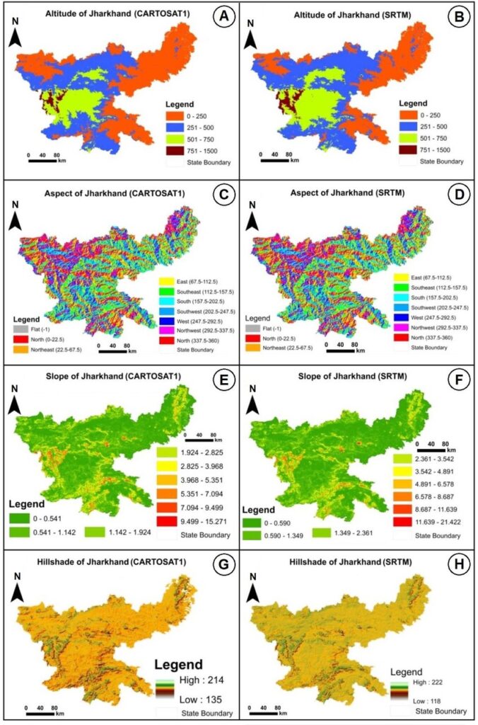
For comprehensive information on Jharkhand, including its government departments, tourism, and public services, the following official websites are essential resources:
- Jharkhand State Portal: The official portal provides access to information and services offered by various state departments. Jharkhand Government
- Department Directory: A detailed directory of all government departments in Jharkhand, including contact information and official websites. Jharkhand Government
- Jharkhand Tourism: Official website offering insights into tourist attractions, accommodations, and cultural heritage of Jharkhand. Jharkhand Tourism
posts related to JPSC on LearnPro’s website:
- JPSC Notes: Access expertly curated notes covering essential topics for both JPSC Prelims and Mains exams.
- 14th JPSC PT Exam Comprehensive Test Series: Enhance your preparation with a structured test series designed to cover all aspects of the JPSC Preliminary Test syllabus, emphasizing Jharkhand-specific topics and current affairs.
- JPSC Notification 2024: Stay informed about the latest updates, including exam dates, eligibility criteria, and vacancy details for the JPSC 2024 examination.
- General Introduction to Jharkhand for JPSC Exam: Gain a comprehensive understanding of Jharkhand’s history, geography, economy, and culture, crucial for the JPSC exam.




[…] General Introduction to Jharkhand for JPSC Exam: Gain a comprehensive understanding of Jharkhand’s history, geography, economy, and culture, crucial for the JPSC exam. […]
[…] General Introduction to Jharkhand for JPSC Exam: Gain a comprehensive understanding of Jharkhand’s history, geography, economy, and culture, crucial for the JPSC exam. […]
[…] General Introduction to Jharkhand for JPSC Exam: Gain a comprehensive understanding of Jharkhand’s history, geography, economy, and culture, crucial for the JPSC exam. […]
[…] General Introduction to Jharkhand for JPSC Exam: Gain a comprehensive understanding of Jharkhand’s history, geography, economy, and culture, crucial for the JPSC exam. […]
[…] General Introduction to Jharkhand for JPSC Exam: Gain a comprehensive understanding of Jharkhand’s history, geography, economy, and culture, crucial for the JPSC exam. […]
[…] General Introduction to Jharkhand for JPSC Exam: Gain a comprehensive understanding of Jharkhand’s history, geography, economy, and culture, crucial for the JPSC exam. […]
[…] General Introduction to Jharkhand for JPSC Exam: Gain a comprehensive understanding of Jharkhand’s history, geography, economy, and culture, crucial for the JPSC exam. […]
[…] General Introduction to Jharkhand for JPSC Exam: Gain a comprehensive understanding of Jharkhand’s history, geography, economy, and culture, crucial for the JPSC exam. […]
[…] General Introduction to Jharkhand for JPSC Exam: Gain a comprehensive understanding of Jharkhand’s history, geography, economy, and culture, crucial for the JPSC exam. […]